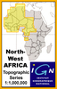
More From Contributor

£12.99
Topographic survey of France at 1:25, 000 in IGN`s excellent TOP25 / Série Bleue series. All the maps are GPS compatible, with a 1km UTM grid plus latitude & longitude lines at 5’ intervals. Contours are at 5m intervals except for mountainous areas where the maps have contours at 10m intervals, vividly enhanced by hill shading & graphics for rocky terrain. Colouring with graphics indicates different types of vegetation or land use (deciduous or coniferous forests, moors, orchards, vineyards, etc). PLEASE NOTE: coverage of France at this scale is currently being revised – the format & the presentation of each title are indicated by the letters at the end of its Sheet Reference number (e.g. 0416ET, 3531ETR, 1923SB, etc.)MAPS WITH FULL TOURIST OVERPRINT & AN ENGLISH MAP LEGEND: all TOP25 maps & the SB editions of Série Bleue have an overprint highlighting waymarked walking trails including long-distance GR routes &, where appropriate, ski routes. Symbols indicate campsites, gîtes d’etape, refuges, equestrian centres & other recreational facilities or sites, tourist information centres, cultural heritage, etc. Towns & locations of particular interest are highlighted.- ET or OT = single-sided TOP25 map covering approx. 29x 21 km / 18x 13 miles.- ETR or OTR = waterproof & tear resistant TOP25 map covering the same area as the corresponding ET or OT number, but double-sided, printed on a smaller size sheet with a good overlap between the sides.- SB = Série Bleue map with full tourist overprint; these maps, first introduced in summer 2014, each cover approx. 29x 24km / 18x 15 miles.SÉRIE BLEUE maps with numbers ending in E (Est) or O (Ouest): most editions now indicate the GR routes, but do not show any other tourist information. Map legend is in French only. Each map covers approx. 14x 20km / 9x 12 miles. ...
Archived Product
£11.99
One of the titles in a series of topographic maps covering much of north-west Africa, produced as part of the IMW* project in 1960’s. Each map covers an area spanning 6° in longitude & 4° in latitude. There is some variation in colouring & the depiction of terrain, but hill-shading, spot heights & contours are used to show the general relief. Additional graphics show features such as dunes, rock outcrops, cliffs, sand areas, escarpments, marshes, seasonal lakes & watercourses, & areas liable to flooding. Bathymetric contours are also included. Communications detail

Includes::
roads, major trails & railways, although there is some inconsistency in colouring & the extent of classification, e.g. not all maps distinguish seasonal roads. On most maps intermediate road distances are indicated on main routes. Symbols show airports, mosques, mines, oil & gas fields, lighthouses, ruins & significant isolated buildings. Administrative boundaries are marked & latitude & longitude lines are drawn at 1° intervals, with further margin ticks at 1’ intervals. The map legend is in French only on some sheets, & in English & French on others.* The International Map of the World was a project conceived in the early 20th century to compile a world map series at 1:1, 000, 000 through the efforts of participating nations. The value of the program has declined since 1970 & the IMW is no longer regarded as an active international series.

...
Archived Product
£19.99
In researching this book, John travelled into the heart of the High Atlas Mountains to learn the secrets of traditional lamb barbecue, then journeyed north, through the city of Fes, where the rich dishes of the Imperial Courts are still prepared in many homes. From here he continued on to the Rif Mountains, where rustic recipes are made with the freshest seasonal produce. From Moroccan-style paella, cooked in the blue town of Chefchaouen, to stuffed Berber breads baked in the hot desert sands, John has discovered the real food of the country, learning from the locals to reveal little-known dishes, which he then gives his modern twist. The chapters include Streetfood, Salads & Vegetables, Meat & Poultry, Seafood, Tagines & Desserts, plus a section of spice mixes & marinades from chermoula to harissa. With mouthwatering recipes, breathtaking location photography & John`s infectious enthusiasm, this is an essential addition to every cook`s collection. ...
Archived Product
£9.99
These noir stories take readers on a hard-boiled tour behind the Orange curtain where a reclusive rock star has lived way too long in his own head, a crooked judge uses the court for illicit means, a cab driver prowls the streets with more than the ticking meter on his mind, where cultures clash, housewives want more than the perfect grout cleaner & nobody is who they seem to be.

Includes::
contributions from Edgar Award winner Susan Straight, Hammett Award nominee Robert Ward, LA Times bestseller Barbara De Marco-Barrett & Nero Wolfe Award winner Dick Lochte.

...
Archived Product
£6.50
Orange County South: Mission Viejo
- San Clemente area of California on an indexed street plan from Rand Mc Nally in their extensive
...
Archived Product
£12.95
A 298km long cycle route associated with the House of Orange-Nassau. Detailed maps show the route & its variants & extensive information is conveyed by symbols, indicating road surface, campsites & other accommodation, repair workshops, recreational facilities, places of interest, etc. A list of various types of accommodation facilities is included.IMPORTANT
- PLEASE NOTE: ALL THE TEXT IN THIS TITLE IS GERMAN ONLY. MAP LEGEND

Includes::
ENGLISH, please see our sample image, & the information provided on the maps is sufficient to use this title without any knowledge of German, particularly in the absence of a similar product in English from other publishers. There is currently no English edition this title available in this series. About the series: All the titles have been meticulously researched & are highly regarded in their native Germany. Most titles, as indicated in their individual descriptions, also include a separate section listing selected accommodation, from hotels to campsites, youth hostels & rooms in private houses, all with addresses, telephone numbers & price range. Information on towns along each route

Includes::
a list of places of interest, with opening hours, etc. Several of the guides also have street plans.


...
Archived Product
£7.99
Not cool enough, not clever enough, not street enough for anyone to notice me. I was the kid people looked straight through. NOT ANY MORE. NOT SINCE MR ORANGE. Sixteen-year-old Marlon has made his mum a promise
- he`ll never follow his big brother, Andre, down the wrong path. So far, it`s been easy, but when a date ends in tragedy, Marlon finds himself hunted. They`re after the mysterious Mr Orange, & they`re going to use Marlon to get to him. Marlon`s out of choices
- can he become the person he never wanted to be, to protect everyone he loves?

...
Archived Product
£8.99
This is the story of Jeanette, adopted & brought up by her mother as one of God`s elect. Zealous & passionate, she seems destined for life as a missionary, but then she falls for one of her converts. At sixteen, Jeanette decides to leave the church, her home & her family, for the young woman she loves. Innovative, punchy & tender, Oranges Are Not the Only Fruit is a few days ride into the bizarre outposts of religious excess & human obsession. With a new introduction by the author. ...
Archived Product
£17.99
The 1:50 000 topographic map gives a more general picture of the ground features than a basic map. It shows settlements, houses, roads, cultivated areas, waterways, cutting areas, mires, rock exposures, & relief. One map sheet covers an area of 30 x 40 km & one centimetre corresponds to 500 metres on the ground. The 1:50, 000 topographic map is also an ideal complement to nautical charts as it provides useful information about the land areas adjacent to waterways. For example, all Finnish sea areas are covered by 1:50 000 topographic map sheets. ...
Archived Product
£6.50
Topographic coverage of mainland Spain at 1:25, 000 published by the Centro Nacional de Información Geograficá, the country’s civilian survey organization. The maps have contours at 10m intervals & colouring and/or graphics to show different types of vegetation or land use. Boundaries of national parks & other protected areas are marked. In addition to all the usual information shown on topographic maps at this scale, detailed presentation of the road & rail networks, rural tracks & paths, etc, the maps also show campsites. The maps have a 1-km UTM grid, with margin ticks for latitude & longitude at 1` intervals. Map legend is in Spanish only.PLEASE NOTE: our grid for the whole of Spain is in preparation
- in the meantime, for areas other than those shown on the attached grid please use CNIG’s topographic survey at 1:50, 000 by searching for ‘SI00000832’. Each 25K map covers one quarter of the corresponding 50K map, with the numbering system: I = NW quarter, II = NE quarter, III = SW quarter & IV = SE quarter. CNIG maps in the Provincial Road Maps series at 1:200, 000 are overprinted with the grid for the 1:50, 000 survey & can be used to see the area covered by each 50K or 25K title in more detail. To see the list of titles in this series please click on the series grid
- for map numbers not yet listed on our website please contact us by email.

...
Archived Product

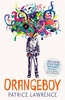
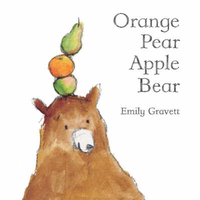
Orange Pear Apple Bear

The utter simplicity of this beautiful picture book is breathtaking. By rearranging just four words, Emily Gravett creates a series of playful images which are a sheer joy -- and intensely satisfying. The loose energy of the pencil and watercolour pictures will be irresistible to adults and children alike.
RIP - This product is no longer available on our network. It was last seen on 25.09.2019

This page now acts as a permanent archive for this product. Add more information using the comments box below to ensure it can still be found by future generations.

Use our search facility to see if it is available from an alternative contributor.
  • Availability: Out Of Stock
  • Supplier: Stanfords
  • SKU: 9781405090223
Availability: In Stock
£4.99

Product Description

The utter simplicity of this beautiful picture book is breathtaking. By rearranging just four words, Emily Gravett creates a series of playful images which are a sheer joy -- & intensely satisfying. The loose energy of the pencil & watercolour pictures will be irresistible to adults & children alike.

Reviews/Comments

Add New

Intelligent Comparison

Oooops!
We couldn't find anything!
Perhaps this product's unique.... Or perhaps we are still looking for comparisons!
Click to bump this page and we'll hurry up.

Price History

Vouchers

No voucher codes found.
Do you know a voucher code for this product or supplier? Add it to Insights for others to use.

Facebook

Jargon Buster

Loose - The opposite to tight
Satisfying - A feeling of pleasure and fulfilment.
Children - A young life form within the early stages of physical development,

Supplier Information

Stanfords
Stanfords was established in 1853 and opened their iconic Covent Garden flagship store in 1901. They have become the top retailer of maps, travel books and accessories in the UK and arguably offer the largest selection of maps and travel books worldwide. Famous names such as Captain Robert Falcon Scott, Ranulph Fiennes and Michael Palin have purchased from Stanfords. They now have a shop in Bristol and both stores together with other venues operate a calendar of events including talks, book signings and exhibitions. As a specialist map retailer, the map selection is comprehensive and includes road maps, street maps and walking maps from worldwide destinations, as well as a selection of world atlases and wall maps. Books include travel guides and travel literature. Stanfords also stock globes, from miniatures made of blue marble to magnificent floor-standing globes. The website features a selection of interesting articles on travel topics.
Page Updated: 2023-11-12 20:15:36

Community Generated Product Tags

Oh No! The productWIKI community hasn't generated any tags for this product yet!
Menu