More From Contributor
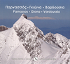
£10.99
Parma at 1: 12, 000 on indexed street plans from Litografia Artistica Cartografica in their Globalmap imprint, with a detailed enlargement of the city’s historic centre at 1:5, 000. 48 monuments including historic buildings & churches, cultural or educational institutions, & important municipal buildings or facilities are numbered & listed next to the plan. An inset extends the coverage to S. Pancrazio Parmense & Quartiere la Palazzina. Litografia Artistica Cartografica (LAC) are Italy’s leading publishers of street plans with an extensive range of titles. Where appropriate, the plans include an enlargement showing the historic centre in greater detail. On each plan monuments including historic buildings & churches, archaeological sites, cultural or educational institutions, & important municipal buildings or facilities are numbered & listed next to the plan. Unless indicated to the contrary in the individual description, one way streets are not marked. Street index is on the reverse. ...
Archived Product
£7.95
Parma Province in a series of handy size road maps from Litografia Artistica Cartografica (LAC) with more minor local roads & tracks than can be found on most regional maps. The series is gradually being changed to a new style of digitally derived cartography, so presentation of adjoining titles may vary. All the maps have hill shading to represent the general relief with spot heights for selected peaks, & show a few more local roads & rough tracks than the other road map series. Intermediate road distances are indicated. Regional, provincial & communal borders are marked, & railways, funiculars, airports, sea ferry links & campsites are shown. The legend is in Italian only. The new, digitally produced editions are indexed & have enhanced, more finely drawn cartography: the hill-shading is less bold, motorway service areas are marked, natural parks are highlighted & an expanded range of symbols indicates various landmarks & sites, e.g. antiquities, churches, etc. Two styles of the new cartography are produced, differing only in the colour of the predominant background shading: grey or yellow/green. Some of the new editions include geographical coordinates for the map corners. The index of localities is on the reverse. This title is now published with digital cartography. ...
Archived Product
£8.95
Parma Province in a series of handy size road maps from Litografia Artistica Cartografica (LAC) with more minor local roads & tracks than can be found on most regional maps. The series is gradually being changed to a new style of digitally derived cartography, so presentation of adjoining titles may vary. All the maps have hill shading to represent the general relief with spot heights for selected peaks, & show a few more local roads & rough tracks than the other road map series. Intermediate road distances are indicated. Regional, provincial & communal borders are marked, & railways, funiculars, airports, sea ferry links & campsites are shown. The legend is in Italian only. The new, digitally produced editions are indexed & have enhanced, more finely drawn cartography: the hill-shading is less bold, motorway service areas are marked, natural parks are highlighted & an expanded range of symbols indicates various landmarks & sites, e.g. antiquities, churches, etc. Two styles of the new cartography are produced, differing only in the colour of the predominant background shading: grey or yellow/green. Some of the new editions include geographical coordinates for the map corners. The index of localities is on the reverse. This title is now published with digital cartography. ...
Archived Product
£12.99
Parma Province at 1:150, 000 in a series of handy size provincial road maps from Litografia Artistica Cartografica (LAC) with more minor local roads & country tracks than can be found on most regional maps from other publishers. This title is now available in a digitally produced edition.LAC’s provincial series is gradually being changed to a new style of digitally derived cartography, so presentation of adjoining titles may vary. All the maps have hill shading to represent the general relief with spot heights for selected peaks, & show a few more local roads & rough tracks than the other road map series. Intermediate road distances are indicated. Regional, provincial & communal borders are marked, & railways, funiculars, airports, sea ferry links & campsites are shown. The legend is in Italian only. The new, digitally produced editions are indexed & have enhanced, more finely drawn cartography: the hill-shading is less bold, motorway service areas are marked, natural parks are highlighted & an expanded range of symbols indicates various landmarks & sites, e.g. antiquities, churches, etc. Two styles of the new cartography are produced, differing only in the colour of the predominant background shading: grey or yellow/green. Some of the new editions include geographical coordinates for the map corners. The index of localities is on the reverse. To see all the titles in this series please click on the series link. ...
Archived Product
£9.50
Parnassos at 1:50, 000 in a series of contoured maps from Road Editions covering popular hiking areas of Greece. All the maps have altitude coloring & spot heights
- contour interval varies, as indicated in the descriptions of individual titles. Local footpaths are marked &, for road users the maps show picturesque routes, intermediate driving distances on minor roads, & locations of petrol stations & tyre repairs workshops. Boundaries of national parks & administrative regions are marked, & symbols show campsites, hotels & mountain refuges, & various landmarks & places of interest, e.g. archaeological sites, churches, etc. All place names are in both Greek & Latin alphabet. All the titles have latitude & longitude margin ticks, many also show GPS waypoints. Some maps come with a booklet or notes on the reverse side giving further information about the area and/or descriptions of hiking routes. Map legends include English. In this title: Mount Parnassos & the surrounding area, covering Approx. 35 x 34 km / 22 x 21 miles. The booklet, in Greek & English,

Includes::
an index, general information about the area & a detailed description of an ancient path from the famous Temple of Apollo in Delphi to the Coryncian cave. Please note: Items from this publisher can have long delivery times. If your selected item is displayed as not in stock & you need the item within 4 weeks, to avoid disappointment we suggest you order a similar item from an alternative publisher.


...
Archived Product
£8.50
Parnassos
- Kirfis area in a waterproof & tear-resistant hiking map at 1:35, 000, with a UTM grid for GPS users. Relief shading,
...
Archived Product
£17.95
Part of a series of books from Anavasi publishing showing certain Greek landscapes from an angle rarely seen by the human eye
-
...
Archived Product
£9.50
Parnonas at 1:50, 000 in a series of contoured maps from Road Editions covering popular hiking areas of Greece. All the maps have altitude coloring & spot heights
- contour interval varies, as indicated in the descriptions of individual titles. Local footpaths are marked &, for road users the maps show picturesque routes, intermediate driving distances on minor roads, & locations of petrol stations & tyre repairs workshops. Boundaries of national parks & administrative regions are marked, & symbols show campsites, hotels & mountain refuges, & various landmarks & places of interest, e.g. archaeological sites, churches, etc. All place names are in both Greek & Latin alphabet. All the titles have latitude & longitude margin ticks, many also show GPS waypoints. Some maps come with a booklet or notes on the reverse side giving further information about the area and/or descriptions of hiking routes. Map legends include English. In this title: the Parnonas mountain range in eastern Peloponnese. Coverage extends from Sparta in the south-west corner of the sheet to the Aegean coast between Ayios Andhreas in the north & Pigadi in the south. The booklet has an index, a street plan of Sparta, & suggested routes to explore the area. Please note: Items from this publisher can have long delivery times. If your selected item is displayed as not in stock & you need the item within 4 weeks, to avoid disappointment we suggest you order a similar item from an alternative publisher.
...
Archived Product
£29.95
One of the maps in the topographic survey of Peru from the country’s national survey organization, Instituto Geográfico Nacional. Contours are at 25m intervals & colouring/symbols indicate different types of terrain & vegetation. Some of the maps may contain small blank spaces representing as yet unmapped areas. Each sheet covers 30’ latitude by 30’ longitude. The maps have a 1km UTM grid & margin ticks for latitude & longitude at intervals of 1’. Publication dates vary; most maps were published in 1960s to 1990s, with some sheets revised more recently. Map legend is in Spanish only, except in the more recent editions which also include English. ...
Archived Product
£14.95
Part of a series of books from Anavasi publishing showing certain Greek Islands from an angle rarely seen by the human eye
- from
...
Archived Product

Parnassos - Kirfis

Parnassos - Kirfis area in a series of waterproof and tear-resistant hiking maps at scales varying from 1:50, 000 to 1:10, 000, with a UTM grid for GPS users. Contour interval varies depending on the scale, on most maps it is 20m. Relief shading, spot heights, springs, seasonal streams and, in most titles, landscape/land-use variations, e.g. forests, orchards, or vineyards provide additional information on the terrain. Place names are given in both Greek and Roman script.Local footpaths, hostels and mountain huts are clearly marked. For road users intermediate driving distances and petrol stations are shown. Symbols highlight places of interest, including archaeological sites, churches and monasteries, etc. The maps have a UTM grid and margin ticks for latitude and longitude.
Map legend includes English.In this title: the eastern and western Parnassos highlands, extending out to surrounding towns of Gravia, Amfisa, Itea, Dhistomo, Dhavia, and Elatia. The boundary of the Parnassos National Park is marked. On the reverse is a smaller, simplified version of the same map without the topographic detail, simply highlighting roads and waymarked hiking routes: sections of route 22 which crosses Mt Kirfi, and the long-distance E4 route.
RIP - This product is no longer available on our network. It was last seen on 25.09.2019

This page now acts as a permanent archive for this product. Add more information using the comments box below to ensure it can still be found by future generations.

Use our search facility to see if it is available from an alternative contributor.
  • External links may include paid for promotion
  • Availability: Out Of Stock
  • Supplier: Stanfords
  • SKU: 9789608195400
Availability: In Stock
£7.95

Product Description

Parnassos
- Kirfis area in a series of waterproof & tear-resistant hiking maps at scales varying from 1:50, 000 to 1:10, 000, with a UTM grid for GPS users. Contour interval varies depending on the scale, on most maps it is 20m. Relief shading, spot heights, springs, seasonal streams &, in most titles, landscape/l&-use variations, e.g. forests, orchards, or vineyards provide additional information on the terrain. Place names are given in both Greek & Roman script. Local footpaths, hostels & mountain huts are clearly marked. For road users intermediate driving distances & petrol stations are shown. Symbols highlight places of interest, including archaeological sites, churches & monasteries, etc. The maps have a UTM grid & margin ticks for latitude & longitude. Map legend

Includes::
English. In this title: the eastern & western Parnassos highlands, extending out to surrounding towns of Gravia, Amfisa, Itea, Dhistomo, Dhavia, & Elatia. The boundary of the Parnassos National Park is marked. On the reverse is a smaller, simplified version of the same map without the topographic detail, simply highlighting roads & waymarked hiking routes: sections of route 22 which crosses Mt Kirfi, & the long-distance E4 route.

Reviews/Comments

Add New

Intelligent Comparison

Oooops!
We couldn't find anything!
Perhaps this product's unique.... Or perhaps we are still looking for comparisons!
Click to bump this page and we'll hurry up.

Price History

Vouchers

No voucher codes found.
Do you know a voucher code for this product or supplier? Add it to Insights for others to use.

Facebook

Jargon Buster

GPS - Global Positioning System - Global position using satellites
Hiking - An outdoor activity envolving walking in nature
Waterproof - Resistant to water, usualy specified by depth in metres
Road - a manmade lane or a path that is used to speed up travel.
Resistant - Something that can repel against something.

Supplier Information

Stanfords
Stanfords was established in 1853 and opened their iconic Covent Garden flagship store in 1901. They have become the top retailer of maps, travel books and accessories in the UK and arguably offer the largest selection of maps and travel books worldwide. Famous names such as Captain Robert Falcon Scott, Ranulph Fiennes and Michael Palin have purchased from Stanfords. They now have a shop in Bristol and both stores together with other venues operate a calendar of events including talks, book signings and exhibitions. As a specialist map retailer, the map selection is comprehensive and includes road maps, street maps and walking maps from worldwide destinations, as well as a selection of world atlases and wall maps. Books include travel guides and travel literature. Stanfords also stock globes, from miniatures made of blue marble to magnificent floor-standing globes. The website features a selection of interesting articles on travel topics.
Page Updated: 2023-11-12 20:15:36

Community Generated Product Tags

Oh No! The productWIKI community hasn't generated any tags for this product yet!
Menu