More From Contributor

£13.99
Patagonia Handbook in the Handbooks series from Footprint; comprehensive & leading guides designed & written for independent travellers who enjoy exploring off the beaten track. Footprint guides have an established reputation, built up since 1921, for catering for more adventurous & individual travellers. An unrestrictive editorial style also gives authors the freedom to capture & explore local cultures, sights & areas that are often not covered in other guides. Widely recognised for their reliability & independent writing style, Footprint guides all have the same layout. Introductory sections introduce the reader to the destination, with chapters on planning on your trip & essentials, including practical information & guidance on subjects such as when & where to go, itineraries, sport & activities, arts, getting there & around, eating & drinks, sleeping & a dedicated section on the anticipated carbon footprint involved in travelling to the destination. Each guide is organised geographically by region or country, with individual sections having a particular focus on an extensive range of sights & places of interest. Further, there are also details of accommodation, nightlife, restaurants & any notable local activities. Information boxes throughout the text give readers an insight into local customs, stories & sights of particular interest.A ‘ Background’ section explores the history, economy, government, education, culture, people, land & environment of the destination in significant depth. There is also a ‘ Footnotes’ chapter with a basic language guide for travellers & information about the author. A useful distance chart tailored to the destination is also included in the inside back cover. * Please note:* the series is gradually being revised, reverting to its previous style of ” Handbooks”, published in a hardback format. ...
Archived Product
£14.99
Patagonia at 1:160, 000 on a durable, waterproof & tear-resistant, contoured & GPS compatible map from terra Quest, providing continuous coverage from Monte Fitz Roy to the Torres del Paine National Park & Puerto Natales. The map divides the region north/south with a generous overlap between the sides. The northern half starts at 49 ...
Archived Product
£34.95
Patagonia Vertical climbing guide from Sidarta covering all the peaks & climbs within the Chaltén Massif in Argentina, including Cerro Fitz Roy & Cerro Torre. Colour photos of individual mountain faces show the course of the climbing route (s) & the accompanying descriptions are supplemented by detailed diagrams. The region is divided into six groups: approaches, Cordón Adela, Torre group, Piergiorgio & Pollone group, Cordón Marconi & the Fit Roy group. Introductory sections provide general information about the area, advice about climbing, etc. Many additional photos provide more general views or more detailed pictures of important sites. ...
Archived Product
£39.50
Many regions of Patagonia & Tierra del Fuego still remain uninhabited today due to the inaccessibility of the immense mountain landscapes, high peaks, perilous deserts & jagged coastal fjords. It is one of the most fascinating regions in the world, beautiful enough to take your breath away with its wild untouched nature comparable to nothing else on Earth. Enormous regions still exists that have not been seen by man. This book follows in the footsteps of the great adventurers on their travels to the southern tip of the great American continent. ...
Archived Product
£12.99
Patagonian & Fuegian Channels: Chilean Fjords Cruise Chart from the Buenos Aires based Zagier & Urruty is designed to show travelers along this intricate coastline routes taken by cruise ships, names of fjords & islands, etc, & printed on light, waterproof & tear resistant synthetic paper. Coverage of the Chilean coastline starts at Boca del Guafo & continues south to Cape Horn & then along the coast of Tierra del Fuego to the Straights of Magellan. The main map at 1:1, 400, 000 is supplemented by five insets showing in greater much greater detail the most interesting areas: two panels with the Beagle Channel from the Pacific to beyond Ushuaia, the Agostini Fjord, the Wulaia Inlet & the Orange Bay. Numerous islands, fjords & peninsulas are named, as well as main towns along the coast. Topography is presented only by graphics showing the glaciers, but beautiful, evocative drawings of the kind used in old atlases show many of the most interesting coastal features. The map is decorated by more drawings of ships involved in early explorations of this region. Also provided is a glossary of geographical terms used on the map & a panel for logging cruise dates. Please note: this map is not a maritime chart for navigation. This title is part of the publishers’ series of maps of Patagonia & its most visited regions. ...
Archived Product
£11.50
Topographic survey of France at 1:25, 000 in IGN`s excellent TOP25 / Série Bleue series. All the maps are GPS compatible, with a 1km UTM grid plus latitude & longitude lines at 5’ intervals. Contours are at 5m intervals except for mountainous areas where the maps have contours at 10m intervals, vividly enhanced by hill shading & graphics for rocky terrain. Colouring with graphics indicates different types of vegetation or land use (deciduous or coniferous forests, moors, orchards, vineyards, etc). PLEASE NOTE: coverage of France at this scale is currently being revised – the format & the presentation of each title are indicated by the letters at the end of its Sheet Reference number (e.g. 0416ET, 3531ETR, 1923SB, etc.)MAPS WITH FULL TOURIST OVERPRINT & AN ENGLISH MAP LEGEND: all TOP25 maps & the SB editions of Série Bleue have an overprint highlighting waymarked walking trails including long-distance GR routes &, where appropriate, ski routes. Symbols indicate campsites, gîtes d’etape, refuges, equestrian centres & other recreational facilities or sites, tourist information centres, cultural heritage, etc. Towns & locations of particular interest are highlighted.- ET or OT = single-sided TOP25 map covering approx. 29x 21 km / 18x 13 miles.- ETR or OTR = waterproof & tear resistant TOP25 map covering the same area as the corresponding ET or OT number, but double-sided, printed on a smaller size sheet with a good overlap between the sides.- SB = Série Bleue map with full tourist overprint; these maps, first introduced in summer 2014, each cover approx. 29x 24km / 18x 15 miles.SÉRIE BLEUE maps with numbers ending in E (Est) or O (Ouest): most editions now indicate the GR routes, but do not show any other tourist information. Map legend is in French only. Each map covers approx. 14x 20km / 9x 12 miles. ...
Archived Product
£2.20
Small map from Harvey highlighting 8 walks in the Pateley Bridge area of the Yorkshire Dales, at 1:25, 000. Cartography shows the eight routes with bold colours overprinted on the mapping & detailed descriptions for each walk including along the map edge. Points of interest & local facilities such as tea shops, accommodation, toilets, bus stops & parking are prominently indicated. Topography is displayed through contour lines at 75m intervals, with other terrain details marked such as cliffs & sink holes. The map also has some information on travelling by bus in the region, as well as historical information for the area. ...
Archived Product
£6.50
Topographic coverage of mainland Spain at 1:25, 000 published by the Centro Nacional de Información Geograficá, the country’s civilian survey organization. The maps have contours at 10m intervals & colouring and/or graphics to show different types of vegetation or land use. Boundaries of national parks & other protected areas are marked. In addition to all the usual information shown on topographic maps at this scale, detailed presentation of the road & rail networks, rural tracks & paths, etc, the maps also show campsites. The maps have a 1-km UTM grid, with margin ticks for latitude & longitude at 1` intervals. Map legend is in Spanish only.PLEASE NOTE: our grid for the whole of Spain is in preparation
- in the meantime, for areas other than those shown on the attached grid please use CNIG’s topographic survey at 1:50, 000 by searching for ‘SI00000832’. Each 25K map covers one quarter of the corresponding 50K map, with the numbering system: I = NW quarter, II = NE quarter, III = SW quarter & IV = SE quarter. CNIG maps in the Provincial Road Maps series at 1:200, 000 are overprinted with the grid for the 1:50, 000 survey & can be used to see the area covered by each 50K or 25K title in more detail. To see the list of titles in this series please click on the series grid
- for map numbers not yet listed on our website please contact us by email.

...
Archived Product
£6.95
Topographic coverage of mainland Spain at 1:50, 000 in the MTN50 (Mapa Topográfico Nacional) series from the Centro Nacional de Información Geografica, the country’s civilian survey organization. The maps have contours at 20m intervals, enhanced by relief shading, plus colouring and/or graphics to show different types of terrain, vegetation or land use. Boundaries of national parks & other protected areas are marked. In addition to all the usual information featured on topographic mapping at this scale, detailed presentation of the road & rail networks, rural tracks & paths, etc, the maps also show campsites & mountain refuges. On more recent editions some GRs, the official long-distance hiking routes, are also marked (although not as clearly as on hiking maps from other publishers). Each map covers 29.5x 18.5 km (with adjustments in the border or coastal areas). The maps have a 1-km UTM grid, plus margin ticks for latitude & longitude at 1` intervals. Map legend is in Spanish only.HOW TO CHOOSE THE RIGHT 50K MAP: all the titles in CNIG’s 200K Provincial Road Maps series at 1:200, 000 are overprinted with the grid for the 1:50, 000 maps & can be used to see the area covered by each 50K title. TO SEE THE LIST OF TITLES IN THIS SERIES PLEASE CLICK ON THE SERIES LINK.PLEASE NOTE
- MAP TITLES: the grids shown on our website serve both the civilian & the military 1:50, 000 topographic series. Although the areas covered by maps in both series are identical (apart from some border or coastal sheets), occasionally map titles differ – only one title is shown on the grid, usually the military one. In Galicia, the Basque country & in the Catalan speaking areas the tendency now is to use local place names rather than the often better known Castilian ones. Where possible, both versions are included in our titles. Map titles listed on our website are based on information received by us at the time of publication, but sometimes maps arrive showing a completely different title! As long as the map number is as ordered, the correct map has been supplied.
...
Archived Product
£6.50
Topographic coverage of mainland Spain at 1:25, 000 published by the Centro Nacional de Información Geograficá, the country’s civilian survey organization. The maps have contours at 10m intervals & colouring and/or graphics to show different types of vegetation or land use. Boundaries of national parks & other protected areas are marked. In addition to all the usual information shown on topographic maps at this scale, detailed presentation of the road & rail networks, rural tracks & paths, etc, the maps also show campsites. The maps have a 1-km UTM grid, with margin ticks for latitude & longitude at 1` intervals. Map legend is in Spanish only.PLEASE NOTE: our grid for the whole of Spain is in preparation
- in the meantime, for areas other than those shown on the attached grid please use CNIG’s topographic survey at 1:50, 000 by searching for ‘SI00000832’. Each 25K map covers one quarter of the corresponding 50K map, with the numbering system: I = NW quarter, II = NE quarter, III = SW quarter & IV = SE quarter. CNIG maps in the Provincial Road Maps series at 1:200, 000 are overprinted with the grid for the 1:50, 000 survey & can be used to see the area covered by each 50K or 25K title in more detail. To see the list of titles in this series please click on the series grid
- for map numbers not yet listed on our website please contact us by email.

...
Archived Product

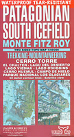
Patagonian South Icefield - Monte Fitz Roy

The South Patagonian Icefield, including Monte Fitz Roy and Cerro Torre, at 1:50, 000 on a light, waterproof and tear-resistant, double-sided trekking map from Zagier & Urruty with an exceptionally vivid presentation of this area’s stunning topography.Coverage extends from Candelario Mancilla on the southern shore of Lago O’Higgins to the famous Viedma Glacier and includes El Chalten. The map has as its base satellite imagery overprinted with contours at 50m intervals plus relief shading and colouring for glaciers and wooded areas, and shows names of numerous peaks, glaciers, valleys, lakes and other geographical features.Several trekking trails and unmarked trekking routes are clearly shown, indicating approximate timings. Numerous GPS waypoints are given for campsites, huts
and other key spots along the trails and local roads. Symbols mark locations of organized or free camping sites, mountain shelters, riding stables, viewpoints, etc. Full topographic, trekking and tourist information is shown on both sides of the border. In addition to the GPS waypoints, latitude and longitude grid is at intervals of 5’. Map legend includes English.This title also includes a large panel with a satellite image of the whole of the South Patagonian Icefield, further out in all four directions than the map itself, overprinted with routes of classic expeditions across the glaciers. Eight smaller line drawings present views with names of peaks within the main groups, e.g. the four sides of the Cerro Torre massif.
RIP - This product is no longer available on our network. It was last seen on 25.09.2019

This page now acts as a permanent archive for this product. Add more information using the comments box below to ensure it can still be found by future generations.

Use our search facility to see if it is available from an alternative contributor.
  • Availability: Out Of Stock
  • Supplier: Stanfords
  • SKU: 9781879568099
Availability: In Stock
£14.99

Product Description

The South Patagonian Icefield, including Monte Fitz Roy & Cerro Torre, at 1:50, 000 on a light, waterproof & tear-resistant, double-sided trekking map from Zagier & Urruty with an exceptionally vivid presentation of this area’s stunning topography. Coverage extends from Candelario Mancilla on the southern shore of Lago O’ Higgins to the famous Viedma Glacier &

Includes::
El Chalten. The map has as its base satellite imagery overprinted with contours at 50m intervals plus relief shading & colouring for glaciers & wooded areas, & shows names of numerous peaks, glaciers, valleys, lakes & other geographical features. Several trekking trails & unmarked trekking routes are clearly shown, indicating approximate timings. Numerous GPS waypoints are given for campsites, huts & other key spots along the trails & local roads. Symbols mark locations of organized or free camping sites, mountain shelters, riding stables, viewpoints, etc. Full topographic, trekking & tourist information is shown on both sides of the border. In addition to the GPS waypoints, latitude & longitude grid is at intervals of 5’. Map legend

Includes::
English. This title also

Includes::
a large panel with a satellite image of the whole of the South Patagonian Icefield, further out in all four directions than the map itself, overprinted with routes of classic expeditions across the glaciers. Eight smaller line drawings present views with names of peaks within the main groups, e.g. the four sides of the Cerro Torre massif.

Reviews/Comments

Add New

Intelligent Comparison

Oooops!
We couldn't find anything!
Perhaps this product's unique.... Or perhaps we are still looking for comparisons!
Click to bump this page and we'll hurry up.

Price History

Vouchers

No voucher codes found.
Do you know a voucher code for this product or supplier? Add it to Insights for others to use.

Facebook

Jargon Buster

GPS - Global Positioning System - Global position using satellites
Key - A physical or virtual device or code used for opening something
Waterproof - Resistant to water, usualy specified by depth in metres
Large - something that takes up more space than normal.
Resistant - Something that can repel against something.
Classic - Something that is still like it was originally a high quality standard.

Supplier Information

Stanfords
Stanfords was established in 1853 and opened their iconic Covent Garden flagship store in 1901. They have become the top retailer of maps, travel books and accessories in the UK and arguably offer the largest selection of maps and travel books worldwide. Famous names such as Captain Robert Falcon Scott, Ranulph Fiennes and Michael Palin have purchased from Stanfords. They now have a shop in Bristol and both stores together with other venues operate a calendar of events including talks, book signings and exhibitions. As a specialist map retailer, the map selection is comprehensive and includes road maps, street maps and walking maps from worldwide destinations, as well as a selection of world atlases and wall maps. Books include travel guides and travel literature. Stanfords also stock globes, from miniatures made of blue marble to magnificent floor-standing globes. The website features a selection of interesting articles on travel topics.
Page Updated: 2023-11-12 20:15:36

Community Generated Product Tags

Oh No! The productWIKI community hasn't generated any tags for this product yet!
Menu