More From Contributor

£12.99
Topographic survey of France at 1:25, 000 in IGN`s excellent TOP25 / Série Bleue series. All the maps are GPS compatible, with a 1km UTM grid plus latitude & longitude lines at 5’ intervals. Contours are at 5m intervals except for mountainous areas where the maps have contours at 10m intervals, vividly enhanced by hill shading & graphics for rocky terrain. Colouring with graphics indicates different types of vegetation or land use (deciduous or coniferous forests, moors, orchards, vineyards, etc). PLEASE NOTE: coverage of France at this scale is currently being revised – the format & the presentation of each title are indicated by the letters at the end of its Sheet Reference number (e.g. 0416ET, 3531ETR, 1923SB, etc.)MAPS WITH FULL TOURIST OVERPRINT & AN ENGLISH MAP LEGEND: all TOP25 maps & the SB editions of Série Bleue have an overprint highlighting waymarked walking trails including long-distance GR routes &, where appropriate, ski routes. Symbols indicate campsites, gîtes d’etape, refuges, equestrian centres & other recreational facilities or sites, tourist information centres, cultural heritage, etc. Towns & locations of particular interest are highlighted.- ET or OT = single-sided TOP25 map covering approx. 29x 21 km / 18x 13 miles.- ETR or OTR = waterproof & tear resistant TOP25 map covering the same area as the corresponding ET or OT number, but double-sided, printed on a smaller size sheet with a good overlap between the sides.- SB = Série Bleue map with full tourist overprint; these maps, first introduced in summer 2014, each cover approx. 29x 24km / 18x 15 miles.SÉRIE BLEUE maps with numbers ending in E (Est) or O (Ouest): most editions now indicate the GR routes, but do not show any other tourist information. Map legend is in French only. Each map covers approx. 14x 20km / 9x 12 miles. ...
Archived Product
£6.95
Topographic coverage of mainland Spain at 1:50, 000 in the MTN50 (Mapa Topográfico Nacional) series from the Centro Nacional de Información Geografica, the country’s civilian survey organization. The maps have contours at 20m intervals, enhanced by relief shading, plus colouring and/or graphics to show different types of terrain, vegetation or land use. Boundaries of national parks & other protected areas are marked. In addition to all the usual information featured on topographic mapping at this scale, detailed presentation of the road & rail networks, rural tracks & paths, etc, the maps also show campsites & mountain refuges. On more recent editions some GRs, the official long-distance hiking routes, are also marked (although not as clearly as on hiking maps from other publishers). Each map covers 29.5x 18.5 km (with adjustments in the border or coastal areas). The maps have a 1-km UTM grid, plus margin ticks for latitude & longitude at 1` intervals. Map legend is in Spanish only.HOW TO CHOOSE THE RIGHT 50K MAP: all the titles in CNIG’s 200K Provincial Road Maps series at 1:200, 000 are overprinted with the grid for the 1:50, 000 maps & can be used to see the area covered by each 50K title. TO SEE THE LIST OF TITLES IN THIS SERIES PLEASE CLICK ON THE SERIES LINK.PLEASE NOTE
- MAP TITLES: the grids shown on our website serve both the civilian & the military 1:50, 000 topographic series. Although the areas covered by maps in both series are identical (apart from some border or coastal sheets), occasionally map titles differ – only one title is shown on the grid, usually the military one. In Galicia, the Basque country & in the Catalan speaking areas the tendency now is to use local place names rather than the often better known Castilian ones. Where possible, both versions are included in our titles. Map titles listed on our website are based on information received by us at the time of publication, but sometimes maps arrive showing a completely different title! As long as the map number is as ordered, the correct map has been supplied.
...
Archived Product
£3.50
Quinton in 1902 in a fascinating series of reproductions of old Ordnance Survey plans in the Alan Godfrey Editions, ideal for anyone interested in the history of their neighbourhood or family. The map covers an area west of Birmingham that

Includes::
Quinton & is crossed by Harborne Lane & Beech Lane. Coverage stretches from Bourne College eastward to Redhill Farm, & from Lightwoods Hill southward to Lower Ridgacre Farm. Features include Beech Farm, Redhall Farm, Windmill Farm, Warley Farm, Highfield Farm & Quinton itself with Christ Church. On the reverse is a directory for The Quinton. The publishers have used the Worcestershire reference number, but the mapis also Warwickshire sheet 13.10. About the Alan Godfrey Editions of the 25” OS Series: Selected towns in Great Britain & Ireland are covered by maps showing the extent of urban development in the last decades of the 19th & early 20th century. The plans have been taken from the Ordnance Survey mapping & reprinted at about 15 inches to one mile (1:4, 340). On the reverse most maps have historical notes & many also include extracts from contemporary directories. Most maps cover about one mile (1.6kms) north/south, one & a half miles (2.4kms) across; adjoining sheets can be combined to provide wider coverage.FOR MORE INFORMATION & A COMPLETE LIST OF ALL AVAILABLE TITLES PLEASE CLICK ON THE SERIES LINK.

...
Archived Product
£9.99
Quito on an indexed street plan at 1:12, 500 from ITMB, with a map of its environs & diagram of the transport network, plus on the reverse an indexed road map of most of the country extending south to include Guayaquil. On one side of the map is a clear, well presented indexed street plan of Quito, orientated with the west at the top, to provide a convenient layout between the airport & the districts south of the Old City. Bus, metrobus & trolleybus routes are shown with stops. Exits to & from motorways are clearly presented & main traffic arteries are highlighted. In the southern part of the city streets with steps are indicated. Symbols highlight various places of interest & facilities, including selected hotels, embassies, museums & other cultural institutions, sport facilities. Also provided are a diagram of the public transport network, plus a road map of the city’s environs including Otavalo & Imbarra to the north & Cotopaxi south of the capital. On the reverse is an indexed road map at 1:660, 000 covering Approx. the northern two thirds of the country, extending south to Guayaquil. Bright altitude colouring with names of many peaks shows the topography, with additional graphics for glaciers & swamps, plus symbols showing active or inactive volcanoes. Road network indicates seasonal roads &

Includes::
selected local tracks & trails. Driving distances are given on main routes & locations of petrol stations are marked. Railway lines & coastal ferry routes are included & local airports or aerodromes are marked. Also shown are internal administrative boundaries with names of the provinces. National parks & other protected areas are highlighted & symbols indicate locations of various place of interest. Latitude & Longitude lines are drawn at 1º intervals.

...
Archived Product
£7.99
Quito & The Galapagos Islands in the Footprint Focus Guides, which are targeted at cities, regions & countries worldwide that have no, or very limited, coverage from other publishers. Widely recognised for their reliability & independent writing style, Footprint Focus guides all have the same layout. Smaller than their sister Handbooks, the Focus guides are intended to streamline the information contained so that you have more of what you need, without losing Footprint ...
Archived Product
£6.99
Discover 1, 000 more fun, fascinating, & funny quiz questions in the fifth installment in this popular series, with all-new content & photos. Packed with fantastic photos & a dynamic design, kids will have a blast quizzing themselves, friends, & family members on tons of fun trivia! ...
Archived Product
£7.99
Lines from Shakespeare have become so ingrained in our language that they may be uttered with little recognition. The sea change, What fools these mortals be! --even those who know the words to be Shakespeare`s could be hard put to set them in their contexts. Each card in this deck presents a familiar"ation from a Shakespeare play on one side; the other side offers the play`s title & a sketch of the situation from which the words arise. Highly entertaining as a solitary diversion or guessing game. ...
Archived Product
£19.95
Quttinirpaaq National Park in Nunavut at 1:300, 000 in a series of GPS compatible recreational maps at various scales from Go Trekkers highlighting recreational possibilities including trekking and/or snowshoe trails, canoeing & kayaking routes, campgrounds, warden stations, etc. Cartography of each title varies according to the terrain of the national park, but the maps are contoured & have spot heights plus, as appropriate, graphics to show wetlands, relief shading in mountainous areas, etc. All the titles are GPS compatible with either a UTM or latitude/longitude grid. Presentation of trails, recreational facilities such as campgrounds, access to the park by road or air, etc, also varies according to what each park has to offer & where it is situated. Each map also

Includes::
notes about the park.

...
Archived Product
£3.50
Queant (57C NE 1
- ed.4A) in a series of British Army trench maps from the WWI, reproduced by G.H. Smith & Son at Approx. 7/10th
...
Archived Product
£13.99
Queen Charlotte Track in the Marlborough Sounds, part of the Te Araroa long-distance trail, at 1:75, 000 in a series of contoured & GPS compatible maps from New Topo NZ Ltd, with exceptionally vivid presentation of the terrain, routes clearly highlighted & symbols to show locations of various facilities. The overprint highlights the course of the route, plus a trail from Picton to The Snout & a trail on the Arapawa Isl&. Contours are at 20m intervals. Maps in the series from New Topo NZ Ltd cover the country’s popular hiking & tramping areas. The maps have contours (20m in most titles
- please confirm in the individual description) enhanced by relief shading, plus colouring and/or graphics to indicate various types of the terrain & vegetation: glaciers, scree, lava flows, shingle, s&, swamps, exotic forest, scrub, native bush, etc. The overprint for the routes distinguishes, as appropriate, between tramping tracks & routes, walking tracks, & waymarked or unmarked trails. Symbols show facilities such huts, campsites, public toilets, viewpoints, car parks, etc. Where useful, the maps also have brief notes about hut reservations. All the titles are GPS compatible, most with a 1-km NZ national grid (GPS users can uses WGS84). To see all the titles in this series please click on the series link.
...
Archived Product

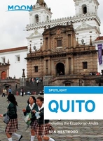
Quito: Including The Ecuadorian Andes Spotlight Guide

”Moon Spotlight Quito” is a 115-page compact guide covering Ecuador`s capital city and highlights of the surrounding Andes. Seasoned traveler and journalist Ben Westwood offers his firsthand advice on must-see attractions, as well as maps with sightseeing highlights, so you can make the most of your time. This lightweight guide is packed with recommendations on entertainment, shopping, recreation, hotels, food, and transportation, making navigating this diverse area uncomplicated and enjoyable. This Spotlight guidebook is excerpted from ”Moon Ecuador & the Galapagos Islands.”
RIP - This product is no longer available on our network. It was last seen on 25.09.2019

This page now acts as a permanent archive for this product. Add more information using the comments box below to ensure it can still be found by future generations.

Use our search facility to see if it is available from an alternative contributor.
  • Availability: Out Of Stock
  • Supplier: Stanfords
  • SKU: 9781631210358
Availability: In Stock
£7.99

Product Description

” Moon Spotlight Quito” is a 115-page compact guide covering Ecuador`s capital city & highlights of the surrounding Andes. Seasoned traveler & journalist Ben Westwood offers his firsthand advice on must-see attractions, as well as maps with sightseeing highlights, so you can make the most of your time. This lightweight guide is packed with recommendations on entertainment, shopping, recreation, hotels, food, & transportation, making navigating this diverse area uncomplicated & enjoyable. This Spotlight guidebook is excerpted from ” Moon Ecuador & the Galapagos Islands.”

Reviews/Comments

Add New

Intelligent Comparison

Oooops!
We couldn't find anything!
Perhaps this product's unique.... Or perhaps we are still looking for comparisons!
Click to bump this page and we'll hurry up.

Price History

Vouchers

No voucher codes found.
Do you know a voucher code for this product or supplier? Add it to Insights for others to use.

Facebook

Jargon Buster

Ecuador - A country in South America next to the Pacific Ocean
compact - Carefuly designed to ensure an item has a minimal physical size
Entertainment - Something that provides amusement
Compact - something that has a lot combined within a small space.

Supplier Information

Stanfords
Stanfords was established in 1853 and opened their iconic Covent Garden flagship store in 1901. They have become the top retailer of maps, travel books and accessories in the UK and arguably offer the largest selection of maps and travel books worldwide. Famous names such as Captain Robert Falcon Scott, Ranulph Fiennes and Michael Palin have purchased from Stanfords. They now have a shop in Bristol and both stores together with other venues operate a calendar of events including talks, book signings and exhibitions. As a specialist map retailer, the map selection is comprehensive and includes road maps, street maps and walking maps from worldwide destinations, as well as a selection of world atlases and wall maps. Books include travel guides and travel literature. Stanfords also stock globes, from miniatures made of blue marble to magnificent floor-standing globes. The website features a selection of interesting articles on travel topics.
Page Updated: 2023-11-12 20:15:36

Community Generated Product Tags

Oh No! The productWIKI community hasn't generated any tags for this product yet!
Menu