More From Contributor
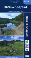
£16.99
A stunning debut in the tradition of Robert Macfarlane & Helen Macdonald Of all the birds of the British Isles, the raptor ...
Archived Product
£9.99
Winner of The Royal Society of Literature Jerwood Award for Non-Fiction in 2011 & the Authors` Foundation Roger Deakin Award in 2011A stunning debut in the tradition of Robert Macfarlane & Helen Macdonald Of all the birds of the British Isles, the raptor reigns supreme, sparking the imagination like no other. In this magnificent hymn to these beautiful animals, James Macdonald Lockhart explores all fifteen breeding birds of prey on these shores
- from the hen harrier swimming over the land in the dregs of a May gale on Orkney, to the ghostly sparrowhawk displaying in the fields around his home in Warwickshire. This is a book that will change how we think of our own skies.
...
Archived Product
£32.95
The essential field guide to the raptors of Mexico & Central America Raptors are among the most challenging birds to identify in the field due to their bewildering variability of plumage, flight silhouettes, & behavior. Raptors of Mexico & Central America is the first illustrated guide to the region`s 69 species of raptors, including vagrants. It features 32 stunning color plates & 213 color photos, & a distribution map for each regularly occurring species. Detailed species accounts describe key identification features, age-related plumages, status & distribution, subspecies, molt, habitats, behaviors, potential confusion species, & more. Raptors of Mexico & Central America is the essential field guide to this difficult bird group & the ideal travel companion for anyone visiting this region of the world.* Covers all 69 species of raptors found in Mexico & Central America* Features 32 color plates & hundreds of color photos* Provides multiple illustrations of each species* Depicts & describes variations in plumage by individual, morph, age, & region* Describes behavior, food preferences, hunting strategies, vocalizations, & molt* Covers rare & extralimital species*

Includes::
distribution maps & flight silhouettes

...
Archived Product
£12.95
The draft dodger Laurence yearns to take control of his destiny. Having fled to the highlands, he asserts his independence by committing a string of robberies & murders. Then he happens upon Ivlita, a beautiful young woman trapped in an intricately carved mahogany house. Laurence does not hesitate to take her as well. Determined to drape his young bride in jewels, he plots ever more daring heists. Yet when Laurence finds himself casting bombs alongside members of a revolutionary cell, he must again ask: is he a free man or a pawn of history? Rapture is a fast-paced adventure-romance & a literary treat of the highest order. With a deceptively light h&, Iliazd entertains questions that James Joyce, Virginia Woolf, & Thomas Mann once faced. How does the individual balance freedom & necessity, love & death, creativity & sterility? What is the role of violence in human history & culture? How does language both comfort & fail us in our postwar, post-Christian world? Censored for decades in the Soviet Union, Rapture was nearly lost to Russian & Western audiences. This translation rescues Laurence`s surreal journey from the oblivion he, too, faces as he tries to outrun fate. ...
Archived Product
£5.99
The classic story of Rapunzel gets a fresh twist in this vibrant Indian spin on the beloved fairy tale! Once upon a time, there was a girl with long, long hair, who lived in a tall, tall tower... The classic tale of Rapunzel gets a fresh twist in this third book of a br&-new board book series, Once Upon a World. With India as the backdrop, & vibrant artwork from illustrator Archana Sreenivasan, Rapunzel is still the same girl who lets down her beautiful hair-but she`s totally reimagined. Once Upon a World offers a multicultural take on the fairy tales we all know & love. Because these tales are for everyone, everywhere. ...
Archived Product
£18.95
Rara, Jumla & Mugu region in the Newgrove Consultants’ series covering the course of Great Himalaya Trail High Route at 1:100, 000 on nine maps printed on light, waterproof & tear-resistant plastic paper. The map is double-sided, with a very generous overlap between the sides, & covers the High Route between Malchham north of the Rara Lake & the Rara National Park & Crystal Mountain in the Shey-Phoksundo National Park. The base map, derived from satellite imagery, has contours at 200m intervals enhanced by relief shading & colouring to show glaciers, the snow line at 6000m, barren l&, forests, etc. Numerous spot heights are marked in the high-laying areas, but not very many & in places none on the south side of the trail. Important peaks & mountain passes are prominently marked. Boundaries of national parks & other protected areas are also shown. The High Route of the GHT is clearly highlighted & adjoining local routes are divided into main trails & footpaths. Icons indicate locations of campsites & hotels/lodges, health posts, stupas, gompas & mani walls both along the GHT itself & in other locations on the map. Settlements are graded into large towns, towns, villages & small villages. The maps have latitude & longitude lines at intervals of 5’. All information is in English. Seven of the maps are double-sided, with the last three maps covering the easternmost part of the country from Rolwaling Himal & Mt Everest to Kanchenjunga on single-sided maps. PEASE NOTE: Sheet No. 1, Far West, covers an area outside the course of the High Route. It shows the route of the Lower Great Himalaya Trail. According to the publishers’ notes: “ The maps have been created & published by Newgrove Consultants on behalf of The Great Himalaya Trail Development Programme which is funded by the UK Department for International Development & managed by SNV Netherland’s Development Organization. United Nations World Tourism Organization through its “ Sustainable Tourism – Eliminating Poverty” programme ahs played a key role in bringing the project into fruition. The maps are based on data from the National Geographic Information Infrastructure Programme (NGIIP) of Nepal. The International Centre for Integrated Mountain Development (ICIMOD) also provided low scale data. Trekkers & guides have been consulted on current routes.” ...
Archived Product
£9.99
Rarau-Giumalau Mountains & Bucovina Monasteries at 1:70, 000 in a series of detailed contoured maps covering popular hiking areas of Transylvania published by Dimap, one of Hungary’s leading publishers specializing in mapping of that region. The maps show local hiking routes & provide tourist information such as campsites, places of interest, etc. Many titles include street plans and/or English language descriptions of recommended hiking trails.* In this title:* hiking map with contours at 20m intervals showing local footpaths with their waymarking. Symbols indicate various types of accommodation including campsites & shelters, places of interest, petrol stations, etc. The map prominently highlights locations with historical monasteries. Latitude & longitude lines are drawn at 1` intervals. On the reverse are black & white street plans of city centres in Suceava, Campulung
- Moldovenesc & Vatra Dornei, plus notes describing six sightseeing tours & 18 local hiking trails. * Map legend & all the notes include English.*
...
Archived Product
£14.99
Rare presents an exquisite collection of stark & haunting studio images of the most endangered or imperiled plants & animals of North America. Renowned National Geographic photographer Joel Sartore has devoted years to making these photographs & documenting more than 1, 200 imperiled species. Here are his favorites, highlighted with his stories about taking photographs of wild animals in controlled settings. A selection of these images was published in National Geographic Magazine in January 2009, to great acclaim. The book gives an opportunity to present those pictures bigger, in greater detail, & to add in others
- both from Sartore's archive & from those he has taken in the year since. Every one is an exquisite work of art, & together they form a repository of mammals, birds, reptiles, amphibians, fish, & flowers that few of us will see
- & even fewer of our children will see. There is bad & good news in this book. The bad news is that the last individuals representing some of these species, like the pygmy rabbit, have died since Sartore took their photographs. The good news is that some species, like the American bald eagle, are in fact increasing now in the wild, thanks to the effects of Congress' Endangered Species Act & the work of bird & animal lovers & environmentalists. All such stories are told, in brilliant pictures & a few well-chosen words, in Joel Sartore's work of a lifetime, Rare.

...
Archived Product
£18.99
” Rare, Wild & Free” is a testament to the work of one of the finest nature writers Britain has ever produced
- Mike Tomkies,
...
Archived Product
£12.99
Map No. 1288, Raron, in the topographic survey of Switzerland at 1:25, 000 from Bundesamt für Landestopographie (swisstopo), covering the whole country on 247 small format sheets, with special larger maps published for popular regions including some titles now available in hiking versions. Highly regarded for their superb use of graphic relief & hill shading, the maps give an almost 3-D picture of Switzerland`s mountainous terrain. Contours are at 10 m intervals, with 20m intervals in the mountainous areas. All the maps have a 1-km grid for Swiss national coordinates (datum CH 1903). * Small format sheets (Nos. 1011
- 1374)* Map legend in the language of the area covered by the map. Additional margin ticks show latitude & longitude in steps of 2`. The area covered by each map is 17 x 12 km (11 x 7 miles approx). * Special larger sheets (Nos. from 2501 onwards) – STANDARD editions:* No map legend is included but a separate leaflet can be provided instead. The area covered by each map is 25 x 17 km (15 x 11 miles approx).* Special larger sheets (Nos. from 2501 onwards) – HIKING editions:* An overprint highlights hiking, mountain & alpine paths, including regional & national long-distance trails. The maps also show bus routes with bus stops, plus inns in remote locations. The area covered by each map is 25 x 17 km (15 x 11 miles approx).
...
Archived Product

Rara To Khaptad

Trekking routes in Nepal west of Jumla on a contoured and GPS-compatible map at 1:150, 000 from Nepa Maps. Coverage extends westwards from Jumla, Rara Lake and the Rara National Park to Silgadhi and Dipayal. The trail from Rara Lake westwards to the Khaptad Camp, Khaptad National Park and then north to Tamil is prominently highlighted, with other trekking routes in the region also clearly marked.The map has contours at 80m intervals, enhanced by relief shading and colouring/graphics to show forested areas, cultivated land, etc. Main trekking trails are highlighted, as are important settlements and locations with tourist accommodation including campsites, medical facilities, banks and internet cafes, religious sites, etc. Latitude and longitude are shown by margin ticks at 5’
intervals. The index lists places, passes and lakes. Map legend includes English.To see other titles in this series please click in the series link.
RIP - This product is no longer available on our network. It was last seen on 25.09.2019

This page now acts as a permanent archive for this product. Add more information using the comments box below to ensure it can still be found by future generations.

Use our search facility to see if it is available from an alternative contributor.
  • Availability: Out Of Stock
  • Supplier: Stanfords
  • SKU: 9789937577748
Availability: In Stock
£17.99

Product Description

Trekking routes in Nepal west of Jumla on a contoured & GPS-compatible map at 1:150, 000 from Nepa Maps. Coverage extends westwards from Jumla, Rara Lake & the Rara National Park to Silgadhi & Dipayal. The trail from Rara Lake westwards to the Khaptad Camp, Khaptad National Park & then north to Tamil is prominently highlighted, with other trekking routes in the region also clearly marked. The map has contours at 80m intervals, enhanced by relief shading & colouring/graphics to show forested areas, cultivated l&, etc. Main trekking trails are highlighted, as are important settlements & locations with tourist accommodation including campsites, medical facilities, banks & internet cafes, religious sites, etc. Latitude & longitude are shown by margin ticks at 5’ intervals. The index lists places, passes & lakes. Map legend

Includes::
English. To see other titles in this series please click in the series link.

Reviews/Comments

Add New

Intelligent Comparison

Oooops!
We couldn't find anything!
Perhaps this product's unique.... Or perhaps we are still looking for comparisons!
Click to bump this page and we'll hurry up.

Price History

Vouchers

No voucher codes found.
Do you know a voucher code for this product or supplier? Add it to Insights for others to use.

Facebook

Jargon Buster

GPS - Global Positioning System - Global position using satellites
Graphics - A general term for visual aspects of an item/display
Accommodation - A room in which someone can live in, for example in a hotel

Supplier Information

Stanfords
Stanfords was established in 1853 and opened their iconic Covent Garden flagship store in 1901. They have become the top retailer of maps, travel books and accessories in the UK and arguably offer the largest selection of maps and travel books worldwide. Famous names such as Captain Robert Falcon Scott, Ranulph Fiennes and Michael Palin have purchased from Stanfords. They now have a shop in Bristol and both stores together with other venues operate a calendar of events including talks, book signings and exhibitions. As a specialist map retailer, the map selection is comprehensive and includes road maps, street maps and walking maps from worldwide destinations, as well as a selection of world atlases and wall maps. Books include travel guides and travel literature. Stanfords also stock globes, from miniatures made of blue marble to magnificent floor-standing globes. The website features a selection of interesting articles on travel topics.
Page Updated: 2023-11-12 20:15:36

Community Generated Product Tags

Oh No! The productWIKI community hasn't generated any tags for this product yet!
Menu