
 United Kingdom
 France
 Germany
 Netherlands
 Sweden
 USA
USA
 Italy
Italy
 Spain
Spain
More From Contributor


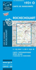


Rochdale South West And Sudden 1908
Rochdale South West and Sudden in 1908 in a fascinating series of reproductions of old Ordnance Survey plans in the Alan Godfrey Editions, ideal for anyone interested in the history of their neighbourhood or family. The map covers the south-western area of Rochdale, including the hamlets of Sudden and Marland. Coverage stretches from Freehold Street westward to Heywood Cemetery, and from Sporth Mill southward to Crest Mill. Features include Union Ring Mill, Valley Ring Mill, Castleton Grange, Castleton Gates, Gorrels Farm, a short stretch of the Rochdale Canal, Castleton Lower Mill, Castleton House, Marland Grange, Sudden, River Roch, Marland Hospital, Chamber House, Broadhalgh Mill, etc. On the reverse is a large extract of Six inch to the Mile sheet 88NE, providing
coverage of a wider area including Bamford, Broadhalgh, Bagslate Moor, Cutgate, Crimble and western Rochdale. About the Alan Godfrey Editions of the 25” OS Series:Selected towns in Great Britain and Ireland are covered by maps showing the extent of urban development in the last decades of the 19th and early 20th century. The plans have been taken from the Ordnance Survey mapping and reprinted at about 15 inches to one mile (1:4, 340). On the reverse most maps have historical notes and many also include extracts from contemporary directories. Most maps cover about one mile (1.6kms) north/south, one and a half miles (2.4kms) across; adjoining sheets can be combined to provide wider coverage.FOR MORE INFORMATION AND A COMPLETE LIST OF ALL AVAILABLE TITLES PLEASE CLICK ON THE SERIES
LINK.

Product Description
Reviews/Comments
Add New
Vouchers
No voucher codes found.
Do you know a voucher code for this product or supplier? Add it to Insights for others to use.
Do you know a voucher code for this product or supplier? Add it to Insights for others to use.
 Denmark