
 United Kingdom
 France
 Germany
 Netherlands
 Sweden
 USA
USA
 Italy
Italy
 Spain
Spain
More From Contributor


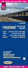
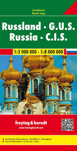
Russia - C. I. S. F&B
Detailed, double-sided road map with Russia on one side and the C. I. S. (Commonwealth of Idependent States) on the other. The Russian side clearly shows the national road network and selected provincial and local roads, with each class of road clearly indicated and road numbers shown. Intermediate driving distances between locations are shown in kilometres alongside the road, motorway filling stations are shown and motorway junctions are indicated.Topography is shown with relief shading and some spot heights, and colour shading is used to indicate land types. International and provincial boundaries are clearly marked, as are National Parks, nature reserves and restricted military areas. Symbols indicate various sights & locations of tourist interest, such as mosques are clearly
marked. Railway lines, oil fields, airports etc. are also clearly marked.The C. I. S. side shows international boundaries, population centres, navigatable canals, lakes, ports and railways. Politcal colouring is also used to discern national boundaries. A grid divides the Russian map at 1° increments, whilst the C. I. S. side has a grid divided at 12° (latitude) and 8° (longitude) - the Russian map is grid-referenced and fully indexed.*Multilingual map legend includes English.*
marked. Railway lines, oil fields, airports etc. are also clearly marked.The C. I. S. side shows international boundaries, population centres, navigatable canals, lakes, ports and railways. Politcal colouring is also used to discern national boundaries. A grid divides the Russian map at 1° increments, whilst the C. I. S. side has a grid divided at 12° (latitude) and 8° (longitude) - the Russian map is grid-referenced and fully indexed.*Multilingual map legend includes English.*

Product Description
Reviews/Comments
Add New
Vouchers
No voucher codes found.
Do you know a voucher code for this product or supplier? Add it to Insights for others to use.
Do you know a voucher code for this product or supplier? Add it to Insights for others to use.
 Denmark