
 United Kingdom
 France
 Germany
 Netherlands
 Sweden
 USA
USA
 Italy
Italy
 Spain
Spain
More From Contributor

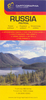
Russia
Medium-sized 77x60cm political map with the country borders in different colours on a white background showing Russia, the other neighbouring countries in the Commonwealth of Independent States, and the Baltic & Scandinavian states. The map also shows provincial borders within Russia. Major roads, railways and water features are marked, along with a large number of towns, and mountain ranges are shown by subtle shading. A small range of symbols depict airports, canals, oil pipelines & oilfields.
Product Description
Reviews/Comments
Add New
Intelligent Comparison
Archived Product

Russia Stanfords
£8.99
Archived Product
Russia Stanfords
£15.99
Archived Product
Russian Stanfords
£4.99
Archived Product
Mussidan Stanfords
£11.50
Archived Product
Russia West Stanfords
£9.95
Archived Product
Russia ITMB Stanfords
£9.99
Vouchers
No voucher codes found.
Do you know a voucher code for this product or supplier? Add it to Insights for others to use.
Do you know a voucher code for this product or supplier? Add it to Insights for others to use.
 Denmark