More From Contributor

£6.95
Topographic coverage of mainland Spain at 1:50, 000 in the MTN50 (Mapa Topográfico Nacional) series from the Centro Nacional de Información Geografica, the country’s civilian survey organization. The maps have contours at 20m intervals, enhanced by relief shading, plus colouring and/or graphics to show different types of terrain, vegetation or land use. Boundaries of national parks & other protected areas are marked. In addition to all the usual information featured on topographic mapping at this scale, detailed presentation of the road & rail networks, rural tracks & paths, etc, the maps also show campsites & mountain refuges. On more recent editions some GRs, the official long-distance hiking routes, are also marked (although not as clearly as on hiking maps from other publishers). Each map covers 29.5x 18.5 km (with adjustments in the border or coastal areas). The maps have a 1-km UTM grid, plus margin ticks for latitude & longitude at 1` intervals. Map legend is in Spanish only.HOW TO CHOOSE THE RIGHT 50K MAP: all the titles in CNIG’s 200K Provincial Road Maps series at 1:200, 000 are overprinted with the grid for the 1:50, 000 maps & can be used to see the area covered by each 50K title. TO SEE THE LIST OF TITLES IN THIS SERIES PLEASE CLICK ON THE SERIES LINK.PLEASE NOTE
- MAP TITLES: the grids shown on our website serve both the civilian & the military 1:50, 000 topographic series. Although the areas covered by maps in both series are identical (apart from some border or coastal sheets), occasionally map titles differ – only one title is shown on the grid, usually the military one. In Galicia, the Basque country & in the Catalan speaking areas the tendency now is to use local place names rather than the often better known Castilian ones. Where possible, both versions are included in our titles. Map titles listed on our website are based on information received by us at the time of publication, but sometimes maps arrive showing a completely different title! As long as the map number is as ordered, the correct map has been supplied.
...
Archived Product
£6.50
Topographic coverage of mainland Spain at 1:25, 000 published by the Centro Nacional de Información Geograficá, the country’s civilian survey organization. The maps have contours at 10m intervals & colouring and/or graphics to show different types of vegetation or land use. Boundaries of national parks & other protected areas are marked. In addition to all the usual information shown on topographic maps at this scale, detailed presentation of the road & rail networks, rural tracks & paths, etc, the maps also show campsites. The maps have a 1-km UTM grid, with margin ticks for latitude & longitude at 1` intervals. Map legend is in Spanish only.PLEASE NOTE: our grid for the whole of Spain is in preparation
- in the meantime, for areas other than those shown on the attached grid please use CNIG’s topographic survey at 1:50, 000 by searching for ‘SI00000832’. Each 25K map covers one quarter of the corresponding 50K map, with the numbering system: I = NW quarter, II = NE quarter, III = SW quarter & IV = SE quarter. CNIG maps in the Provincial Road Maps series at 1:200, 000 are overprinted with the grid for the 1:50, 000 survey & can be used to see the area covered by each 50K or 25K title in more detail. To see the list of titles in this series please click on the series grid
- for map numbers not yet listed on our website please contact us by email.

...
Archived Product
£14.99
The concept behind the Ruth & Martin`s Album Club blog is simple: Make people listen to a classic rock album they`ve never heard before. Make them listen to it two more times. Get them to explain why they never bothered with it before. Then ask them to review it. What began as a simple whim quickly grew in popularity, & now Ruth & Martin`s Album Club has featured some remarkable guests: Ian Rankin on Madonna`s Madonna. Chris Addison on Marvin Gaye`s What`s Going On. Brian Koppelman on The Smiths` Meat is Murder. JK Rowling on the Violent Femmes` Violent Femmes. Bonnie Greer on The Beach Boys` Pet Sounds. Martin Carr on Paul Mc Cartney`s Ram. Brian Bilston on Neil Young`s Harvest. Anita Rani on The Strokes` Is This It. Richard Osman on Roxy Music`s For Your Pleasure. & many, many more. Each entry features an introduction to each album by blog creator Martin Fitzgerald. What follows are delightful, humorous & insightful contributions from each guest as they have an album forced upon them &
- for better or worse
- they discover some of the world`s favourite music. Ruth & Martin`s Album Club is a compilation of some of the blog`s greatest hits as well as some exclusive material that has never appeared anywhere before. Throughout, we get an insight into why some people opt out of some music, & what happens when you force them to opt in.

...
Archived Product
£12.99
In a world that witnessed the emergence of automatic timeballs, telegraph time signals, the speaking clock, & the BBC`s ”six pips, ” one family provided the hours & minutes to paying customers across London for more than 100 years using a pocketwatch named ” Arnold.” It was with Ruth Belville--the last of the timesellers, who retired in her 80s in 1939--that this remarkable episode in the history of timekeeping & London life was brought to a close. Seeking to show that the Belvilles operated a service that was to many customers better than the official electric time signals from Greenwich, this chronicle turns the story of the Greenwich Time Service on its head, revealing for the first time the strengths of Ruth Belville & her family. In this fascinating true account, commercial propaganda, dirty tricks, & failing technologies come together in a story of the Greenwich Time Lady & her surefire will to succeed in Edwardian London. ...
Archived Product
£3.50
Rutherglen East 1910 in a fascinating series of reproductions of old Ordnance Survey plans in the Alan Godfrey Editions, ideal for anyone interested in the history of their neighbourhood or family. The map covers the eastern half of Rutherglen. Coverage stretches from the Town Hall & Regent Street eastward to Hamilton Farm & the Clyde, & from Cowtown southward to Rosslyn Avenue. Features include the Caledonian Railway with station, sidings, Clydebridge Junction, Rutherglen Junction & goods station; Eastfield, Eastfield Quarry, Ballochmill, Flock Factory, Clydebridge Steel Works, Easterhill Colliery, Easterhill House, Parkhead Reformatory, Gallowflat House, Clincarthill, Wardlawhill, Caledonian Pottery, Old Farme, Farme Branch, Rutherglen Rope Works, etc. On the reverse is a Rutherglen directory, entries M to Z. About the Alan Godfrey Editions of the 25” OS Series: Selected towns in Great Britain & Ireland are covered by maps showing the extent of urban development in the last decades of the 19th & early 20th century. The plans have been taken from the Ordnance Survey mapping & reprinted at about 15 inches to one mile (1:4, 340). On the reverse most maps have historical notes & many also include extracts from contemporary directories. Most maps cover about one mile (1.6kms) north/south, one & a half miles (2.4kms) across; adjoining sheets can be combined to provide wider coverage.FOR MORE INFORMATION & A COMPLETE LIST OF ALL AVAILABLE TITLES PLEASE CLICK ON THE SERIES LINK. ...
Archived Product
£2.95
Ruthin in 1910 in a fascinating series of reproductions of old Ordnance Survey plans in the Alan Godfrey Editions, ideal for anyone interested in the history of their neighbourhood or family. Selected towns in Great Britain & Ireland are covered by maps showing the extent of urban development in the last decades of the 19th & early 20th century. In this title: the map covers the small market town & borough of Ruthin. Features include the town centre, Mineral Water Works, Ruthin Castle, railway & station, Well Street, Workhouse, auction mart, Grammar School, Pont Howkin. The map extends west along Clwyd Street & Mwrog Street to Llanfwrog & St Mwrog's church. Part of Castle Park is included; River Clwyd runs south-north through the map. On the reverse is an Alphabetical Arrangement of Residents, Traders & Others from an 1890 directory. About the Alan Godfrey Editions of the 25 ...
Archived Product
£5.95
Rutland in a series of colourful reproductions of attractive county maps by John Speede from about 1610-1611, printed on thick art paper & ideal for framing. Each title, 58 x 45cm / approx. 23” x 18”, is decorated with additional notes, drawings, coats of arms, street plans, etc. Little drawings are used to show locations of towns, larger villages, hills & woodlands or parks. Rivers & lakes are also drawn, as are boundaries of the administrative subdivisions with the names of the Hundreds. Surrounding the county are decorative panels filled with additional information which differs from title to title: street plans, coats of arms of notable local families, geographical features, notes about local history, etc. ...
Archived Product
£2.95
Rutland 1610 Replica Map by the Old Map Company is a reproduction of the map created for the famous atlas of the period by the master map maker John Speede Esq. The Old Map Company has recreated the antique maps of British counties, European cities & World countries originally crafted by master map maker John Speede Esq. whose work had accuracy & quality not surpassed for centuries. Each map is treated & presented on specially crafted paper then h&-treated giving it texture & an aged appearance before being beautifully engraved & detailed. ...
Archived Product
£140.00
Rutlandshire Divided Into Its Hundreds.. ., an original antique map by J. Ellis, published in London 1765-1768. A copperplate engraving, original o/l colour. Map size 19 x 24.5 cm, overall mounted size 34.5 x 40.5 cm. An attractive map of the county complete with the major roads. Borough towns are shown with stars identifying the number of members returned to parliament & Places where Fairs are kept have a Line under the Name thus. Ellis (d.1796) was a prolific English engraver of the late eighteenth century who joined with William Palmer to produce a set of English county maps, published in Ellis' New English Atlas, in 1765. The maps were later used in Ellis' English Atlas; or a Complete Cartography of England & Wales published in 1766, & reprinted in 1768
- this map comes from the 1768 edition. Ellis engraved some of the maps himself, while others were engraved by Louis de la Rochette, Palmer & W. Fowler. The maps themselves were closely based on Kitchin's maps from Dodsley's England Illustrated. Ellis' atlases were very popular, being often reprinted, as the maps are clearly & distinctively engraved with decorative title cartouches. Antique maps from various original publishers are presented on the Stanford
...
Archived Product
£60.00
Rutlandshire an original antique map by G. Cole / J. Roper published in London, 1810-1843. Copperplate, coloured. Map size 17 x 23 cm, overall mounted size 32.5 x 38.5 cm. This detailed map of Rutland is from Dugdale's England & Wales Delineated. The map was drawn by G. Cole & engraved by John Roper for publication first in The Beauties Of England & Wales, issued in parts, from c.1804. Such was the success of the publication that the maps were re-used in other publications, as here. The maps show accurate geographical detail, including the turnpike, mail coach & principal roads, sites of Roman & other historical remains, as well as the seats of the nobility & the gentry, & market towns with their distances from London. The maps also show the division of the counties into hundreds or wapontakes. They are representative of the functional nineteenth-century approach to cartography, yet are not unattractive. Antique maps from various original publishers are presented on the Stanford ...
Archived Product

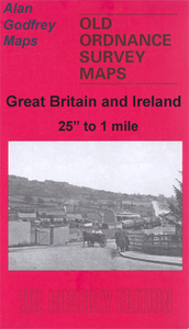
Rutherglen West And Polmadie 1910

Rutherglen West and Polmadie 1910 in a fascinating series of reproductions of old Ordnance Survey plans in the Alan Godfrey Editions, ideal for anyone interested in the history of their neighbourhood or family. The map covers the western half of Rutherglen, plus the Polmadie area of south Glasgow. Coverage stretches from Hampden Park eastward to Queen Street Rutherglen. Features include the western part of Rutherglen Main Street, tramways, Cathcart Street, Burnside Factory, Govan Colliery Pits 5 and 6, Blackfaulds, Shawfield Brick Works, Polmadie Mineral Depot, engine shed, Aikenhead Road, Govan Colliery Depot, Aikenhead Colliery Pits 1 and 2, Hangingshaw, Hampden Park football ground, White`s soap works, etc. On the reverse is a Rutherglen directory, entries A to M.About
the Alan Godfrey Editions of the 25” OS Series:Selected towns in Great Britain and Ireland are covered by maps showing the extent of urban development in the last decades of the 19th and early 20th century. The plans have been taken from the Ordnance Survey mapping and reprinted at about 15 inches to one mile (1:4, 340). On the reverse most maps have historical notes and many also include extracts from contemporary directories. Most maps cover about one mile (1.6kms) north/south, one and a half miles (2.4kms) across; adjoining sheets can be combined to provide wider coverage.FOR MORE INFORMATION AND A COMPLETE LIST OF ALL AVAILABLE TITLES PLEASE CLICK ON THE SERIES LINK.
RIP - This product is no longer available on our network. It was last seen on 25.09.2019

This page now acts as a permanent archive for this product. Add more information using the comments box below to ensure it can still be found by future generations.

Use our search facility to see if it is available from an alternative contributor.
  • Availability: Out Of Stock
  • Supplier: Stanfords
  • SKU: 9781841513102
Availability: In Stock
£3.50

Product Description

Rutherglen West & Polmadie 1910 in a fascinating series of reproductions of old Ordnance Survey plans in the Alan Godfrey Editions, ideal for anyone interested in the history of their neighbourhood or family. The map covers the western half of Rutherglen, plus the Polmadie area of south Glasgow. Coverage stretches from Hampden Park eastward to Queen Street Rutherglen. Features include the western part of Rutherglen Main Street, tramways, Cathcart Street, Burnside Factory, Govan Colliery Pits 5 & 6, Blackfaulds, Shawfield Brick Works, Polmadie Mineral Depot, engine shed, Aikenhead Road, Govan Colliery Depot, Aikenhead Colliery Pits 1 & 2, Hangingshaw, Hampden Park football ground, White`s soap works, etc. On the reverse is a Rutherglen directory, entries A to M. About the Alan Godfrey Editions of the 25” OS Series: Selected towns in Great Britain & Ireland are covered by maps showing the extent of urban development in the last decades of the 19th & early 20th century. The plans have been taken from the Ordnance Survey mapping & reprinted at about 15 inches to one mile (1:4, 340). On the reverse most maps have historical notes & many also include extracts from contemporary directories. Most maps cover about one mile (1.6kms) north/south, one & a half miles (2.4kms) across; adjoining sheets can be combined to provide wider coverage.FOR MORE INFORMATION & A COMPLETE LIST OF ALL AVAILABLE TITLES PLEASE CLICK ON THE SERIES LINK.

Reviews/Comments

Add New

Intelligent Comparison

Oooops!
We couldn't find anything!
Perhaps this product's unique.... Or perhaps we are still looking for comparisons!
Click to bump this page and we'll hurry up.

Price History

Vouchers

No voucher codes found.
Do you know a voucher code for this product or supplier? Add it to Insights for others to use.

Facebook

Jargon Buster

Contemporary - Modern era design
Engine - A machine designed to convert fuel into motion
Contemporary - A design reference to indicate post war modern design
White - A colour combining all colours
Football - A sport involving kicking a ball and trying to score a goal
soap - The salt of a fatty acid used for cleaning and as a component of lubricants.
mineral - A naturally occurring solid chemical substance.
History - Anything that happens in the past. An acedemic subject.
Road - a manmade lane or a path that is used to speed up travel.
Contemporary - An object that is living in the same time.
Ideal - Something that satisfies a perfect criteria.
Family - A group of people that live together made up from parents and children.

Supplier Information

Stanfords
Stanfords was established in 1853 and opened their iconic Covent Garden flagship store in 1901. They have become the top retailer of maps, travel books and accessories in the UK and arguably offer the largest selection of maps and travel books worldwide. Famous names such as Captain Robert Falcon Scott, Ranulph Fiennes and Michael Palin have purchased from Stanfords. They now have a shop in Bristol and both stores together with other venues operate a calendar of events including talks, book signings and exhibitions. As a specialist map retailer, the map selection is comprehensive and includes road maps, street maps and walking maps from worldwide destinations, as well as a selection of world atlases and wall maps. Books include travel guides and travel literature. Stanfords also stock globes, from miniatures made of blue marble to magnificent floor-standing globes. The website features a selection of interesting articles on travel topics.
Page Updated: 2023-11-12 20:15:36

Community Generated Product Tags

Oh No! The productWIKI community hasn't generated any tags for this product yet!
Menu