More From Contributor

£12.99
West Cork is a place apart, with its unique combination of ?ora, fauna, history & landscape, & is quietly explored by large numbers of visitors annually. This guide to some of the best low-level walks in the region has clear descriptions & engaging commentaries on natural & human history to enhance the walker`s enjoyment & appreciation of the routes. From the scenic interior to spectacular coastal scenery & islands, these cross-country, road & waterside excursions have something for everyone. Walks vary from 1.5km strolls to a 13km traverse of Sherkin Isl&. The author has put his considerable experience & knowledge of the area to great use in this evocative guide, which introduces the best of the area. Each route has a sketch map & colour photographs to illustrate the beauty of the landscape, its wild creatures, wild ? owers & built heritage. Ferry & cable-car timetables are included. This is a treasury of information to take readers on the ways less travelled. ...
Archived Product
£9.99
Although this has been the inspiration for two popular films, ” Scent of a Woman” is a great read in it`s original form, a comfortably far cry from the ”hoo-ha” of Pacino & the Hollywood tale it came to be. Two soldiers travel across Italy at the height of summer, passing through Genoa, Rome & Naples. One of the soldiers is blind, graceful, gleefully vicious & wears a prosthetic arm; the other, twenty years his junior, is his guide. But as these men drink their way through bars, brothels & train carriages, who is guiding who? Only as they reluctantly approach the blind man`s destination, & a stifled love affair, does the purpose of the trip become tragically clear.” Scent of a Woman” is a lyrical exploration of regret, defiance, & what it really means to see. ...
Archived Product
£6.99
This selection of 6 mini scented highlighters from NPW

Includes::
6 neon coloured highlighters, each with

...
Archived Product
£9.99
We might not like to admit to it, but everyone
- even the gentlest of souls
- derives a secret guilty satisfaction from the

...
Archived Product
£9.99
Schadenfreude
- enjoying the pain & failures of others
- is an all-too-familiar feeling. It has perplexed philosophers & psychologists

...
Archived Product
£9.99
Schadminger Tauern
- Radstadt
- Dachstein
- Schladming area of the Austrian Alps presented at 1:50, 000 in a series of contoured


...
Archived Product
£19.99
Schaffhausen area at 1:50, 000 in a series from Hallwag covering Switzerland’s popular hiking regions on light, waterproof & tear-resistant maps highlighting long-distance paths: the nine national routes plus special regional routes, as well as other local hiking trails. Cartography is similar to that used both in Hallwag’s hiking atlases & in the walking series from Kümmerly + Frey at 1:60, 000 covering the whole country. The maps have contours at 50m or 25m intervals according to the terrain, enhanced by graphic relief & shading. A special feature of this series is an overprint indicating the nine national long-distance routes, plus regional long-distance trails. The overprint also shows other local paths, distinguishing between sign-posted hiking paths, mountain paths where proper walking shoes are necessary, & alpine paths requiring special equipment for glacier traverses & light climbing. Mountain huts are marked, plus various types of accommodation: campsites, youth hostels, “ Friends of Nature” houses, & secluded hotels & restaurants. Road network indicates local bus routes with stops. Railways, narrow gauge mountain railways, cable car lines, & chair lifts are shown, with various symbols highlighting places of interest, viewpoints, picnic sites, swimming pools, etc. The maps have a 1km grid for Swiss national coordinates (datum CH1903 Bessel), with latitude & longitude shown as margin ticks at 5’. * Map legend

Includes::
English.* On the reverse, an index of towns & villages

Includes::
names of geographical features such as mountains, alpine passes, glaciers, lakes, rivers, as well as places of interest. Also provided is a small road map at 1:301, 000 of a wider region around the area covered by each title.


...
Archived Product
£18.99
Schaffhausen
- Stein am Rhein area, map No. 405T, at 1:50, 000 in a special hiking edition of the country’s topographic survey,
...
Archived Product
£19.99
Schaffhausen
- Winterthur area at 1:60, 000 in Kümmerly + Frey’s series of cycling maps published in co-operation with the Association
...
Archived Product
£19.99
Schaffhausen
- Winterthur area at 1:60, 000 in Kümmerly + Frey’s hiking series of Switzerl&, with most titles now printed on
...
Archived Product

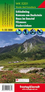
Schadming - Ramsau Am Dachstein - Haus Im Ennstal - Filzmoos -
Stoderzinken F&B WK5201

Schadming - Ramsau am Dachstein - Haus im Ennstal - Filzmoos - Stoderzinken area of the Austrian Alps presented at 1:35, 000 in a series of contoured and GPS compatible outdoor leisure map from Freytag & Berndt with hiking and cycling routes, mountain huts, campsites and youth hostels, local bus stops, plus other tourist information. Cartography is an enlargement of the publisher’s coverage of this area at 1:50, 000, with larger print and greater legibility but with the same detail.To see the list of currently available titles in this series please click on the series link.Freytag & Berndt’s outdoor leisure maps cover the whole of Austria at 1:50, 000, with selected popular areas also presented with 50K cartography enlarged to 1:35, 000 for larger print and clearer legibility.
The maps have contours at 100m intervals in the mountainous areas and 50m elsewhere, enhanced by shading, graphic relief and colouring for woodlands. The overprint highlighting waymarked hiking trails is graded into three types: easy walks, mountain paths, and more difficult alpine sections. Waymarked trails including long-distance routes are annotated with their numbers and/or signs. The maps also highlight cycling and mountain biking routes, cross-country ski tracks, and Nordic walking tracks. Symbols indicate mountain huts, youth hostels, campsites and countryside hotels/inns, bus stops on local roads, car parks plus various facilities and places of interest. The maps have a 2-km UTM grid, plus latitude and longitude margin ticks at 5’ intervals. Selected titles also have
in the accompanying booklet (see below) an additional list of GPS waypoints indicated on the map. Map legend includes English.IMPORTANT, PLEASE READ BEFORE ORDERING: most titles come with booklets in GERMAN containing extensive additional information including an index of main locations, suggestions for walks (often accompanied by route profiles) and other recreational activities, lists of mountain huts and other recommended accommodation, etc. Unless specified in the title’s individual description, all the information is in German only and no English language version of the booklet is available. Some titles carry similar information on the reverse.
RIP - This product is no longer available on our network. It was last seen on 25.09.2019

This page now acts as a permanent archive for this product. Add more information using the comments box below to ensure it can still be found by future generations.

Use our search facility to see if it is available from an alternative contributor.
  • Availability: Out Of Stock
  • Supplier: Stanfords
  • SKU: 9783707910872
Availability: In Stock
£9.99

Product Description

Schadming
- Ramsau am Dachstein
- Haus im Ennstal
- Filzmoos
- Stoderzinken area of the Austrian Alps presented at 1:35, 000 in a series of contoured & GPS compatible outdoor leisure map from Freytag & Berndt with hiking & cycling routes, mountain huts, campsites & youth hostels, local bus stops, plus other tourist information. Cartography is an enlargement of the publisher’s coverage of this area at 1:50, 000, with larger print & greater legibility but with the same detail. To see the list of currently available titles in this series please click on the series link. Freytag & Berndt’s outdoor leisure maps cover the whole of Austria at 1:50, 000, with selected popular areas also presented with 50K cartography enlarged to 1:35, 000 for larger print & clearer legibility. The maps have contours at 100m intervals in the mountainous areas & 50m elsewhere, enhanced by shading, graphic relief & colouring for woodlands. The overprint highlighting waymarked hiking trails is graded into three types: easy walks, mountain paths, & more difficult alpine sections. Waymarked trails including long-distance routes are annotated with their numbers and/or signs. The maps also highlight cycling & mountain biking routes, cross-country ski tracks, & Nordic walking tracks. Symbols indicate mountain huts, youth hostels, campsites & countryside hotels/inns, bus stops on local roads, car parks plus various facilities & places of interest. The maps have a 2-km UTM grid, plus latitude & longitude margin ticks at 5’ intervals. Selected titles also have in the accompanying booklet (see below) an additional list of GPS waypoints indicated on the map. Map legend

Includes::
English.IMPORTANT, PLEASE READ BEFORE ORDERING: most titles come with booklets in GERMAN containing extensive additional information including an index of main locations, suggestions for walks (often accompanied by route profiles) & other recreational activities, lists of mountain huts & other recommended accommodation, etc. Unless specified in the title’s individual description, all the information is in German only & no English language version of the booklet is available. Some titles carry similar information on the reverse.

Reviews/Comments

Add New

Intelligent Comparison

Oooops!
We couldn't find anything!
Perhaps this product's unique.... Or perhaps we are still looking for comparisons!
Click to bump this page and we'll hurry up.

Price History

Vouchers

No voucher codes found.
Do you know a voucher code for this product or supplier? Add it to Insights for others to use.

Facebook

Jargon Buster

GPS - Global Positioning System - Global position using satellites
Hiking - An outdoor activity envolving walking in nature
Car - A machine used for transport which runs on roads
Language - the method of communication used in different areas. Humans and computers have many different languages.
Km - Kilometre. A unit of measurement equal to 1000 metres.
Accommodation - A room in which someone can live in, for example in a hotel
Popular - Something that is admired and liked by many people.
Individual - A single separate item or person.
Print - A mechanical process of putting text onto paper. It can also relate to a pattern on an item.
Language - The way humans communicate either written and spoken.

Supplier Information

Stanfords
Stanfords was established in 1853 and opened their iconic Covent Garden flagship store in 1901. They have become the top retailer of maps, travel books and accessories in the UK and arguably offer the largest selection of maps and travel books worldwide. Famous names such as Captain Robert Falcon Scott, Ranulph Fiennes and Michael Palin have purchased from Stanfords. They now have a shop in Bristol and both stores together with other venues operate a calendar of events including talks, book signings and exhibitions. As a specialist map retailer, the map selection is comprehensive and includes road maps, street maps and walking maps from worldwide destinations, as well as a selection of world atlases and wall maps. Books include travel guides and travel literature. Stanfords also stock globes, from miniatures made of blue marble to magnificent floor-standing globes. The website features a selection of interesting articles on travel topics.
Page Updated: 2023-11-12 20:15:36

Community Generated Product Tags

Oh No! The productWIKI community hasn't generated any tags for this product yet!
Menu