
 United Kingdom
 France
 Germany
 Netherlands
 Sweden
 USA
USA
 Italy
Italy
 Spain
Spain
More From Contributor


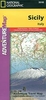

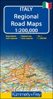
Sicily - Palermo - Catania K+F Regional Map
Sicily at 1:200, 000 from Kümmerly and Frey with cartography from the Italian publishers de Agostini. Each title in this series has a separate index booklet attached to the map cover providing enlargements with access to main cities plus several very clear street plans of other towns and smaller but important tourist destinations.The colouring of the road network clearly distinguishes between motorways, main or secondary routes and smaller local roads. Driving information includes full or partial motorway interchanges and services, toll roads, entry restrictions and possible seasonal closures, steep gradients, etc. Scenic roads are highlighted. Driving distances are marked on main and secondary roads. Railway lines are shown with stations and ferry route indicates approximate
crossing time. Locations worth visiting are prominently highlighted and symbols mark various other places of interest including mountain shelters, Blue Flag beaches, etc. Topography is very well presented by relief shading with plenty of names of mountain ranges, peaks with heights, etc. The maps also indicate main long-distance hiking trails such as the GTA (Grande Traversata delle Apli) or the GEA (Grande Escursione Appenninnica). Latitude and longitude lines are drawn at 10’ intervals. Map legend includes English.The index is in a separate booklet attached to the map cover. The booklet also includes enlargements of the environs of main cities plus city centre street plans of other towns. Also provided is a small overview map of Italy for route planning plus main driving
regulations.To see other titles in this series please click on the series link.

Product Description
Reviews/Comments
Add New
Vouchers
No voucher codes found.
Do you know a voucher code for this product or supplier? Add it to Insights for others to use.
Do you know a voucher code for this product or supplier? Add it to Insights for others to use.
 Denmark