
 United Kingdom
 France
 Germany
 Netherlands
 Sweden
 USA
USA
 Italy
Italy
 Spain
Spain
More From Contributor


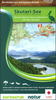


Skadar Lake National Park
Skadar Lake National Park and its environs on a detailed topographic map at 1:55, 000 from Huber Verlag with English language descriptions of hiking and biking trails accompanied by route profiles, and other information about the area. The map covers the National Park with the area between the lake and the Adriatic. Contours at 10m intervals are enhanced by relief shading, graphics to show swamps and colouring indicating woodlands and vineyards. An overprint highlights waymarked hiking and cycling routes and symbols indicate locations with tourist accommodation, cafes and restaurants, bird-watching towers, beaches, etc. Road network shows petrol stations and railway lines are presented with stations. The map has both 1-km UTM grid and latitude/longitude lines at intervals of 5
Product Description
Reviews/Comments
Add New
Intelligent Comparison
Archived Product
Sareks National Park Stanfords
£14.95
Archived Product
Sareks National Park Stanfords
£14.95
Archived Product
Crater Lake National Park OR Stanfords
£9.99
Archived Product

Skaftafell National Park Stanfords
£16.95
Archived Product

Kakadu National Park Stanfords
£17.99
Archived Product
Tarangire National Park Stanfords
£10.95
Archived Product
Lakefield National Park Stanfords
£8.95
Archived Product

Saguaro National Park AZ Stanfords
£9.99
Vouchers
No voucher codes found.
Do you know a voucher code for this product or supplier? Add it to Insights for others to use.
Do you know a voucher code for this product or supplier? Add it to Insights for others to use.
 Denmark