More From Contributor

£9.95
Aloniossos at 1:25, 000 on a contoured, GPS compatible hiking map published by Terrain Cartography group & printed on light, waterproof & tear-resistant Polyart plastic paper, with extensive tourist information. Skiathos at 1:15, 000 on a contoured, GPS compatible hiking map published by Terrain Cartography group & printed on light, waterproof & tear-resistant Polyart plastic paper, with extensive tourist information. Topography is very well presented by contours, enhanced by spot heights, subtle relief shading & additional altitude colouring. Contour interval, unless indicated below to the contrary, is 20m. National parks & other protected areas are marked. All place names are shown in both Greek & Latin alphabet. The maps have a UTM grid, plus latitude & longitude margin ticks. Hiking trails are graded between main routes & narrow trails. A wide range of symbols indicate various places of interest & recreational facilities, with main sights clearly highlighted. Most titles distinguish between sandy & pebble beaches; some also indicate beaches with natural shade and/or the type of sea bed. Road network is very clearly graded according to width & the type of surface, distinguishing between good & rough dirt roads. Distances are marked on most small local roads, as well as locations of petrol stations and/or tyre repair workshops. Scenic routes are highlighted. Each map also shows which ports are served by ferry services. Many titles include a street plan of the island ...
Archived Product
£5.99
Skiathos in the Sporades on light, a waterproof & tear-resistant, contoured & GPS compatible map at 1:25, 000 from Anavasi for exploring the island on foot or by car. Landscape is vividly shown by contours at 20m with altitude colouring, hill shading & spot heights. The map indicates dirt roads in poor condition, with distances marked on many local routes, plus locations of petrol stations. Also marked are stops of the local bus service. Country paths distinguish between wide & well defined or narrow and/or poorly defined routes. Symbols show hotels & campsites, tavernas, places of interest including beaches, archaeological sites, etc. All place names are in both Greek & Latin alphabets. The map has a 1km UTM grid plus latitude/longitude margin ticks & crosshairs at 1’. On the reverse are notes about the islands, including recommendations for four hiking routes. Map legend & the text include English. To see which other Greek islands are covered by maps from Anavasi, please click on the series link. ...
Archived Product
£9.99
Skiathos at 1:15, 000 on a contoured, GPS compatible hiking map published by Terrain Cartography group & printed on light, waterproof & tear-resistant Polyart plastic paper, with extensive tourist information. Topography is very well presented by contours, enhanced by spot heights, subtle relief shading & additional altitude colouring. Contour interval, unless indicated below to the contrary, is 20m. National parks & other protected areas are marked. All place names are shown in both Greek & Latin alphabet. The maps have a UTM grid, plus latitude & longitude margin ticks. Hiking trails are graded between main routes & narrow trails. A wide range of symbols indicate various places of interest & recreational facilities, with main sights clearly highlighted. Most titles distinguish between sandy & pebble beaches; some also indicate beaches with natural shade and/or the type of sea bed. Road network is very clearly graded according to width & the type of surface, distinguishing between good & rough dirt roads. Distances are marked on most small local roads, as well as locations of petrol stations and/or tyre repair workshops. Scenic routes are highlighted. Each map also shows which ports are served by ferry services. Many titles include a street plan of the island’s main town, with colouring clearly showing various tourist facilities. The reverse side of each title is covered by general information about the isl&, illustrated with colour photos. Many titles also include brief descriptions of recommended hiking trails.* Map legend & all the text include English.** In this title:* coverage

Includes::
the nearby island of Tsougria. On the reverse is general information about the island illustrated with colour photos.

...
Archived Product
£4.99
Hotspots Skiathos highlights the best of what this fashionable Greek island has to offer. The book

Features:


...
Archived Product
£23.99
Map No. 10149, Skibotndalen, in the new topographic survey of Norway at 1:50, 000 covering the country on 195 double-sided sheets & first published by Nordeca in 2011
- 2012; fully GPS compatible, indicating waymarked footpaths, campsites, tourist huts, illuminated ski runs, etc. The maps, now published by Nordeca, the successors to Statens Kartverk & its subsequent owners the Ugland Group, are printed on light, waterproof & tear-resistant synthetic paper. Each map covers an area of 62x 45 kilometres (39 x 28 miles approx.), with a 2-km overlap between the sheets. The maps have contours at 20m intervals (10m glacier contours), plus colouring & graphics to show cultivated areas, bogs, forests, etc. In addition to all the information expected of topographic mapping at this scale the maps distinguish between waymarked & unmarked footpaths & show campsites, tourist huts (serviced/self service/no supplies), country hotels & restaurants, & illuminated ski trails. The series uses EUREF89 (WGS84) datum & the maps have a 1-km UTM grid. Map legend is in Norwegian & English. Each title comes in a sturdy protective card envelope.
...
Archived Product
£23.99
Skien East area in Norway in a series of GPS compatible recreational maps at 1:25, 000 with cartography based on the country’s topographic survey & additional tourist information. The base map is an enlargement of the standard 1:50, 000 topographic survey series. Contours lines are drawn at 20m intervals. The overprint varies from title to title, but

Includes::
local footpaths, in some cases distinguishing between easy & more difficult trails, as well as mountain huts & campsites. Many titles also indicate cycle, ski or canoeing routes, other accommodation possibilities, sport & recreational facilities, including alpine skiing slopes, places of interest, etc. The maps have a UTM grid & margin ticks giving latitude & longitude. Map legend

Includes::
English. Several titles have on the reverse additional tourist information, although in most cases in Norwegian only. To see the list of Turkart maps at 1:25, 000 & links to Turkart series at 50K, 100K & Hiking Sets please click on the series link above.


...
Archived Product
£23.99
Map No. 10019, Skien, in the new topographic survey of Norway at 1:50, 000 covering the country on 195 double-sided sheets & first published by Nordeca in 2011
- 2012; fully GPS compatible, indicating waymarked footpaths, campsites, tourist huts, illuminated ski runs, etc. The maps, now published by Nordeca, the successors to Statens Kartverk & its subsequent owners the Ugland Group, are printed on light, waterproof & tear-resistant synthetic paper. Each map covers an area of 62x 45 kilometres (39 x 28 miles approx.), with a 2-km overlap between the sheets. The maps have contours at 20m intervals (10m glacier contours), plus colouring & graphics to show cultivated areas, bogs, forests, etc. In addition to all the information expected of topographic mapping at this scale the maps distinguish between waymarked & unmarked footpaths & show campsites, tourist huts (serviced/self service/no supplies), country hotels & restaurants, & illuminated ski trails. The series uses EUREF89 (WGS84) datum & the maps have a 1-km UTM grid. Map legend is in Norwegian & English. Each title comes in a sturdy protective card envelope.
...
Archived Product
£9.99
Skiing is an extremely popular sport that more & more people are taking up. However, the experience you have on your first skiing holiday can make or break your relationship with this sport. Aimed at beginners, this book will enable you to avoid all the pitfalls of skiing, giving you confidence on the slopes so you can enjoy the beautiful surroundings. Every aspect of this sport
- on & off the piste
- is covered: choosing whether you should ski or snowboard; deciding whether you need lessons & how many; information on every piece of equipment from head to toe, how to use it all & how to keep warm; the benefits of hiring or buying equipment; what exercises you should do before you go & how to ease the stiffness at the end of a long day`s skiing; information on snow conditions, terrain & weather & how to assess the condition on the piste; understanding altitude; how to ski & snowboard; the etiquette of skiing; where to go on holiday; how to plan your day`s skiing; what to eat to keep energised throughout the day; safety on the slopes & keeping injury free. Packed full of invaluable & up-to-date advice & written by a ski instructor, this book is both practical & inspiring & the perfect thing to read before you go & when you are there.

...
Archived Product
£6.99
Before the packed stadiums. Before he became a huge star. Jamie Johnson had to learn from the best. Jamie is the top player at his school but there`s something missing from his game. He needs that bit of extra flair. He wants that touch of magic. Can the once-in-a-lifetime chance to train on the beaches of Brazil give Jamie the skills he needs to become a legend? ...
Archived Product
£6.99
We must find him or the train can`t start! All aboard as Skimbleshanks, the Railway Cat, stars in the third picture-book pairing from Arthur Robins & T. S. Eliot`s Old Possum`s cats, set on the Night Mail train where Skimble won`t let anything go wrong. To sit alongside other classics such as The Gruffalo, The Tiger Who Came to Tea, & Spot. ...
Archived Product

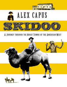
Skidoo: A Journey Through The Ghost Towns Of The American West

In the company of bank robbers and grave diggers, desperados and cunning Indians, brewers and failing inventors, Alex Capus visits the Wild West`s ghost towns, where he descends into a disused silver mine and looks for traces left by the robbers who held-up stage coaches in Death Valley. Capus discovers stories that are a match for any Western: In Bodie the gravediggers used dynamite rather than shovels to blow holes in the ground; in the town of Skidoo, Hootch Simpson, a brawling bartender, was first hung by the mob, then by the law, before being beheaded during his autopsy; in Flagstaff, Capus finds that the legendary Route 66 was, for a time at least, a trail for Edward Fitzgerald Beale`s `Camel Corps`.
RIP - This product is no longer available on our network. It was last seen on 25.09.2019

This page now acts as a permanent archive for this product. Add more information using the comments box below to ensure it can still be found by future generations.

Use our search facility to see if it is available from an alternative contributor.
  • Availability: Out Of Stock
  • Supplier: Stanfords
  • SKU: 9781907973956
Availability: In Stock
£12.99

Product Description

In the company of bank robbers & grave diggers, desperados & cunning Indians, brewers & failing inventors, Alex Capus visits the Wild West`s ghost towns, where he descends into a disused silver mine & looks for traces left by the robbers who held-up stage coaches in Death Valley. Capus discovers stories that are a match for any Western: In Bodie the gravediggers used dynamite rather than shovels to blow holes in the ground; in the town of Skidoo, Hootch Simpson, a brawling bartender, was first hung by the mob, then by the law, before being beheaded during his autopsy; in Flagstaff, Capus finds that the legendary Route 66 was, for a time at least, a trail for Edward Fitzgerald Beale`s ` Camel Corps`.

Reviews/Comments

Add New

Intelligent Comparison

Oooops!
We couldn't find anything!
Perhaps this product's unique.... Or perhaps we are still looking for comparisons!
Click to bump this page and we'll hurry up.

Price History

Vouchers

No voucher codes found.
Do you know a voucher code for this product or supplier? Add it to Insights for others to use.

Facebook

Jargon Buster

Silver - A colour based on the colour of the metal
Silver - A chemical element, metalic. Has the highest elctrical conductance of any element. Also known for its exceptional anitmicrobal properties

Supplier Information

Stanfords
Stanfords was established in 1853 and opened their iconic Covent Garden flagship store in 1901. They have become the top retailer of maps, travel books and accessories in the UK and arguably offer the largest selection of maps and travel books worldwide. Famous names such as Captain Robert Falcon Scott, Ranulph Fiennes and Michael Palin have purchased from Stanfords. They now have a shop in Bristol and both stores together with other venues operate a calendar of events including talks, book signings and exhibitions. As a specialist map retailer, the map selection is comprehensive and includes road maps, street maps and walking maps from worldwide destinations, as well as a selection of world atlases and wall maps. Books include travel guides and travel literature. Stanfords also stock globes, from miniatures made of blue marble to magnificent floor-standing globes. The website features a selection of interesting articles on travel topics.
Page Updated: 2023-11-12 20:15:36

Community Generated Product Tags

Oh No! The productWIKI community hasn't generated any tags for this product yet!
Menu