
 United Kingdom
 France
 Germany
 Netherlands
 Sweden
 USA
USA
 Italy
Italy
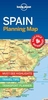
 Spain
Spain
More From Contributor


Spain North - Santiago Route
Indexed, waterproof and tear-resistant road map of northern Spain highlighting pilgrim routes to Santiago de Compostela. The map, published by Reise Know-How as part of their highly acclaimed World Mapping Project, combines topographic and tourist information and is double-sided to provide the best balance between a good scale and a convenient size sheet.Road and rail networks are easy to see on a clear base which presents topography by altitude colouring with contours, spot heights, mountain passes and names of mountain ranges. Road network includes local roads and tracks and gives driving distances on main and secondary roads. Internal administrative boundaries are shown with names of the provinces. The main route of the Way of St James from Pamplona, across Logro
Product Description
Reviews/Comments
Add New
Intelligent Comparison
Archived Product

Spain North - Santiago Route Reise Know-How Stanfords
£11.50
Vouchers
No voucher codes found.
Do you know a voucher code for this product or supplier? Add it to Insights for others to use.
Do you know a voucher code for this product or supplier? Add it to Insights for others to use.
 Denmark