More From Contributor
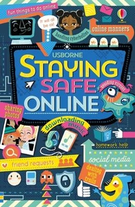
£14.99
` There are things even love can`t do... If the burden is too much & stays too long, even love bends, cracks, comes close to breaking & sometimes does break. But even when it`s in a thousand pieces around your feet, that doesn`t mean it`s no longer love... ` Yejide is hoping for a miracle, for a child. It is all her husband wants, all her mother-in-law wants, & she has tried everything
- arduous pilgrimages, medical consultations, dances with prophets, appeals to God. But when her in-laws insist upon a new wife, it is too much for Yejide to bear. It will lead to jealousy, betrayal & despair. Unravelling against the social & political turbulence of 80s Nigeria, Stay With Me sings with the voices, colours, joys & fears of its surroundings. Ayobami Adebayo weaves a devastating story of the fragility of married love, the undoing of family, the wretchedness of grief, & the all-consuming bonds of motherhood. It is a tale about our desperate attempts to save ourselves & those we love from heartbreak.
...
Archived Product
£8.99
SHORTLISTED FOR THE 2017 BAILEYS WOMEN`S PRIZE FOR FICTIONSHORTLISTED FOR THE 2018 WELLCOME BOOK PRIZELONGLISTED FOR THE 2018 INTERNATIONAL DYLAN THOMAS PRIZEYejide is hoping for a miracle, for a child. It is all her husband wants, all her mother-in-law wants, & she has tried everything. But when her relatives insist upon a new wife, it is too much for Yejide to bear. Unravelling against the social & political turbulence of 1980s Nigeria, Stay With Me is a story of the fragility of married love, the undoing of family, the power of grief, & the all-consuming bonds of motherhood. It is a tale about the desperate attempts we make to save ourselves, & those we love, from heartbreak. ...
Archived Product
£7.99
`...into the annals of modern polar history strays another character
- part legend, part myth, part fibreglass. She is STAY.`
...
Archived Product
£14.99
Staying Alive in Avalanche Territory is a comprehensive skills guide aimed at those who engage in off-piste winter mountain activities. Highly practical in nature, the author explores every facet of avalanches; individual chapters are dedicated to avalanche basics, how they work, terrain management, weather, snowpack, stability, hazard evaluation, route-finding & safe travel rituals, rescue & the ...
Archived Product
£7.99
Tony Metcalfe, Yorkshireman & retired expat, is going through a three-quarter life crisis. Viva Espagne
- his bar at the heart
...
Archived Product
£12.99
Map No. 1112, Stäfa, in the topographic survey of Switzerland at 1:25, 000 from Bundesamt für Landestopographie (swisstopo), covering the whole country on 247 small format sheets, with special larger maps published for popular regions including some titles now available in hiking versions. Highly regarded for their superb use of graphic relief & hill shading, the maps give an almost 3-D picture of Switzerland`s mountainous terrain. Contours are at 10 m intervals, with 20m intervals in the mountainous areas. All the maps have a 1-km grid for Swiss national coordinates (datum CH 1903). * Small format sheets (Nos. 1011
- 1374)* Map legend in the language of the area covered by the map. Additional margin ticks show latitude & longitude in steps of 2`. The area covered by each map is 17 x 12 km (11 x 7 miles approx). * Special larger sheets (Nos. from 2501 onwards) – STANDARD editions:* No map legend is included but a separate leaflet can be provided instead. The area covered by each map is 25 x 17 km (15 x 11 miles approx).* Special larger sheets (Nos. from 2501 onwards) – HIKING editions:* An overprint highlights hiking, mountain & alpine paths, including regional & national long-distance trails. The maps also show bus routes with bus stops, plus inns in remote locations. The area covered by each map is 25 x 17 km (15 x 11 miles approx).
...
Archived Product
£16.99
Topographic survey of Sweden at 1:50, 000, the Terrängkartan, from the Lantmäteriet, covering most of the country in 244 double-sided maps. Please note: the mountainous regions of central & northern Sweden are not covered by this series but presented in a separate “ Fjällkartan
- Mountain Map” series also listed on our website. Each 1:50, 000 topographic survey map covers an area of 37.5 x 40km. The maps have contours at 5 metre intervals, plus relief shading & graphics for rocky outcrops & boulders. Further graphics and/or colouring show different types of land use or vegetation (forests, arable l&, orchards, marshes, peat bogs, etc). An unusual feature of this survey is the colouring indicating buildings below or above two storeys high & “leisure/holiday homes”. The maps indicate privately maintained roads & include all other information expected of topographic survey at this scale. The maps have a 1-km UTM grid, plus latitude & longitude lines 5’ intervals. Map legend

Includes::
English. For coverage of the country’s most visited hiking areas in central & northern Sweden please see Lantmäteriet’s Mountain Map series, listed separately on our website.


...
Archived Product
£23.99
Map No. 10085, Støren, in the new topographic survey of Norway at 1:50, 000 covering the country on 195 double-sided sheets & first published by Nordeca in 2011
- 2012; fully GPS compatible, indicating waymarked footpaths, campsites, tourist huts, illuminated ski runs, etc. The maps, now published by Nordeca, the successors to Statens Kartverk & its subsequent owners the Ugland Group, are printed on light, waterproof & tear-resistant synthetic paper. Each map covers an area of 62x 45 kilometres (39 x 28 miles approx.), with a 2-km overlap between the sheets. The maps have contours at 20m intervals (10m glacier contours), plus colouring & graphics to show cultivated areas, bogs, forests, etc. In addition to all the information expected of topographic mapping at this scale the maps distinguish between waymarked & unmarked footpaths & show campsites, tourist huts (serviced/self service/no supplies), country hotels & restaurants, & illuminated ski trails. The series uses EUREF89 (WGS84) datum & the maps have a 1-km UTM grid. Map legend is in Norwegian & English. Each title comes in a sturdy protective card envelope.
...
Archived Product
£50.00
The International Convention on Standards of Training, Certification & Watchkeeping for Seafarers, 1978 (STCW Convention), aims to promote safety of life & property at sea & protection of the marine environment by establishing international standards of training, certification & watchkeeping for seafarers. This publication contains the Final Act of the 2010 Conference of Parties to the 1978 STCW Convention, resolutions adopted by that Conference, & a complete, consolidated text of the STCW Convention, including its original articles, revised annex & supporting STCW Code. This edition incorporates the 2014 amendments (MSC.373 (93) & MSC.374 (93)), the 2015 amendments (MSC.396 (95) & MSC.397 (95)) & the 2016 Amendments (MSC.416 (97) & MSC.417 (97)). ...
Archived Product
£12.99
Map No. 1182, Ste-Croix, in the topographic survey of Switzerland at 1:25, 000 from Bundesamt für Landestopographie (swisstopo), covering the whole country on 247 small format sheets, with special larger maps published for popular regions including some titles now available in hiking versions. Highly regarded for their superb use of graphic relief & hill shading, the maps give an almost 3-D picture of Switzerland`s mountainous terrain. Contours are at 10 m intervals, with 20m intervals in the mountainous areas. All the maps have a 1-km grid for Swiss national coordinates (datum CH 1903). * Small format sheets (Nos. 1011
- 1374)* Map legend in the language of the area covered by the map. Additional margin ticks show latitude & longitude in steps of 2`. The area covered by each map is 17 x 12 km (11 x 7 miles approx). * Special larger sheets (Nos. from 2501 onwards) – STANDARD editions:* No map legend is included but a separate leaflet can be provided instead. The area covered by each map is 25 x 17 km (15 x 11 miles approx).* Special larger sheets (Nos. from 2501 onwards) – HIKING editions:* An overprint highlights hiking, mountain & alpine paths, including regional & national long-distance trails. The maps also show bus routes with bus stops, plus inns in remote locations. The area covered by each map is 25 x 17 km (15 x 11 miles approx).
...
Archived Product

Staying Safe Online

As the cyber world continues to grow it is becoming increasingly important for children to stay safe online and learn what sort of things to avoid or report. This book provides clear and helpful guidelines to internet safety, covering a wide range of topics that children and adults should be aware of. Illustrations: Full colour throughout
RIP - This product is no longer available on our network. It was last seen on 25.09.2019

This page now acts as a permanent archive for this product. Add more information using the comments box below to ensure it can still be found by future generations.

Use our search facility to see if it is available from an alternative contributor.
  • Availability: Out Of Stock
  • Supplier: Stanfords
  • SKU: 9781409597810
Availability: In Stock
£6.99

Product Description

As the cyber world continues to grow it is becoming increasingly important for children to stay safe online & learn what sort of things to avoid or report. This book provides clear & helpful guidelines to internet safety, covering a wide range of topics that children & adults should be aware of. Illustrations: Full colour throughout

Reviews/Comments

Add New

Intelligent Comparison

Oooops!
We couldn't find anything!
Perhaps this product's unique.... Or perhaps we are still looking for comparisons!
Click to bump this page and we'll hurry up.

Price History

Vouchers

No voucher codes found.
Do you know a voucher code for this product or supplier? Add it to Insights for others to use.

Facebook

Jargon Buster

World - A physical grouping, commonly used to describe earth and everything associated with ti
Colour - The categorised spectrum of light visable to humans
Safety - prevents damage being caused.
Wide - Something with a large width.
illustrations - Pictures typically in books and newspapers.
Children - A young life form within the early stages of physical development,

Supplier Information

Stanfords
Stanfords was established in 1853 and opened their iconic Covent Garden flagship store in 1901. They have become the top retailer of maps, travel books and accessories in the UK and arguably offer the largest selection of maps and travel books worldwide. Famous names such as Captain Robert Falcon Scott, Ranulph Fiennes and Michael Palin have purchased from Stanfords. They now have a shop in Bristol and both stores together with other venues operate a calendar of events including talks, book signings and exhibitions. As a specialist map retailer, the map selection is comprehensive and includes road maps, street maps and walking maps from worldwide destinations, as well as a selection of world atlases and wall maps. Books include travel guides and travel literature. Stanfords also stock globes, from miniatures made of blue marble to magnificent floor-standing globes. The website features a selection of interesting articles on travel topics.
Page Updated: 2023-11-12 20:15:36

Community Generated Product Tags

Oh No! The productWIKI community hasn't generated any tags for this product yet!
Menu