More From Contributor

£6.99
From the author of bestselling debut NED`S CIRCUS OF MARVELS... Roll up, roll up, & prepare to be AMAZED AGAIN by Ned & the marvellous, magical, monstrous flying circus! Ned & his family are trying to be ordinary except for the small fact that they AREN`T. AT ALL. Because on the run up to Christmas everything is ruined when all the world`s gold goes missing, along with its leading scientists. Which doesn`t really have anything to do with Ned... until it does. When an oily thief & his pet monster turn up at Ned`s door, Ned finds himself on the run again... & racing to find out what this new villain wants. Meanwhile, in the shadows, a machine with a mind of its own vies for power, & mysterious men in grey suits are watching the Circus of Marvels` every move. Together with his best friend Lucy, his clockwork mouse & his shadow, Ned must use his growing magical powers to try to uncover a secret that could end them all... ...
Archived Product
£9.99
Into the insular town of 1930s Ferrara, a new doctor arrives. Fadigati is hopeful & modern, & more than anything wants to fit into his new home. But his fresh, appealing appearance soon crumbles when the townsfolk discover his homosexuality, & the young man he pays to be his lover humiliates him publicly. As anti-Semitism spreads across Italy, the Jewish narrator of the tale begins to feel pity for the ostracized doctor, as the fickle nature of a community changing under political forces becomes clear. ” The Gold-Rimmed Spectacles” is a gripping & tragic study of how lives can be destroyed by those we consider our neighbours. ...
Archived Product
£16.99
Charles V, Emperor of Europe & the New World, is the central figure The Golden age, the second volume of Hugh Thomas’s superb ...
Archived Product
£14.99
The Golden Age of Discovery is a photographic tribute to the adventures, dangers, hardships, & accomplishments of modern expeditions. In this golden age of exploration & discovery, our knowledge of this planet is being expanded as never before in human history. Discoveries like plate tectonics, desertification, the hole in the ozone layer, & the greenhouse effect have transformed our understanding of the earth & its climate. & from the mountain peaks to ocean floors, untrodden places are being explored for the very first time. It also

Includes::
profiles of noted explorers as well as features on the main fields of sporting exploration, & John Hemming's text is dramatically enhanced with 200 color photos & maps from around the world. John Hemming was Director of the Royal Geographic Society for more than two decades.

...
Archived Product
£25.00
The Golden Age of European Railways presents the history of Europe’s main railway routes during the late nineteenth & early twentieth century with interesting & informative text from a team of award-winning writers & acknowledged railway experts, lavishly illustrated by contemporary posters, postcards, paintings, maps, photos, etc, as well as present-day photos of restored rolling stock. Chapters are arranged by country or region, from the Settle to Carlisle route & the Jungfraujoch tunnel to that ultimate railway line, the Trans-Siberian, & cover specially selected lines in Great Britain, Irel&, Belgium, France, Italy, Croatia, Greece, Spain, Portugal, Germany, Austria, Switzerl&, Pol&, Russia, Norway, Sweden & Finl&. The appendix contains further chapters on classic European locomotives, carriage design & railway museums. The presentation & the range of illustrations in this book are simply exceptional, from paintings like Claude Monet’s view of Gare Saint-Lazare & those wonderful advertising posters from the interwar period to numerous postcards of old, some long-gone stations, etc. The selection of maps from various publishers or national surveys is excellent. The book will appeal not only to railway enthusiasts but also to anyone interested in graphic design from that period or simply in the history of Europe. ...
Archived Product
£12.99
Few sights can reawaken memories of happy holidays of yesteryear as vividly as the superb railway posters that were so much ...
Archived Product
£19.95
Between the introduction of the marine turbine & the post-war challenges of air travel & revolutionary cargo-handling procedures, the period covered by this book witnesses a culmination in the development of the merchant ship. The great transatlantic liners, the fast packets & simple tramp steamers, for example, achieved a form of perfection that many regard as classic. These & many other types are described & analyzed in detail in this book. ...
Archived Product
£9.99
First published in 1949, ” The Golden Apples” is an acutely observed, richly atmospheric portrayal of small town life in Morgana, Mississippi. There`s Snowdie, who has to bring up her twin boys alone after her husb&, King Maclain, disappears one day, discarding his hat on the banks of the Big Black. There`s Loch Morrison, convalescing with malaria, who watches from his bedroom window as wayward Virgie Rainey meets a sailor in the vacant house opposite. Meanwhile, Miss Eckhart the piano teacher, grieving the loss of her most promising pupil, tries her hand at arson. Eudora Welty has a fine ear for dialogue & describes each of the characters in incisive, haunting prose. `...in the South, ` she says, `everybody stays busy talking all the time
- they`re not sorry for you to overhear their tales`. Welty deftly picks up their stories to create an unflinching potrait of everyday life in the American South & offers a deeply moving look at human nature.
...
Archived Product
£25.00
The Golden Atlas is a spectacular visual history of exploration & cartography, a treasure chest of adventures from the chronicles of global discovery, illustrated with a selection of the most beautiful maps ever created. The book reveals how the world came to be known, featuring a magnificent gallery of exceptionally rare h&-coloured antique maps, paintings & engravings, many of which can only be found in the author`s collection. Arranged chronologically, the reader is taken on a breathtaking expedition through Ancient Babylonian geography & Marco Polo`s journey to the Mongol Khan on to buccaneers ransacking the Caribbean & the voyages of seafarers such as Captain Cook & fearless African pathfinders. Their stories are told in an engaging & compelling style, bringing vividly to life a motley collection of heroic explorers, treasure-hunters & death-dealing villains
- all of them accompanied by eye-grabbing illustrations from rare maps, charts & manuscripts. The Golden Atlas takes you back to a world of darkness & peril, placing you on storm-lashed ships, frozen wastelands & the shores of hostile territories to see how the lines were drawn to form the shape of the modern world. The author`s previous book, The Phantom Atlas, was a critically acclaimed international bestseller, described by Jonathan Ross as `a spectacular, enjoyable & eye-opening read` & this new book is sure to follow suit.
...
Archived Product

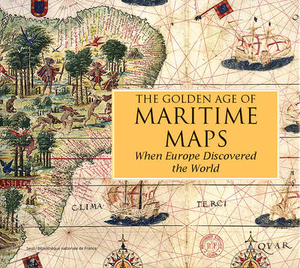
The Golden Age Of Maritime Maps: When Europe Discovered The World

`Portolan charts`, so called from the Italian adjective portolano, meaning `related to ports or harbours`, were born during the 12th century in the maritime community. These charts, drawn on parchment and crisscrossed with lines referring to the compass directions, indicated the succession of ports and anchorages along the shores, and were used by European sailors exploring the world up until the 18th century. Not only used as navigational instruments on boats, they were also produced for wealthy sponsors in the form of illuminated images of the world, to illustrate the economic and political interests of the major European sea powers. This book takes stock of the state of knowledge on these maps, bringing together contributions from a dozen European specialists, who trace the
history and diversity of styles and places of production of these charts. This type of mapping is approached from three angles. The first part, `The Mediterranean`, refers to the manufacture and use of the first charts, centered on the Mediterranean, and the persistence of this tradition in the Mediterranean basin until the 18th century.The second part, `The Open Sea`, shows how these regional charts have evolved from a technical and iconographical point of view at the time of the great European voyages, in order to include the oceans and new worlds. The third part, `The Indian Ocean`, shows how these charts, in a maritime area where ancient civilizations coexisted, were dependent on other cartographic traditions (ancient, Arab, Asian) before joining the information reported
by Portuguese sailors and European trading companies in the modern era.
RIP - This product is no longer available on our network. It was last seen on 25.09.2019

This page now acts as a permanent archive for this product. Add more information using the comments box below to ensure it can still be found by future generations.

Use our search facility to see if it is available from an alternative contributor.
  • External links may include paid for promotion
  • Availability: Out Of Stock
  • Supplier: Stanfords
  • SKU: 9781770852389
Availability: In Stock
£35.00

Product Description

` Portolan charts`, so called from the Italian adjective portolano, meaning `related to ports or harbours`, were born during the 12th century in the maritime community. These charts, drawn on parchment & crisscrossed with lines referring to the compass directions, indicated the succession of ports & anchorages along the shores, & were used by European sailors exploring the world up until the 18th century. Not only used as navigational instruments on boats, they were also produced for wealthy sponsors in the form of illuminated images of the world, to illustrate the economic & political interests of the major European sea powers. This book takes stock of the state of knowledge on these maps, bringing together contributions from a dozen European specialists, who trace the history & diversity of styles & places of production of these charts. This type of mapping is approached from three angles. The first part, ` The Mediterranean`, refers to the manufacture & use of the first charts, centered on the Mediterranean, & the persistence of this tradition in the Mediterranean basin until the 18th century. The second part, ` The Open Sea`, shows how these regional charts have evolved from a technical & iconographical point of view at the time of the great European voyages, in order to include the oceans & new worlds. The third part, ` The Indian Ocean`, shows how these charts, in a maritime area where ancient civilizations coexisted, were dependent on other cartographic traditions (ancient, Arab, Asian) before joining the information reported by Portuguese sailors & European trading companies in the modern era.

Reviews/Comments

Add New

Intelligent Comparison

Oooops!
We couldn't find anything!
Perhaps this product's unique.... Or perhaps we are still looking for comparisons!
Click to bump this page and we'll hurry up.

Price History

Vouchers

No voucher codes found.
Do you know a voucher code for this product or supplier? Add it to Insights for others to use.

Facebook

Jargon Buster

Italian - A word used ot descibe something from Italy
History - Anything that happens in the past. An acedemic subject.
World - A physical grouping, commonly used to describe earth and everything associated with ti
technical - Something that relates to a good level of skill and methods.
Regional - An adjective to describe a set geographic area.

Supplier Information

Stanfords
Stanfords was established in 1853 and opened their iconic Covent Garden flagship store in 1901. They have become the top retailer of maps, travel books and accessories in the UK and arguably offer the largest selection of maps and travel books worldwide. Famous names such as Captain Robert Falcon Scott, Ranulph Fiennes and Michael Palin have purchased from Stanfords. They now have a shop in Bristol and both stores together with other venues operate a calendar of events including talks, book signings and exhibitions. As a specialist map retailer, the map selection is comprehensive and includes road maps, street maps and walking maps from worldwide destinations, as well as a selection of world atlases and wall maps. Books include travel guides and travel literature. Stanfords also stock globes, from miniatures made of blue marble to magnificent floor-standing globes. The website features a selection of interesting articles on travel topics.
Page Updated: 2023-11-12 20:15:36

Community Generated Product Tags

Oh No! The productWIKI community hasn't generated any tags for this product yet!
Menu