
 United Kingdom
 France
 Germany
 Netherlands
 Sweden
 USA
USA
 Italy
Italy
 Spain
Spain
More From Contributor


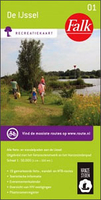
The IJssel
The Ijssel is the first of a series two recreational maps for the Flevoland region.These maps were created to celebrate the 25th anniversary of the province of Flevoland. They are double-sided indexed maps at 1:50, 000 scale, featuring a detailed topography with prominent highlighting of the cycle routes and packed with practical tourist information. They also include a calendar of annual events and feature all the local hiking trails. Falk maps give cycling distances between the junctions and indicate which roads, both within the numbered network and outside it, have separate cycling paths. Routes which are part of the LF network of long-distance cycle routes are clearly marked. A wide range of symbols shows various accommodation options, bars and restaurants, and various places of
interest. Landscape information is provided by colouring for woodlands, dunes, etc. Map legend includes English.To see the list of other titles in this series please click on the series link.
interest. Landscape information is provided by colouring for woodlands, dunes, etc. Map legend includes English.To see the list of other titles in this series please click on the series link.

Product Description
Reviews/Comments
Add New
Vouchers
No voucher codes found.
Do you know a voucher code for this product or supplier? Add it to Insights for others to use.
Do you know a voucher code for this product or supplier? Add it to Insights for others to use.
 Denmark