More From Contributor

£14.95
A guidebook to Scotland`s West Highland Way, a 95-mile walk from Milngavie near Glasgow to Fort William, passing Loch Lomond, crossing Rannoch Moor & finishing in the shadow of Britain`s highest mountain. The walk, which takes roughly one week to complete, is described in seven stages, with each stage ranging from 8 to 20 miles. The guide details the `classic` south-north direction but also provides a summary description for those wanting to walk the route in the opposite direction. The guidebook, which features step-by-step route descriptions, 1:100K mapping, handy practical information as well as notes on the region`s history, culture & geography, is accompanied by a separate, pocket-sized 1:25K OS map booklet, providing all the mapping you need to walk the route. Passing from the lowlands to the highlands, the West Highland Way, which is one of Scotland`s Great Trails, showcases the splendour of glens flanked by great mountains, majestic moorland & sprawling farml&. It is the perfect adventure for distance walkers keen to discover the wild beauty of western Scotl&. ...
Archived Product
£9.99
The part of Scotland which stretches from Lochaber to Durness contains some of the most spectacular scenery in the whole of the British Isles. Its great sea lochs & towering mountains have for hundreds of years attracted those inspired by rugged, romantic scenery, as well as those who want to explore the heartland of the Scottish clans or trace the steps of St Columba, who travelled through the Great Glen to convert the Picts in the sixth century. John Mac Pherson conveys the various moods of this remote & austere land in a series of remarkable photographs which convey the unique spirit of this extraordinary place. ...
Archived Product
£35.00
The most detailed description of why the countryside of England now looks the way it does, covering the geology, archaeology & history of each area & what effects each has had on the landscape we see today.
Includes:: What Manner of Place is This?
- Barry Cunliffe Rhythms of change: a region of contrasts
- Mike Allen & Julie Gardiner Peopling the Landscape
- Julie Gardiner & Mike Allen Villages & Markets
- James Bond The Architecture of Power
- James Bond Dynamics & Demography
- James Bond A Kaleidoscope of Regions
- James Bond Revenue from Rocks: Peter Ellis Looking Outwards
- Barry Cunliffe Landscape & Legend
- Jeremy Harte West Country Spas
- Sam Hunt Fossils & Ferns
- Jo Draper Romanticism & Recreation
- Trevor Rowley


...
Archived Product
£12.99
Double-sided map of the Western Front across northern France & Belgium during World War I, presenting the battlefields in a series of map panels annotated with present day monuments and/or front lines & directions of various offensives, plus extensive informative additional notes & numerous photos. On one side separate panels show the main battlefield areas with present day road network & locations of various cemeteries & monuments. The panels cover the Ypres Salient, the Somme battlefields, the Verdun area, the Paris
- Château Thierry
- Reims area, the battlefields between Arras & Lens with Vimy Ridge, & the area south of Armentières. An overview map of northern France & the Low Countries indicates coverage by these more detailed panels & shows major roads across the whole region. Each panel is accompanied by notes & colour photos of its main locations. The reverse side provides a general map of the whole area of the Western Front from the Channel to Nancy, indicating the front lines & the direction of offensives during different stages of the war, from the first German advance in 1914 to the Armistice Line. The map is surrounded by several panels of more detailed maps, extensive text on various aspects of the Great War, & contemporary black-&-white photos. Also provided here is a political map of Europe at the start of the conflict & a chronology table listing main events between the assassination of Archduke Franz Ferdinand in Sarajevo & the Armistice.PLEASE NOTE: this title provides an extremely comprehensive & informative overview of various areas & topics relating to the Western Front & World War I. For visiting specific theatres of the conflict, particularly the Somme battlefields & the Ypres Salient with their numerous cemeteries & monuments, we recommend purchasing more detailed maps of each area, such the Holt maps or maps from the two national survey organizations: the IGN & the Belgian Survey.

...
Archived Product
£14.99
The photographs included & analysed here were taken by the Royal Flying Corps to provide reconnaissance for the British Army on the Western Front & are drawn for the huge archive held by The Imperial War Museum. Few have had the courage to delve into the ` Box Collection`. Nicholas Watkis is one. The images have been chosen to reveal significant actions & have been carefully annotated to show the terrain & defences, pinpointing strongpoints, machine guns, mortars & gun batteries. The seven battles are Neuve Chapelle, Loos, La Boiselle, Flers, Vimy Ridge, Cambrai & Amiens. Not only does the real work of the RFC become clear
- shooting down enemy aircraft was entirely ancillary to photo recon
- the reader also, quite literally, sees for himself just what the Western Front looked like. He also understands how that appearance affected the plans of British High Comm&.

...
Archived Product
£9.99
This volume of pen-&-ink drawings of Scottish mountain scenery by A. Wainwright
- author of the legendary Pictorial Guides to the
...
Archived Product
£12.99
The Western coast of Turkey has captivated travellers for centuries. With its dramatic mountains & idyllic bays & promontories, scattered with ancient ruins, it is not only one of the most beautiful parts of the country, but is also of great historical interest. The Western Shores of Turkey is the distillation of a succession of journeys that John Freely made along this coast
- an odyssey spanning a quarter of a century. From Istanbul to Antakya (Antioch) on the Syrian border, he discovered both the charm of modern Turkey & the wonders of its past. The result is both an informative guide & a remarkable travelogue for all who follow in his footsteps.
...
Archived Product
£14.50
Crammed into Westminster & Pimlico are an abbey, a cathedral, a parliament, palaces, numerous government offices, up-market shops, men's clubs, beautiful parks, statues galore, theatres, the most famous clock in the world & one of the best schools in the country. 150 years ago the list would have included breweries & brothels, for here, in the capital of the world's richest nation, an underclass of starving, wretched people existed within shouting distance of those who governed them. This is an A-Z historical guide to the area. ...
Archived Product
£8.99
In the depths of the Cotswolds, near Tetbury in Gloucestershire, lies one of the most beautiful tree gardens in the world. Known as Westonbirt Arboretum. Here you can find around 15, 000 trees, each one lovingly labelled. They offer the perfect, picturesque setting for escaping from the pressures of everyday life. Now, for the first time, 100 of the most popular British trees form the basis of this beautiful pocket guide. Illustrated with artwork depicting the tree & leaf, this covetable little book will educate & entertain with wonderfully concise text by one of the world’s leading tree experts from the Arboretum. Pop this book in your pocket for a great day out spotting some of the most celebrated features of our landscape. ...
Archived Product
£16.95
This guidebook is all you need to discover The Westweg, a 285km walk along the length Germany`s Black Forest from Pforzheim to Basel. This classic long-distance trail takes around two weeks to walk, in stages of 15-28km. The route is well way-marked & suitable for experienced hikers & those new to long distance walking, though some sections are steep. The Westweg incorporates many of the region`s highlights, such the Schwarzwald National Park, the source of the Danube & Lake Titisee. At Titisee there is a choice to make: the western route taking in the Black Forest`s highest peak Feldberg & the vineyards of the Markgraflerl&, or the quieter eastern route via the Herzogenhorn peak & on to Basel, with all its cultural attractions & old-world charm. With well-maintained & waymarked trails, an efficient public transport system & conveniently placed huts & farmhouse inns, the Black Forest is one of Germany`s best-loved walking destinations. Soft-contoured, forest-clad hills, interspersed with pastures & picturesque villages combine on with far-ranging vistas right across the Alpine chain. Detailed descriptions & 1:100, 000 maps accompany each stage of the route & the book describes options for shortening stages using public transport. There is also information on when to go, where to stay & a German-English glossary
- all of which will earn this useful guide a place in your rucksack.
...
Archived Product

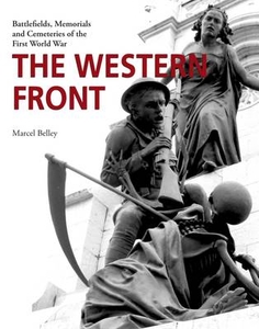
The Western Front: Battlefields, Memorials And Cemeteries Of The
First World War

The area of Belgium and northern France that was the Western Front is a place like no other. In a line running seven hundred kilometers from the English Channel to the Swiss border the horrors of industrialised war consumed men by the millions for over four years.When the War finally ended, entire societies were in shock and the ensuing outpouring of grief can be seen today in the countless cemeteries and memorials that dot the landscape. Much has been written of the British experience and the work of the Commonwealth War Graves Commission including the major architects of national memorials, but little material can be found regarding the American, French and German sites. In 2013 Marcel and a friend travelled the entire length of the Western Front. The images he captured tell an
amazing story and the chapters of the book are organised in such a way as to help the reader to understand the stupendous efforts of the nations involved to remember their fallen
RIP - This product is no longer available on our network. It was last seen on 25.09.2019

This page now acts as a permanent archive for this product. Add more information using the comments box below to ensure it can still be found by future generations.

Use our search facility to see if it is available from an alternative contributor.
  • Availability: Out Of Stock
  • Supplier: Stanfords
  • SKU: 9781910500675
Availability: In Stock
£28.00

Product Description

The area of Belgium & northern France that was the Western Front is a place like no other. In a line running seven hundred kilometers from the English Channel to the Swiss border the horrors of industrialised war consumed men by the millions for over four years. When the War finally ended, entire societies were in shock & the ensuing outpouring of grief can be seen today in the countless cemeteries & memorials that dot the landscape. Much has been written of the British experience & the work of the Commonwealth War Graves Commission including the major architects of national memorials, but little material can be found regarding the American, French & German sites. In 2013 Marcel & a friend travelled the entire length of the Western Front. The images he captured tell an amazing story & the chapters of the book are organised in such a way as to help the reader to understand the stupendous efforts of the nations involved to remember their fallen

Reviews/Comments

Add New

Intelligent Comparison

Oooops!
We couldn't find anything!
Perhaps this product's unique.... Or perhaps we are still looking for comparisons!
Click to bump this page and we'll hurry up.

Price History

Vouchers

No voucher codes found.
Do you know a voucher code for this product or supplier? Add it to Insights for others to use.

Facebook

Jargon Buster

France - A state situated in Western Europe with several overseas territories.
swiss - Short for Switzerland, one of the richest countries in the world
World - A physical grouping, commonly used to describe earth and everything associated with ti
running - A sport or hobbie of moving rapidly on foot. Can also refer to the running of equipment or run time refering to the length of time an applicance can run or the quiet running of an applicance.
Experience - To gain further knowledge by practising.

Supplier Information

Stanfords
Stanfords was established in 1853 and opened their iconic Covent Garden flagship store in 1901. They have become the top retailer of maps, travel books and accessories in the UK and arguably offer the largest selection of maps and travel books worldwide. Famous names such as Captain Robert Falcon Scott, Ranulph Fiennes and Michael Palin have purchased from Stanfords. They now have a shop in Bristol and both stores together with other venues operate a calendar of events including talks, book signings and exhibitions. As a specialist map retailer, the map selection is comprehensive and includes road maps, street maps and walking maps from worldwide destinations, as well as a selection of world atlases and wall maps. Books include travel guides and travel literature. Stanfords also stock globes, from miniatures made of blue marble to magnificent floor-standing globes. The website features a selection of interesting articles on travel topics.
Page Updated: 2023-11-12 20:15:36

Community Generated Product Tags

Oh No! The productWIKI community hasn't generated any tags for this product yet!
Menu