More From Contributor
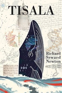
£9.99
Tirana Prefecture at 1:130, 000 in a series of handy size, waterproof & tear-resistant, contoured & GPS compatible road maps from the Tirana-based publishers Vektor. Landscape is presented by altitude colouring & contours lines at 100m intervals, with spot heights & a few more names of topographic features than found on Vektor’s 200K road maps of the country. National parks & nature reserves are prominently highlighted. The prefecture maps appear to show the same small local dirt roads as in the 200K series, but given the increase in scale do so with greater clarity & also provide more detailed GPS coordinates (latitude & longitude lines are drawn at 5’ intervals), useful when travelling across the more remote parts of the country. Railway lines are included & local airports are marked. Symbols highlight campsites, beaches, archaeological & historical sites, caves, etc. The maps also show subdivisions of prefectures & names of the communes, & indicate administrative status of towns. Map legend

Includes::
English. Please note: border crossings are prominently marked but beyond topographic colouring no road or other information is provided outside the country’s borders.

...
Archived Product
£12.99
Tired of London Tired of Life by Tom Jones is a wonderful showcase of 365 interesting activities to do in this vibrant city. Find out the art, literature & history that the capital has to offer, enjoy the variety of things to do from attending a Burns Night Scottish Dance in the middle of winter to lying on the beach at Ruislip Lido in summer, browsing Britain’s oldest bookshop, & savouring the cuisine from around the world, all this & more in London. The book

Includes::
pictures & drawings of London, is organised in chronological order, from the 1st of January to the 31st of December, each day with a suggestion for what to do. Ideal for the Londoner as well as for the tourist who has already visited the main sites, this guide will lead the readers to the hidden gems of the capital which make it such an inspiring & vibrant place.

...
Archived Product
£11.99
The Tyrol High Route between Mayrhofen & Merano on a waterproof & tear-resistant map at 1:50, 000 from Kompass. The double-sided map covers the whole area between these two popular holiday destinations & prominently highlights the route which weaves it way across the Zillertaler Alps, the Brenner Pass & the Texel/ Tessa Natural Park. Also marked are numerous other long-distance paths & local hiking trails, as well as cycling routes (including via Claudia Augusta), selected mountain bike trails & both cross-country & alpine ski routes. The map has contours at 40m intervals, enhanced by shading, graphic relief & spot heights, plus colouring and/or graphics to indicate different types of landscape & vegetation. National Parks & other protected areas are also marked. A very extensive range of symbols indicate different types of accommodation including campsites, youth hostels & shelters, sites for various other outdoor pursuits (climbing, paragliding, etc), recreational facilities, cycle hire & repair shops, etc. The map has a 2-km UTM grid. Comprehensive map legend included English. The map is accompanied by a 79-page booklet, IN GERMAN & ITALIAN ONLY, with stage-by-stage descriptions of the Tyrol High Route, including altitude profiles. The booklet, illustrated with numerous colour photos, also provides general information about the area & contact details of mountain huts along the trail. Kompass are Europe’s largest publishers of walking maps, with extensive coverage of hiking areas in other countries, all listed on our website under various series. ...
Archived Product
£6.95
Topographic coverage of mainland Spain at 1:50, 000 in the MTN50 (Mapa Topográfico Nacional) series from the Centro Nacional de Información Geografica, the country’s civilian survey organization. The maps have contours at 20m intervals, enhanced by relief shading, plus colouring and/or graphics to show different types of terrain, vegetation or land use. Boundaries of national parks & other protected areas are marked. In addition to all the usual information featured on topographic mapping at this scale, detailed presentation of the road & rail networks, rural tracks & paths, etc, the maps also show campsites & mountain refuges. On more recent editions some GRs, the official long-distance hiking routes, are also marked (although not as clearly as on hiking maps from other publishers). Each map covers 29.5x 18.5 km (with adjustments in the border or coastal areas). The maps have a 1-km UTM grid, plus margin ticks for latitude & longitude at 1` intervals. Map legend is in Spanish only.HOW TO CHOOSE THE RIGHT 50K MAP: all the titles in CNIG’s 200K Provincial Road Maps series at 1:200, 000 are overprinted with the grid for the 1:50, 000 maps & can be used to see the area covered by each 50K title. TO SEE THE LIST OF TITLES IN THIS SERIES PLEASE CLICK ON THE SERIES LINK.PLEASE NOTE
- MAP TITLES: the grids shown on our website serve both the civilian & the military 1:50, 000 topographic series. Although the areas covered by maps in both series are identical (apart from some border or coastal sheets), occasionally map titles differ – only one title is shown on the grid, usually the military one. In Galicia, the Basque country & in the Catalan speaking areas the tendency now is to use local place names rather than the often better known Castilian ones. Where possible, both versions are included in our titles. Map titles listed on our website are based on information received by us at the time of publication, but sometimes maps arrive showing a completely different title! As long as the map number is as ordered, the correct map has been supplied.
...
Archived Product
£4.25
Basic city map naming the main streets & marking places of interest. The main map showing Tirupati is at a scale of 1:13, 000 while the inset map of Tirumala is at 1:8, 500. A classified index proves handy to locate hotels, bus stations, museums & places of wirship among other things. The map comes with a booklet of useful & essential information for visitors, such as places to visit & useful contact telephone numbers. ...
Archived Product
£3.50
Tisbury in 1900 in a fascinating series of reproductions of old Ordnance Survey plans in the Alan Godfrey Editions, ideal for anyone interested in the history of their neighbourhood or family. The map is double-sided. The main map covers the centre of the village, extending southward to Wallmead Farm, westward to Tuckingmill, & eastward to Tisbury Mill. Features include St John`s church, railway with station, Wiltshire Brewery, police station, Tisbury Workhouse, The Quarry, Court Street, Overhouse Farm, River Nadder, etc. On the reverse is a good section of adjacent 64.11, extending coverage northward to include Place Farm & Tithe Barn, Tisbury House, Weaveland Farm, Prospect House, Ashleywood Farm. Coverage extends to the southern end of Fonthill Lake. About the Alan Godfrey Editions of the 25” OS Series Selected towns in Great Britain & Ireland are covered by maps showing the extent of urban development in the last decades of the 19th & early 20th century. The plans have been taken from the Ordnance Survey mapping & reprinted at about 15 inches to one mile (1:4, 340). On the reverse most maps have historical notes & many also include extracts from contemporary directories. Most maps cover about one mile (1.6kms) north/south, one & a half miles (2.4kms) across; adjoining sheets can be combined to provide wider coverage.FOR MORE INFORMATION & A COMPLETE LIST OF ALL AVAILABLE TITLES PLEASE CLICK ON THE SERIES LINK. ...
Archived Product
£11.50
Tirschenreuth in a series of GPS compatible recreational editions of the Bavarian topographic survey at 1:25, 000, with waymarked hiking trails & cycling routes, campsites & youth hostels, etc. Coverage

Includes::
Bärnau, Plößberg, Floß, Flossenbürg. Contours used in this map vary between 5 to 20m according to the terrain, with 20m interval predominantly used for hilly areas. Varied colouring show different types of landscape: woods, vineyards, fields etc. Maps in this series feature extensive overprint highlighting local & long-distance footpaths & cycle routes, including King Ludwig Way or different variants of the Way of St James, indicating their waymarking. Symbols highlight different types of accommodation (campsites, youth hostels, refuges, etc), sport & recreational facilities, various places of interest, etc. The maps have a 1-km UTM grid. Map legend & all the text are in German only. To see other titles in this series please click on the series link.

...
Archived Product
£6.95
Tisza Lakein a series of contoured hiking & recreational maps from the Budapest based Cartographia, with hiking routes & other tourist information, including in many titles street plans, cycling trails, etc. The maps have contours at 10m intervals with relief shading & spot heights, plus colouring and/or graphics to indicate different types of vegetation. An overprint highlights local hiking paths, with cycling routes also included in some titles. Symbols mark various places of interest, sport & recreational facilities, including campsites & other tourist accommodation, locations of petrol stations, etc. The maps show 1km lines of the country ...
Archived Product
£8.50
Tisza Lake at 1:50, 000 on a waterproof & tear-resistant recreational map from Cartographia in Budapest, highlighting kayaking routes on the lake & recommended cycling trails in the surrounding area, plus a street plan of Tiszafüred. On the lake navigation channels are marked, as well as navigation aids & obstacles, mooring places, etc. On l&, where topography is indicated by contours at & colouring/graphics for different types of vegetation, seven cycling routes are marked, from 18 to 68km long, with locations of cycle hire and/or repair facilities, fishing permit offices, beaches, etc. The map has no geographical coordinates. Map legend is in Hungarian & German only. On the reverse is a street plan of Tiszafüred, addresses of cycle hire and/or repair workshops, plus Hungarian language text about the area. ...
Archived Product
£8.50
The Tisza between Szeged & Tokaj presented in ten sections on a detailed map at 1:100, 000 from Cartographia, with an overprint highlighting a cycling route plus information for navigating along the river. Local towns are annotated with symbols indicating what facilities can be found there & places of interest are also highlighted. The map has no geographical coordinates. Map legend is in Hungarian & German only ...
Archived Product

Tisala

In 1960, David, a young London biologist researching in the Scottish Islands encounters a Blue Whale - Tisala. David becomes convinced that the whale is trying to communicate. With the help of an acoustic engineer a breakthrough is made. Two worlds meet. The whale, Tisala, wants David to help save the few remaining Blue Whales from being hunted to extinction. Set against the background history of whaling, the cruel slaughter of the greatest mammals on earth, and the struggle to stop it, the existence of a higher intelligence emerges. This is a story of love, passion and friendship in which the lives of Tisala and David are bound up with the problems of the modern world. In the sweep of twentieth century history, Tisala comes to understand that mankind threatens its own future as
well as much of life on Earth. In this philosophical and satirical novel Richard Seward Newton, through Tisala, turns his mind to the great issues facing humanity, from war, religion and population to education, economics and ethics, and seeks to distil the knowledge and wisdom that might lead to a happier world. It is an astonishing voyage of exploration in understanding the world in which we live.A profound, sad, hope-filled, epic story.
RIP - This product is no longer available on our network. It was last seen on 25.09.2019

This page now acts as a permanent archive for this product. Add more information using the comments box below to ensure it can still be found by future generations.

Use our search facility to see if it is available from an alternative contributor.
  • Availability: Out Of Stock
  • Supplier: Stanfords
  • SKU: 9781910369067
Availability: In Stock
£8.99

Product Description

In 1960, David, a young London biologist researching in the Scottish Islands encounters a Blue Whale
- Tisala. David becomes convinced that the whale is trying to communicate. With the help of an acoustic engineer a breakthrough is made. Two worlds meet. The whale, Tisala, wants David to help save the few remaining Blue Whales from being hunted to extinction. Set against the background history of whaling, the cruel slaughter of the greatest mammals on earth, & the struggle to stop it, the existence of a higher intelligence emerges. This is a story of love, passion & friendship in which the lives of Tisala & David are bound up with the problems of the modern world. In the sweep of twentieth century history, Tisala comes to understand that mankind threatens its own future as well as much of life on Earth. In this philosophical & satirical novel Richard Seward Newton, through Tisala, turns his mind to the great issues facing humanity, from war, religion & population to education, economics & ethics, & seeks to distil the knowledge & wisdom that might lead to a happier world. It is an astonishing voyage of exploration in understanding the world in which we live.A profound, sad, hope-filled, epic story.

Reviews/Comments

Add New

Intelligent Comparison

Oooops!
We couldn't find anything!
Perhaps this product's unique.... Or perhaps we are still looking for comparisons!
Click to bump this page and we'll hurry up.

Price History

Vouchers

No voucher codes found.
Do you know a voucher code for this product or supplier? Add it to Insights for others to use.

Facebook

Jargon Buster

Education - A term used to describe the act of learning a new skill or information
Blue - A primary colour
engineer - A professional engineering practitioner concerned with developing solutions for technological systems problems.
History - Anything that happens in the past. An acedemic subject.
World - A physical grouping, commonly used to describe earth and everything associated with ti
Earth - A planet third from the sun. Similar size to Venus but rich in water and complex life.
Set - a group of items usually related to one another. Some objects cannot function without the complete set of items.
Love - Someone who shows deep affection for someone else.

Supplier Information

Stanfords
Stanfords was established in 1853 and opened their iconic Covent Garden flagship store in 1901. They have become the top retailer of maps, travel books and accessories in the UK and arguably offer the largest selection of maps and travel books worldwide. Famous names such as Captain Robert Falcon Scott, Ranulph Fiennes and Michael Palin have purchased from Stanfords. They now have a shop in Bristol and both stores together with other venues operate a calendar of events including talks, book signings and exhibitions. As a specialist map retailer, the map selection is comprehensive and includes road maps, street maps and walking maps from worldwide destinations, as well as a selection of world atlases and wall maps. Books include travel guides and travel literature. Stanfords also stock globes, from miniatures made of blue marble to magnificent floor-standing globes. The website features a selection of interesting articles on travel topics.
Page Updated: 2023-11-12 20:15:36

Community Generated Product Tags

Oh No! The productWIKI community hasn't generated any tags for this product yet!
Menu