
 United Kingdom
 France
 Germany
 Netherlands
 Sweden
 USA
USA
 Italy
Italy
 Spain
Spain
More From Contributor


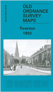
Tiverton 1903
Tiverton in 1903 in a fascinating series of reproductions of old Ordnance Survey plans in the Alan Godfrey Editions, ideal for anyone interested in the history of their neighbourhood or family. Selected towns in Great Britain and Ireland are covered by maps showing the extent of urban development in the last decades of the 19th and early 20th century.In this title: this detailed map covers the centre and south of Tiverton, stretching from St Peter's church southward to Howden Court, and from Gotham eastward to The Avenue. Features include GWR Exe Valley Branch with station, St Peter's church, St Paul's church, River Exe, Cranmore Castle camp, Collipriest, Little Silver area, St George's church, Howden Lace Factory, Cattle Market, Cold Harbour area, Brewery, Old Blundells,
The Firs, Castlebarn, Town Hall, town centre with individual buildings neatly shown, Loman Bridge, River Loman, etc. On the reverse are extracts from a 1906 directory, listing private residents, plus a timetable for the Exeter-Tilverton-Dulverton and Tiverton BranchesAbout the Alan Godfrey Editions of the 25
The Firs, Castlebarn, Town Hall, town centre with individual buildings neatly shown, Loman Bridge, River Loman, etc. On the reverse are extracts from a 1906 directory, listing private residents, plus a timetable for the Exeter-Tilverton-Dulverton and Tiverton BranchesAbout the Alan Godfrey Editions of the 25
Product Description
Reviews/Comments
Add New
Intelligent Comparison
Archived Product
Tiverton 1903 Stanfords
£3.50
Archived Product

Silvertown 1893 Stanfords
£3.50
Archived Product

Tipton 1904 Stanfords
£3.50
Archived Product

Taunton 1903 Stanfords
£3.50
Archived Product
Honiton 1903 Stanfords
£2.95
Archived Product
Honiton 1903 Stanfords
£3.50
Archived Product
Silvertown 1914 Stanfords
£3.50
Vouchers
No voucher codes found.
Do you know a voucher code for this product or supplier? Add it to Insights for others to use.
Do you know a voucher code for this product or supplier? Add it to Insights for others to use.
 Denmark