More From Contributor
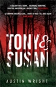
£7.99
Tongariro Northern Circuit & Tongariro Alpine Crossing in the Tongariro National Park at 1:60, 000 in a series of contoured & GPS compatible maps from New Topo NZ Ltd, with exceptionally vivid presentation of the terrain, routes clearly highlighted, & symbols to show locations of various facilities. The overprint highlights the two circuits, plus adjoining local routes. Contour interval is 20m. Maps in the series from New Topo NZ Ltd cover the country’s popular hiking & tramping areas. The maps have contours (20m in most titles
- please confirm in the individual description) enhanced by relief shading, plus colouring and/or graphics to indicate various types of the terrain & vegetation: glaciers, scree, lava flows, shingle, s&, swamps, exotic forest, scrub, native bush, etc. The overprint for the routes distinguishes, as appropriate, between tramping tracks & routes, walking tracks, & waymarked or unmarked trails. Symbols show facilities such huts, campsites, public toilets, viewpoints, car parks, etc. Where useful, the maps also have brief notes about hut reservations. All the titles are GPS compatible, most with a 1-km NZ national grid (GPS users can uses WGS84). To see all the titles in this series please click on the series link.
...
Archived Product
£9.50
Topographical survey of Belgium at 1:20, 000 from Nationaal Geografisch Instituut / Institut Géographique National, the country’s national survey organization. Each 20K map covers one quarter of the corresponding 1:50, 000 map (with adjustments in the border & coastal areas). The maps provide all the information expected of topographic mapping at this scale & in addition have an unusually large amount of vegetation and/or land use information (different types of woodlands, gardens, orchards, heath, etc). The maps have a 1-km UTM grid, with margin ticks for latitude & longitude at intervals of 1`. Map legend & a glossary of terms used on the maps include English. Stanfords keeps as regular stock 20K maps for the World War I battlefields around the Ypres, Messines & Passchendaele, & for the area of the Battle of Waterloo. The 1:20, 000 survey covers the whole of Belgium & maps for other regions can be supplied as special orders. To see the list of titles in this series please click on the series link.PLEASE NOTE: the Long-Distance Footpaths Map of Belgium at 1:300, 000 which shows the division of Belgium into the 50K survey sheets can also be used to see in more detail coverage by the 20K maps. ...
Archived Product
£11.99
Topographical survey of Belgium at 1:50, 000 from the country’s national survey organization, Nationaal Geografisch Instituut / Institut Géographique National. Contour interval varies according to the terrain, from 2.5 metres in the coastal areas to 10 metres in the Ardennes. The maps provide all the information expected of topographic mapping at this scale & in addition have an unusually large amount of vegetation and/or land use information (different types of woodlands, gardens, orchards, heath, etc). Each standard sheet covers Approx. 32 x 20 km / 20 x 12 miles, with larger maps published for the border or coastal areas. The maps have a 1-km UTM grid, with margin ticks for latitude & longitude at intervals of 1`. Map legend & a glossary of terms used on the maps include English.PLEASE NOTE: the Long-Distance Footpaths Map of Belgium at 1:300, 000 is overprinted with the grid for the 1:50, 000 topographic survey, showing the exact coverage of each sheet. Stanfords keeps as regular stock 50K maps for the World War I battlefields around the Ypres, Messines & Passchendaele, & for the area of the Battle of Waterloo. Maps for other regions can be supplied as special orders – to see the list of all the titles in this series please click on the series link. ...
Archived Product
£12.99
Topographic survey of France at 1:25, 000 in IGN`s excellent TOP25 / Série Bleue series. All the maps are GPS compatible, with a 1km UTM grid plus latitude & longitude lines at 5’ intervals. Contours are at 5m intervals except for mountainous areas where the maps have contours at 10m intervals, vividly enhanced by hill shading & graphics for rocky terrain. Colouring with graphics indicates different types of vegetation or land use (deciduous or coniferous forests, moors, orchards, vineyards, etc). PLEASE NOTE: coverage of France at this scale is currently being revised – the format & the presentation of each title are indicated by the letters at the end of its Sheet Reference number (e.g. 0416ET, 3531ETR, 1923SB, etc.)MAPS WITH FULL TOURIST OVERPRINT & AN ENGLISH MAP LEGEND: all TOP25 maps & the SB editions of Série Bleue have an overprint highlighting waymarked walking trails including long-distance GR routes &, where appropriate, ski routes. Symbols indicate campsites, gîtes d’etape, refuges, equestrian centres & other recreational facilities or sites, tourist information centres, cultural heritage, etc. Towns & locations of particular interest are highlighted.- ET or OT = single-sided TOP25 map covering approx. 29x 21 km / 18x 13 miles.- ETR or OTR = waterproof & tear resistant TOP25 map covering the same area as the corresponding ET or OT number, but double-sided, printed on a smaller size sheet with a good overlap between the sides.- SB = Série Bleue map with full tourist overprint; these maps, first introduced in summer 2014, each cover approx. 29x 24km / 18x 15 miles.SÉRIE BLEUE maps with numbers ending in E (Est) or O (Ouest): most editions now indicate the GR routes, but do not show any other tourist information. Map legend is in French only. Each map covers approx. 14x 20km / 9x 12 miles. ...
Archived Product
£8.99
Shortlisted for the Guardian First Book Award, the Saltire Scottish First Book of the Year & the Green Carnation Prize ` More than just one of the best debuts of the year; one of the best books of the year. It should do for Aberdeen what Trainspotting did for Edinburgh` Louise Welsh, Herald When Janie Ryan is born, she is destined to be the latest in a long line of Aberdeen fishwives. Ahead of her lies a life filled with feckless men, filthy council flats & bread & marge sandwiches. But Janie isn`t like the rest of them. She wants a different life. & Janie, born & bred for combat, is ready to fight for it. ...
Archived Product
£5.99
Tony Robinson takes you on a headlong gallop through time, pointing out all the most important, funny, strange, amazing, entertaining, smelly & disgusting bits about World War II! It`s history, but not as we know it! Find out everything you need to know in this brilliant, action-packed, fact-filled book, including:
- just how useful mashed potato is
- how the Battle of Britain was won
- what it takes to be a spy
- how D-Day was kept a surprise


...
Archived Product
£7.99
Tony Wheeler, founder of Lonely Planet, travelled through some of the world’s most repressive & dangerous regimes. Wheeler says, “ When Mr Bush produced his ‘ Axis of Evil’ list, my first thought was ‘I’ve got to go there.’ I’d visited Iran several times & found it to be a beautiful & welcoming country but I’d never managed to make it to North Korea or Iraq. North Korea’s utterly reclusive nature has always fascinated me & I’d had a long interest in the tourist potential of Iraq. So the Evil Axis trio formed the core of my Bad Lands & it was no trouble to come up with a half dozen other contenders.” As he travels to Afghanistan, Albania, Burma (Myanmar), Cuba, Libya, Iran, Iraq, North Korea & Saudi Arabia, Wheeler considers each country’s attitude to human rights & terrorism, to ask ‘what makes a country truly evil?’ & ‘how bad is bad?’. It’s a timely comment, written in his usual no-nonsense style, making for an absorbing & frank look at life in these countries. ...
Archived Product
£8.99
Following up on his travels detailed in Bad Lands, this time Tony Wheeler, the Lonely Planet founder, sets off to visit Dark Lands: Colombia, Haiti, Congo, Zimbabwe, Israel, Palestine, Pakistan, Papua New Guinea & Nauru. These places aren’t bad but in some ways conceal a shady story & could be thought of as ‘ Troubled States’, somewhat ‘ Failed States’, & sometimes ‘ Weird Lands’. In his interesting & educational journeys to understand how they got such reputations he sums up their stories with fairytales & legends. He finds examples of the birthday-suited king in Colombia as the war on drugs wages on, Rumpelstiltskin & King Midas in Papua New Guinea where gold brought unhappiness, Cinderella in Haiti though the prince has yet to turn up & Hydra whose severed heads either grow back or doubles, in the hills of Pakistan … He concludes that fairytales, though colourful stories, usually conceal a rather dark meaning to warn children of life’s dangers, the same way that history should teach adults about past’s mistakes. Yet, it seems, we let history repeat itself, as if we had forgotten both, the night time fairy tales & the history lessons! This is a very interesting & engaging account of travels in the Dark Lands, from an unusual perspective. Buy it now! ...
Archived Product
£2.95
Tonypandy & Trealaw in 1915 in a fascinating series of reproductions of old Ordnance Survey plans in the Alan Godfrey Editions, ideal for anyone interested in the history of their neighbourhood or family. Selected towns in Great Britain & Ireland are covered by maps showing the extent of urban development in the last decades of the 19th & early 20th century. In this title: the map covers most of Tynopandy & Trealaw, & the southern part of Llwyn-y-pia. Features include a stretch of Taff Vale Rhondda-Faw Branch with stations & sidings, Nantgwyn Coal Pit, football ground, Pandy Coal Pit, Anthony Coal Pit, Brith-weunydd, All Saints church, Mynydd Brith-weunydd, GWR Ely Valley Branch, Rhondda River, cinemas, St Andrew's church, tramways, etc. On the reverse is a commercial directory of Tonypandy. About the Alan Godfrey Editions of the 25 ...
Archived Product

Tony And Susan

Fifteen years ago, Susan Morrow left her first husband Edward Sheffield. One day, comfortable in her home, and her second marriage, she receives, entirely out of the blue, a parcel containing the manuscript of her ex-husband`s first novel. He writes asking her to read the book; she was always his best critic, he says. As Susan reads, she is drawn into the fictional life of his character Tony Hastings, a maths professor driving his family to their summer house in Maine. And as we read with her, so are we. As the Hastings` ordinary, civilized lives are disastrously, violently sent off course, Susan is plunged back into the past, forced to confront the darkness that inhabits her, and driven to name the fear that gnaws at her future and will change her life. Tony and Susan is a
dazzling achievement: simultaneously a riveting portrayal of the experience of reading and a page-turning thriller, written in startlingly arresting prose. It is also a novel about fear and regret, revenge and aging, marriage and creativity. It is simply unique.
RIP - This product is no longer available on our network. It was last seen on 25.09.2019

This page now acts as a permanent archive for this product. Add more information using the comments box below to ensure it can still be found by future generations.

Use our search facility to see if it is available from an alternative contributor.
  • External links may include paid for promotion
  • Availability: Out Of Stock
  • Supplier: Stanfords
  • SKU: 9781848870222
Availability: In Stock
£7.99

Product Description

Fifteen years ago, Susan Morrow left her first husband Edward Sheffield. One day, comfortable in her home, & her second marriage, she receives, entirely out of the blue, a parcel containing the manuscript of her ex-husband`s first novel. He writes asking her to read the book; she was always his best critic, he says. As Susan reads, she is drawn into the fictional life of his character Tony Hastings, a maths professor driving his family to their summer house in Maine. & as we read with her, so are we. As the Hastings` ordinary, civilized lives are disastrously, violently sent off course, Susan is plunged back into the past, forced to confront the darkness that inhabits her, & driven to name the fear that gnaws at her future & will change her life. Tony & Susan is a dazzling achievement: simultaneously a riveting portrayal of the experience of reading & a page-turning thriller, written in startlingly arresting prose. It is also a novel about fear & regret, revenge & aging, marriage & creativity. It is simply unique.

Reviews/Comments

Add New

Intelligent Comparison

Oooops!
We couldn't find anything!
Perhaps this product's unique.... Or perhaps we are still looking for comparisons!
Click to bump this page and we'll hurry up.

Price History

Vouchers

No voucher codes found.
Do you know a voucher code for this product or supplier? Add it to Insights for others to use.

Facebook

Jargon Buster

Blue - A primary colour
Summer - The season between Spring and Autumn. Usually the hottest season of the year
Day - The time it takes a planet or other space objects to complete one rotation.
Home - A place of permanent residence for families.
Experience - To gain further knowledge by practising.
Family - A group of people that live together made up from parents and children.

Supplier Information

Stanfords
Stanfords was established in 1853 and opened their iconic Covent Garden flagship store in 1901. They have become the top retailer of maps, travel books and accessories in the UK and arguably offer the largest selection of maps and travel books worldwide. Famous names such as Captain Robert Falcon Scott, Ranulph Fiennes and Michael Palin have purchased from Stanfords. They now have a shop in Bristol and both stores together with other venues operate a calendar of events including talks, book signings and exhibitions. As a specialist map retailer, the map selection is comprehensive and includes road maps, street maps and walking maps from worldwide destinations, as well as a selection of world atlases and wall maps. Books include travel guides and travel literature. Stanfords also stock globes, from miniatures made of blue marble to magnificent floor-standing globes. The website features a selection of interesting articles on travel topics.
Page Updated: 2023-11-12 20:15:36

Community Generated Product Tags

Oh No! The productWIKI community hasn't generated any tags for this product yet!
Menu