More From Contributor

£17.99
Norway, 1965. A team of young climbers from the north of England camp at the bottom of the tallest vertical rock face in Europe
-
...
Archived Product
£16.99
Sverigeserien is an outdoor map series consisting of 116 sheets with coverage of southern & central Sweden & the northern coastline. The map is suitable for outdoor activities such as hiking, excursions, trail running, hunting, fishing, riding, cycling, mountain biking, paddling, skating & much more. Every sheet covers an area of 45x 68km. These topographical maps in scale 1:50 000 contain all the information needed for outdoor activities: Terrain information, hiking trails, illuminated tracks, camping, shelters, golf courses, leisure baths, historical remains, roads in different categories, railway lines & much more. Easy to read topography with contour lines, vertical interval 5 m. Sverigeserien is a high-quality map series & is durable for frequent use! Updated content with map data from Lantmäteriet (National Land Survey of Sweden) & printed on Polyart which is water & tear resistant. This means that the map can be folded repeatedly without breaking & can withstand the challenging weather in Sweden during both winter & summer. Legend is in Swedish, English & German. ...
Archived Product
£23.99
Trollheimen area in Norway in a series of GPS compatible recreational maps at 1:50, 000 with cartography from Norway’s topographic survey & additional tourist information. Contours lines are drawn at 20m intervals. The overprint varies from title to title, but

Includes::
local footpaths, in some cases distinguishing between easy & more difficult trails, as well as mountain huts & campsites. Many titles also indicate cycle or ski routes, other accommodation possibilities, sport & recreational facilities, including alpine skiing slopes, places of interest, etc. The maps have a UTM grid & margin ticks giving latitude & longitude. Map legend

Includes::
English. Several titles have on the reverse additional tourist information, although in most cases in Norwegian only. To see the list of Turkart maps at 1:50, 000 & links to Turkart series at 25K, 100K & Hiking Sets please click on the series link above.


...
Archived Product
£23.99
This collection of national walking maps covers the mostpopular walking & hiking areas of Norway. The maps are Adapted for each specific area, & Contain hiking trails, cabins & local touring information. The maps are available in the following scales 1:25 000, 1:50 000, 1: 100 000. ...
Archived Product
£23.99
Map No. 10152, Tromsø, in the new topographic survey of Norway at 1:50, 000 covering the country on 195 double-sided sheets & first published by Nordeca in 2011
- 2012; fully GPS compatible, indicating waymarked footpaths, campsites, tourist huts, illuminated ski runs, etc. The maps, now published by Nordeca, the successors to Statens Kartverk & its subsequent owners the Ugland Group, are printed on light, waterproof & tear-resistant synthetic paper. Each map covers an area of 62x 45 kilometres (39 x 28 miles approx.), with a 2-km overlap between the sheets. The maps have contours at 20m intervals (10m glacier contours), plus colouring & graphics to show cultivated areas, bogs, forests, etc. In addition to all the information expected of topographic mapping at this scale the maps distinguish between waymarked & unmarked footpaths & show campsites, tourist huts (serviced/self service/no supplies), country hotels & restaurants, & illuminated ski trails. The series uses EUREF89 (WGS84) datum & the maps have a 1-km UTM grid. Map legend is in Norwegian & English. Each title comes in a sturdy protective card envelope.
...
Archived Product
£25.99
Topo 3000 Tromsø-Kvaløya by Nordeca AS is a detailed map covering an area of 64 x 47 km (over 3000 km 2). Here you will find the hiking routes easily, over the mountains, through the forest & along the roads. Lodgings are clearly marked to facilitate your planning. ...
Archived Product
£23.99
Map No. 10090, Trondheim, in the new topographic survey of Norway at 1:50, 000 covering the country on 195 double-sided sheets & first published by Nordeca in 2011
- 2012; fully GPS compatible, indicating waymarked footpaths, campsites, tourist huts, illuminated ski runs, etc. The maps, now published by Nordeca, the successors to Statens Kartverk & its subsequent owners the Ugland Group, are printed on light, waterproof & tear-resistant synthetic paper. Each map covers an area of 62x 45 kilometres (39 x 28 miles approx.), with a 2-km overlap between the sheets. The maps have contours at 20m intervals (10m glacier contours), plus colouring & graphics to show cultivated areas, bogs, forests, etc. In addition to all the information expected of topographic mapping at this scale the maps distinguish between waymarked & unmarked footpaths & show campsites, tourist huts (serviced/self service/no supplies), country hotels & restaurants, & illuminated ski trails. The series uses EUREF89 (WGS84) datum & the maps have a 1-km UTM grid. Map legend is in Norwegian & English. Each title comes in a sturdy protective card envelope.
...
Archived Product
£23.99
Trondheim area in Norway in a series of GPS compatible recreational maps at 1:50, 000 with cartography from Norway’s topographic survey & additional tourist information. Contours lines are drawn at 20m intervals. The overprint varies from title to title, but

Includes::
local footpaths, in some cases distinguishing between easy & more difficult trails, as well as mountain huts & campsites. Many titles also indicate cycle or ski routes, other accommodation possibilities, sport & recreational facilities, including alpine skiing slopes, places of interest, etc. The maps have a UTM grid & margin ticks giving latitude & longitude. Map legend

Includes::
English. Several titles have on the reverse additional tourist information, although in most cases in Norwegian only. To see the list of Turkart maps at 1:50, 000 & links to Turkart series at 25K, 100K & Hiking Sets please click on the series link above.


...
Archived Product
£2.50
Troon street map from Nicolson Maps, Scotland’s premier cartographic publisher, including Barassie, Dundonald, Loans, Symington. This title is part of the Street Guide Maps series, offering excellent & clear mapping of cities, towns & villages around the Great Britain. Please note, there is no actual written informative text, but the richness of symbology will provide visitors with ample information. The Street Guide Maps series from Nicolson Maps, Scotland’s premier cartographic publisher, offers excellent & clear mapping of cities, towns & villages around the UK. Most Nicolson’s maps are double-sided &, when applicable, cover additional locations on separate panels, each with a street index. The plans indicate, usually by different colours, primary routes plus A & B roads. Other roads, streets, tracks & paths are clearly shown as well as railway & bus stations. Symbols highlight location of various facilities, such as schools, libraries, places of worship, emergency services, petrol stations & car parks. Other places of interests like camping & caravan sites, historic buildings, museums, castles, information points etc. are also shown. ...
Archived Product

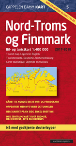
Troms And Finnmark - Tromso - Hammerfest - Kirkenes

North Troms and Finnmark: Tromsø - Hammerfest - Kirkenes region, the northernmost part of Norway, at 1:400, 000 from Cappelen, with street plans of central Hammerfest, Tromsø, Alta and Kirkenes, all annotated with places of interest, accommodation and various facilities.Road maps in the Cappelen’s regional series present topography by relief shading with numerous spot heights and names of various mountain ranges, peaks, valley, etc, plus colouring for woodlands and national parks. Road network, graded into seven types, includes selected cart tracks and indicates tolls, seasonal closures, roads closed to the public, steep gradients, etc. Driving distances are marked on main and on selected secondary roads. Also shown are selected footpaths, with some waymarked DNT
(Norwegian Trekking Association) routes annotated with approximate walking times. Railways lines are shown with stations and ferry connections are marked. The maps are particularly good at highlighting accommodation facilities, with an extensive range of symbols showing hotels, motels, campsites, youth hostels, etc, indicating different standards and categories. Other symbols show places of interest, viewpoints, bird colonies, etc. Latitude and longitude lines are drawn at 15’ and 30’ respectively. There is no index of place names. Map legend includes English. The maps now also provide street plans main cities and/or detailed enlargements of popular hiking areas - for more details please see the individual descriptions.To see other titles in this series please click on the
series link.
RIP - This product is no longer available on our network. It was last seen on 25.09.2019

This page now acts as a permanent archive for this product. Add more information using the comments box below to ensure it can still be found by future generations.

Use our search facility to see if it is available from an alternative contributor.
  • Availability: Out Of Stock
  • Supplier: Stanfords
  • SKU: 9788202547295
Availability: In Stock
£22.99

Product Description

North Troms & Finnmark: Tromsø
- Hammerfest
- Kirkenes region, the northernmost part of Norway, at 1:400, 000 from Cappelen, with street plans of central Hammerfest, Tromsø, Alta & Kirkenes, all annotated with places of interest, accommodation & various facilities. Road maps in the Cappelen’s regional series present topography by relief shading with numerous spot heights & names of various mountain ranges, peaks, valley, etc, plus colouring for woodlands & national parks. Road network, graded into seven types,

Includes::
selected cart tracks & indicates tolls, seasonal closures, roads closed to the public, steep gradients, etc. Driving distances are marked on main & on selected secondary roads. Also shown are selected footpaths, with some waymarked DNT (Norwegian Trekking Association) routes annotated with approximate walking times. Railways lines are shown with stations & ferry connections are marked. The maps are particularly good at highlighting accommodation facilities, with an extensive range of symbols showing hotels, motels, campsites, youth hostels, etc, indicating different standards & categories. Other symbols show places of interest, viewpoints, bird colonies, etc. Latitude & longitude lines are drawn at 15’ & 30’ respectively. There is no index of place names. Map legend

Includes::
English. The maps now also provide street plans main cities and/or detailed enlargements of popular hiking areas
- for more details please see the individual descriptions. To see other titles in this series please click on the series link.

Reviews/Comments

Add New

Intelligent Comparison

Oooops!
We couldn't find anything!
Perhaps this product's unique.... Or perhaps we are still looking for comparisons!
Click to bump this page and we'll hurry up.

Price History

Vouchers

No voucher codes found.
Do you know a voucher code for this product or supplier? Add it to Insights for others to use.

Facebook

Jargon Buster

Hiking - An outdoor activity envolving walking in nature
Railways - A set of tracks that have been laid for the purpose of trains to travel up and down them
Network - A link and communication between things. Often computers or people.
Road - a manmade lane or a path that is used to speed up travel.
Accommodation - A room in which someone can live in, for example in a hotel
Popular - Something that is admired and liked by many people.
Regional - An adjective to describe a set geographic area.
Individual - A single separate item or person.

Supplier Information

Stanfords
Stanfords was established in 1853 and opened their iconic Covent Garden flagship store in 1901. They have become the top retailer of maps, travel books and accessories in the UK and arguably offer the largest selection of maps and travel books worldwide. Famous names such as Captain Robert Falcon Scott, Ranulph Fiennes and Michael Palin have purchased from Stanfords. They now have a shop in Bristol and both stores together with other venues operate a calendar of events including talks, book signings and exhibitions. As a specialist map retailer, the map selection is comprehensive and includes road maps, street maps and walking maps from worldwide destinations, as well as a selection of world atlases and wall maps. Books include travel guides and travel literature. Stanfords also stock globes, from miniatures made of blue marble to magnificent floor-standing globes. The website features a selection of interesting articles on travel topics.
Page Updated: 2023-11-12 20:15:36

Community Generated Product Tags

Oh No! The productWIKI community hasn't generated any tags for this product yet!
Menu