More From Contributor

£30.00
Peter Dazeley has gained access to the hidden interiors of some of London`s most iconic buildings, from Tower Bridge to Battersea Power Station, Big Ben to the Old Bailey. His photographs of these buildings
- some derelict, but many still working
- are astonishing. Here is a collection of some 50 extraordinary locations, with a thoughtful text by Mark Daly which tells the story of how each of these places was created, how they are used, & what they reveal about the currents of power flowing through the city. Unseen London takes you backstage at some of the capital`s great theatres, into the changing rooms of some of our greatest temples of sport, into the heart of the Establishment, the boiler room of the city`s infrastructure & behind the scenes at some of the most opulent buildings in the Square Mile.

...
Archived Product
£32.00
A revised & updated edition for 2017:

Includes::
the royal palaces of Hampton Court, the Tower of London &

...
Archived Product
£26.00
You know what London looks like
- or so you think. You`ve seen the bright lights of Piccadilly Circus, the dull grey skies above.
...
Archived Product
£25.00
The first publication to bring together three major twentieth- century photographers
- Wolfgang Suschitzky, Dorothy Bohm & Neil
...
Archived Product
£20.00
THE NEW NOVEL FROM ORANGE PRIZE WINNER & INTERNATIONAL BESTSELLER BARBARA KINGSOLVER2016 Vineland Meet Willa Knox, a woman who stands braced against an upended world that seems to hold no mercy for her shattered life & family
- or the crumbling house that contains her.1871 Vineland Thatcher Greenwood, the new science teacher, is a fervent advocate of the work of Charles Darwin, & he is keen to communicate his ideas to his students. But those in power in Thatcher`s small town have no desire for a new world order. Thatcher & his teachings are not welcome. Both Willa & Thatcher resist the prevailing logic. Both are asked to pay a high price for their courage. But both also find inspiration -- & an unlikely kindred spirit -- in Mary Treat, a scientist, adventurer & anachronism.A testament to both the resilience & persistent myopia of the human condition, Unsheltered explores the foundations we build in life, spanning time & place to give us all a clearer look at those around us, & perhaps ourselves. It is a novel that speaks truly to our times.
...
Archived Product
£16.99
Real ladies do not travel
- or so it was once said. This collection of women`s travel writing dispels the notion by showing how
...
Archived Product
£11.99
One hundred years ago, in March 1909, Shackleton`s Nimrod Expedition came home safely. When Scott heard the news, he immediately contacted Tom Crean with the intention of planning his own adventure. & thus the Terra Nova Expedition was born. The remarkable Tom Crean ran away to sea aged fifteen & spent more time in the unexplored Antarctic than Scott or Shackleton, & was one of the few to serve & outlive both. Michael Smith`s original biography of this enigmatic figure spawned a Guinness ad, a one-man play that is still touring today & a children`s version of the Ice Man which has been chosen as the ` One Book` for literacy groups in Cork & Limerick. Tom`s story continues to fascinate people because of his extraordinary feats of survival, his bravery & his dedication to his comrades. At the end of his expedition days, Tom came home to Irel&, married & built a pub, the South Pole Inn, in Annascaul, County Kerry. He was an ordinary man who did incredible things, a modest man who became a hero. An unforgettable story of triumph over unparalleled hardship & deprivation. ...
Archived Product
£3.50
Unsworth & South East Radcliffe in 1932 in a fascinating series of reproductions of old Ordnance Survey plans in the Alan Godfrey Editions, ideal for anyone interested in the history of their neighbourhood or family. The map covers much of the straggling village of Unsworth & extends westward to the south-eastern tip of Radcliffe. Coverage stretches from St George`s church Unsworth westward to St Mary`s church Radcliffe, & from Radcliffe New Road northward to Blackford Bridge. Features include Bury New Road with tramway, Blackford Brow, Radcliffe Bleaching Works, Spring Water Bleach Works, Spring Clough Bleach Works, Elms Farm, Victoria Mills, Bombard`s Farm, Unsworth Hall, golf club, etc. On the reverse is a 1903 directory for Bury New Road, Hollins Lane, Lily Hill Street, Nipper Lane & Parr Lane. About the Alan Godfrey Editions of the 25” OS Series: Selected towns in Great Britain & Ireland are covered by maps showing the extent of urban development in the last decades of the 19th & early 20th century. The plans have been taken from the Ordnance Survey mapping & reprinted at about 15 inches to one mile (1:4, 340). On the reverse most maps have historical notes & many also include extracts from contemporary directories. Most maps cover about one mile (1.6kms) north/south, one & a half miles (2.4kms) across; adjoining sheets can be combined to provide wider coverage.FOR MORE INFORMATION & A COMPLETE LIST OF ALL AVAILABLE TITLES PLEASE CLICK ON THE SERIES LINK. ...
Archived Product
£19.99
The new Supertrail Maps show the best singletrails in Europe’s hottest mountain bike spots. These unique topographic maps make the knowledge of locals available to other mountain bikers. Consistent difficulty rating & useful additional information prevent the user from critical situations on the trails. The best singletrails in the best mountain bike spots throughout Europe
- this is the convincing formula of the brand new Supertrail Maps. For the first time ever, these unique topographic maps make the knowledge of locals available to others. All the trails on a map have been biked & rated in five difficulty levels for up- & downhill separately by specially trained authors. This consistent rating facilitates tour planning & spares a user from getting into sketchy situations on the trails. In addition to the difficulty rating, extraordinary nice trails are marked with a «highlight»-pictogram. The maps in a scale of 1:50 000 show all information required for tour planning & orienting oneself on the trails, such as: difficulty, highlight-trails, mountain railways with mountain bike transport, mountain bike shuttles, dangerous falls, restaurants, bike shops, emergency numbers & touristic infopoints. Thanks to the especially chosen map section, one map covers the whole area. The Supertrail Maps are printed on tear- & waterproof foil which makes them very sturdy. On the back of any map, additional information about the area & the use of a Supertrail Map are presented in two languages. Folded

Dimensions of 10x 15cm allow the map to fit into any pocket without squeezing.


...
Archived Product

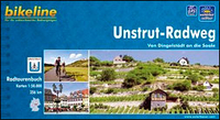
Unstrut Cycle Route: Dingelstädt - Naumburg - Halle (256km) Bikeline
Map/Guide

A 256-km long route along the Unstrut between Dingelstädt, Naumburg and Halle presented by the Verlag Esterbauer in guide with maps at 1:50, 000 showing the route and its variants. Extensive information is conveyed by symbols, indicating road surface, campsites and other accommodation, repair workshops, recreational facilities, places of interest, etc. A list of various types of accommodation facilities is included.IMPORTANT - PLEASE NOTE BEFORE ORDERING - ALL THE TEXT IN THIS TITLE IS GERMAN ONLY. MAP LEGEND INCLUDES ENGLISH (please see our sample image) and the information provided on the maps is sufficient to use this title without any knowledge of German.ABOUT THE BIKELINE SERIES: all the titles have been meticulously researched and are highly regarded in their native Germany.
Most titles, as indicated in their individual descriptions, also include a separate section listing selected accommodation, from hotels to campsites, youth hostels and rooms in private houses, all with addresses, telephone numbers and price range. Information on towns along each route includes a list of places of interest, with opening hours, etc. Several of the guides also have street plans.To see the list of other titles in the Bikeline series please click on the series link.
RIP - This product is no longer available on our network. It was last seen on 25.09.2019

This page now acts as a permanent archive for this product. Add more information using the comments box below to ensure it can still be found by future generations.

Use our search facility to see if it is available from an alternative contributor.
  • Availability: Out Of Stock
  • Supplier: Stanfords
  • SKU: 9783850002387
Availability: In Stock
£15.99

Product Description

A 256-km long route along the Unstrut between Dingelstädt, Naumburg & Halle presented by the Verlag Esterbauer in guide with maps at 1:50, 000 showing the route & its variants. Extensive information is conveyed by symbols, indicating road surface, campsites & other accommodation, repair workshops, recreational facilities, places of interest, etc. A list of various types of accommodation facilities is included.IMPORTANT
- PLEASE NOTE BEFORE ORDERING
- ALL THE TEXT IN THIS TITLE IS GERMAN ONLY. MAP LEGEND

Includes::
ENGLISH (please see our sample image) & the information provided on the maps is sufficient to use this title without any knowledge of German.ABOUT THE BIKELINE SERIES: all the titles have been meticulously researched & are highly regarded in their native Germany. Most titles, as indicated in their individual descriptions, also include a separate section listing selected accommodation, from hotels to campsites, youth hostels & rooms in private houses, all with addresses, telephone numbers & price range. Information on towns along each route

Includes::
a list of places of interest, with opening hours, etc. Several of the guides also have street plans. To see the list of other titles in the Bikeline series please click on the series link.

Reviews/Comments

Add New

Intelligent Comparison

Oooops!
We couldn't find anything!
Perhaps this product's unique.... Or perhaps we are still looking for comparisons!
Click to bump this page and we'll hurry up.

Price History

Vouchers

No voucher codes found.
Do you know a voucher code for this product or supplier? Add it to Insights for others to use.

Facebook

Jargon Buster

Germany - A country in Central Europe.
Telephone - A device used for communicating audio over long distances
Km - Kilometre. A unit of measurement equal to 1000 metres.
Road - a manmade lane or a path that is used to speed up travel.
Accommodation - A room in which someone can live in, for example in a hotel
Individual - A single separate item or person.

Supplier Information

Stanfords
Stanfords was established in 1853 and opened their iconic Covent Garden flagship store in 1901. They have become the top retailer of maps, travel books and accessories in the UK and arguably offer the largest selection of maps and travel books worldwide. Famous names such as Captain Robert Falcon Scott, Ranulph Fiennes and Michael Palin have purchased from Stanfords. They now have a shop in Bristol and both stores together with other venues operate a calendar of events including talks, book signings and exhibitions. As a specialist map retailer, the map selection is comprehensive and includes road maps, street maps and walking maps from worldwide destinations, as well as a selection of world atlases and wall maps. Books include travel guides and travel literature. Stanfords also stock globes, from miniatures made of blue marble to magnificent floor-standing globes. The website features a selection of interesting articles on travel topics.
Page Updated: 2023-11-12 20:15:36

Community Generated Product Tags

Oh No! The productWIKI community hasn't generated any tags for this product yet!
Menu