
 United Kingdom
 France
 Germany
 Netherlands
 Sweden
 USA
USA
 Italy
Italy
 Spain
Spain
More From Contributor


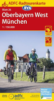
Upper Bavaria - Munich
Upper Bavaria - Munich area in a series of cycling maps of Germany from ADFC, the Allgemeiner Deutscher Fahrrad-Club, the official German cycling federation, with extensive overprint for long-distance and local cycling routes, plus a booklet with accommodation suggestions.The maps have contours at different intervals according to the type of the terrain, with steep roads also indicated by gradient marking. Colouring and/or graphics show various types of landscape: woods, vineyards, etc.An overprint highlights both the national long-distance cycling routes and the shorter local cycling trails, each clearly identified by symbols and abbreviations of its name. Sections with heavy traffic and/or poor road surface are identified and symbols indicates various facilities, such as railway
stations with cycle hire, cycle repair shops, campsites, youth hostels, shelters, sport and leisure facilities, etc.The series is currently being updated, and new editions have more finely drawn and easier to read cartography and a UTM grid. Earlier editions, as indicated against individual titles, show no coordinates. Map legend in both editions is in German only. Each title has a booklet, also in German only, with cycling/tourist information and Bett & Bike accommodation suggestions. In this title: new cartography and a UTM grid.
stations with cycle hire, cycle repair shops, campsites, youth hostels, shelters, sport and leisure facilities, etc.The series is currently being updated, and new editions have more finely drawn and easier to read cartography and a UTM grid. Earlier editions, as indicated against individual titles, show no coordinates. Map legend in both editions is in German only. Each title has a booklet, also in German only, with cycling/tourist information and Bett & Bike accommodation suggestions. In this title: new cartography and a UTM grid.
Product Description
Reviews/Comments
Add New
Intelligent Comparison
Archived Product
Upper Bavaria - Munich Cycling Map 26 Stanfords
£10.99
Archived Product
Bavarian Alps - Munich Stanfords
£9.95
Vouchers
No voucher codes found.
Do you know a voucher code for this product or supplier? Add it to Insights for others to use.
Do you know a voucher code for this product or supplier? Add it to Insights for others to use.
 Denmark