More From Contributor
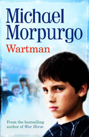
£4.95
Warsaw in the Wallpaper City Guide series, published by Phaidon & encompassing a collection of pocket-size guides dedicated to the best design elements in major cities. Compiled by experts at the Wallpaper magazine, the guides are widely recognized for appealing to design-conscious travellers & are aimed at those interested in art, design & architecture. Each guide identifies the best bars, restaurants, hotels, places to shop, leisure activities & excursions with a unique emphasis on the finest examples of unusual architecture & design. Each Wallpaper City Guide has the same layout, with separate tabs allowing readers & travellers to access individual sections easily. The tabs consist of Landmarks, Hotels, 24 Hours, Urban Life, Architour, Shopping, Sports & Escapes. High quality colour photographs appear alongside brief descriptions of each hotel, bar or attraction, highlighting distinctive & unusual styles of architecture & design. Extra pages are provided at the back of each guide, allowing readers to record their own notes & sketches. ...
Archived Product
£5.95
Warsaw`s northern environs in a series of detailed maps of Poland’s most popular recreational areas, showing waymarked hiking & cycling routes & various types of overnight accommodation, including local hotels, youth hostels, shelters & mountain huts, campsites, camping on local farms, etc. The maps also show various sport & recreational facilities: swimming pools, equestrian & watersport centres, etc. A wide range of other symbols highlight places of interest, local restaurants & bars, fuels supplies & other facilities. The base map is contoured (interval 5m, 10m, or 20m depending on the terrain), with, where appropriate, relief shading & graphic relief to enhance the presentation of the terrain. The maps also indicate various types of vegetation or land use. Road network

Includes::
unsurfaced country tracks & railway lines show local stations. The maps have 1km UTM grid. * Map legend

Includes::
English.** In this title:* popular recreational areas north of the capital
- Jezioro (Lake) Zegrzynskie & Kampinoski National Park. The map extends from the suburbs of the city in the south to Nasielsk in the north & from Nowy Dwór Mazowiecki in the west to Wolomin in the east.


...
Archived Product
£9.99
When a plucky little warthog sets out on an adventure, he meets all sorts of fascinating creatures, from two angry bees, all the way up to nine scared monkeys. All children will love lifting the flaps to count the hidden animals & they will ADORE following the ten muddy footprints which lead to...one rather fierce-looking lion! The funny, rhyming story of an intrepid little warthog who sets off on an ill-advised solo adventure, with a die-cut cover plus flaps & holes to reveal hidden characters on every spread. ...
Archived Product
£8.99
World War II affected every aspect of life on the British home front. From food rationing to air-raid shelters to war work, those left at home had to make huge changes in their day-to-day lives as Britain mobilised, economised, & saved in the name of Victory. ” Wartime Britain” takes a look at what these changes actually meant for families: how families coped when parents went to fight & children were evacuated; how pets were fed during rationing; the rise in road accidents during the blackout; &, the infamous `shelter cough`. ...
Archived Product
£8.99
In Pol&, in 1939, the comfortable, secure world of assimilated Jews is blown away by the invasion of the Third Reich. Maciek`s father disappears into the war`s vortex, leaving the orphaned child with his acerbic & beautiful Aunt Tania. It is her cool inventiveness, in their dramatic flight through a landscape of oppression, that will ensure their fragile survival. ...
Archived Product
£3.50
South Warwick in 1923 in a fascinating series of reproductions of old Ordnance Survey plans in the Alan Godfrey Editions, ideal for anyone interested in the history of their neighbourhood or family. The map covers the southern part of Warwick, stretching from the Castle eastward to Henry VIII Farm, & from Priory Road southward to Temple Hill. Features include Warwick Castle, King`s School, Myton Grange, Myton Crescent, Bridge End area, River Avon, St Nicholas church, St Mary`s church (split by east margin), St Nicholas Meadow, East Gate, Smith Street, part of High Street, etc. A section of a 1921 directory is on the reverse. About the Alan Godfrey Editions of the 25” OS Series Selected towns in Great Britain & Ireland are covered by maps showing the extent of urban development in the last decades of the 19th & early 20th century. The plans have been taken from the Ordnance Survey mapping & reprinted at about 15 inches to one mile (1:4, 340). On the reverse most maps have historical notes & many also include extracts from contemporary directories. Most maps cover about one mile (1.6kms) north/south, one & a half miles (2.4kms) across; adjoining sheets can be combined to provide wider coverage.FOR MORE INFORMATION & A COMPLETE LIST OF ALL AVAILABLE TITLES PLEASE CLICK ON THE SERIES LINK. ...
Archived Product
£3.50
North Warwick in 1923 in a fascinating series of reproductions of old Ordnance Survey plans in the Alan Godfrey Editions, ideal for anyone interested in the history of their neighbourhood or family. The map covers the northern part of Warwick, stretching from The Priory eastward to Milverton station & northward to Guy`s Cliffe House. Features include LMS station with Milverton station, Guy`s Cliffe House, Warwick & Napton Canal, tramway, Packmores area, Cliff Hill area, Emscote area, Workhouse, The Priory, The Cliff, Emscote Road, tramway depot, GWR railway with Warwick station, power station with siding, All Saints church, Emscote Mills, etc. A section of a 1921 directory is on the reverse. About the Alan Godfrey Editions of the 25” OS Series Selected towns in Great Britain & Ireland are covered by maps showing the extent of urban development in the last decades of the 19th & early 20th century. The plans have been taken from the Ordnance Survey mapping & reprinted at about 15 inches to one mile (1:4, 340). On the reverse most maps have historical notes & many also include extracts from contemporary directories. Most maps cover about one mile (1.6kms) north/south, one & a half miles (2.4kms) across; adjoining sheets can be combined to provide wider coverage.FOR MORE INFORMATION & A COMPLETE LIST OF ALL AVAILABLE TITLES PLEASE CLICK ON THE SERIES LINK. ...
Archived Product
£35.00
Highlights of this fully revised & updated guide are the magnificent medieval fortresses of Warwick & Kenilworth Castles, but this county is also home to some of the most significant developments of England`s postwar modern architecture, notably the rebuilt city center of Coventry destroyed in the Blitz. Leamington Spa has fine terraces of the Regency period but most famous of all is the market town of Stratford-upon-Avon where William Shakespeare was born & educated & the houses associated with his family are preserved. Also featured are the area`s greatest country houses, from Tudor Compton Wynyates & the moated Baddesley Clinton to Baroque Stoneleigh, Palladian Ragley, & Arbury Hall, one of the finest mansions of the Gothic Revival. ...
Archived Product
£5.95
Warwickshire in a series of colourful reproductions of attractive county maps by John Speede from about 1610-1611, printed on thick art paper & ideal for framing. Each title, 58 x 45cm / approx. 23” x 18”, is decorated with additional notes, drawings, coats of arms, street plans, etc. Little drawings are used to show locations of towns, larger villages, hills & woodlands or parks. Rivers & lakes are also drawn, as are boundaries of the administrative subdivisions with the names of the Hundreds. Surrounding the county are decorative panels filled with additional information which differs from title to title: street plans, coats of arms of notable local families, geographical features, notes about local history, etc. ...
Archived Product
£7.99
Warwickshire & The South Midlands Cycle Map at 1:110, 000 approx from Sustrans, including the Lias Line, the South Midlands Cycle Route, & the Grand Union Canal, plus five day rides: the Cotswold Tour, Long Buckby Circular, Royal Leamington Spa & Southam, Bicester to Winslow & return, & Kings Sutton Loop. Street plans show Coventry, Leamington Spa, Milton Keynes, Northampton & Rugby. Maps is this Sustrans series show all the National & Regional Cycle Network routes clearly numbered & have the colouring distinguishing between the on-road & traffic-free sections. The publishers’ own recommendations are shown in contrasting colour &, in most titles, are in addition presented on the reverse side on separate panels where each circuit is annotated with useful notes. The maps have contours & altitude colouring to show the topography, with additional gradient markings. Towns along the routes are annotated with symbols indicating what facilities can be found there. Also marked are various places of interest, on or near the routes, & railway lines are shown with stations for access to the routes by rail. On the reverse each title also provides large, clear city centre street plans of main towns, highlighting the Cycle Network and/or the recommended routes. Also included are contact details of tourist information centres. To see the list of titles in this series please click on the series link. ...
Archived Product

Wartman

A heart-warming and sensitive story about bullying from the former Children`s Laureate and bestselling author is given a brand new package. Dilly`s got a wart called George on his knee, causing him a lot of grief at school. Everyone laughs at him, his brother calls him `Wartman`, and he doesn`t know what to do - until he meets old Mr Ben, that is. Then everything changes! Funny and touching story from a multi award-winning author. Particularly suitable for dyslexic, reluctant and struggling readers
RIP - This product is no longer available on our network. It was last seen on 25.09.2019

This page now acts as a permanent archive for this product. Add more information using the comments box below to ensure it can still be found by future generations.

Use our search facility to see if it is available from an alternative contributor.
  • Availability: Out Of Stock
  • Supplier: Stanfords
  • SKU: 9781781120873
Availability: In Stock
£5.99

Product Description

A heart-warming & sensitive story about bullying from the former Children`s Laureate & bestselling author is given a brand new package. Dilly`s got a wart called George on his knee, causing him a lot of grief at school. Everyone laughs at him, his brother calls him ` Wartman`, & he doesn`t know what to do
- until he meets old Mr Ben, that is. Then everything changes! Funny & touching story from a multi award-winning author. Particularly suitable for dyslexic, reluctant & struggling readers

Reviews/Comments

Add New

Intelligent Comparison

Oooops!
We couldn't find anything!
Perhaps this product's unique.... Or perhaps we are still looking for comparisons!
Click to bump this page and we'll hurry up.

Price History

Vouchers

No voucher codes found.
Do you know a voucher code for this product or supplier? Add it to Insights for others to use.

Facebook

Jargon Buster

Heart - An organ that pumps blood around the body. Usually related to love.
Children - A young life form within the early stages of physical development,

Supplier Information

Stanfords
Stanfords was established in 1853 and opened their iconic Covent Garden flagship store in 1901. They have become the top retailer of maps, travel books and accessories in the UK and arguably offer the largest selection of maps and travel books worldwide. Famous names such as Captain Robert Falcon Scott, Ranulph Fiennes and Michael Palin have purchased from Stanfords. They now have a shop in Bristol and both stores together with other venues operate a calendar of events including talks, book signings and exhibitions. As a specialist map retailer, the map selection is comprehensive and includes road maps, street maps and walking maps from worldwide destinations, as well as a selection of world atlases and wall maps. Books include travel guides and travel literature. Stanfords also stock globes, from miniatures made of blue marble to magnificent floor-standing globes. The website features a selection of interesting articles on travel topics.
Page Updated: 2023-11-12 20:15:36

Community Generated Product Tags

Oh No! The productWIKI community hasn't generated any tags for this product yet!
Menu