
 United Kingdom
 France
 Germany
 Netherlands
 Sweden
 USA
USA
 Italy
Italy
 Spain
Spain
More From Contributor


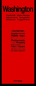
Washington DC Red Maps
Washington DC on a tourist street plan from Red Maps presented in a handy concertina format and printed on thick high quality paper, with thematic indexes for hotels, restaurants, shopping, museums, theatres, etc. The plan provides coverage of the central districts of the city extending from the Arlington Cemetery and the Georgetown University Campus in the west to Capitol Hill. On the reverse an enlargement shows the Downtown/Penn Quarter in greater detail. Also provided is a small road map of the city’s environs.The plan names tourist sights, important government buildings, entertainment venues, selected hotels and restaurants, etc. Also highlighted are main shopping streets. Washington’s metro stations and connections are very clearly indicated.The plan is accompanied by
several lists and recommendations: hotels, restaurants and shops arranged by district, government buildings, landmarks and monuments, etc. The index lists only a selection of neighbourhoods and streets.To see other street plans from Red Maps with similar presentation please click on the series link.
several lists and recommendations: hotels, restaurants and shops arranged by district, government buildings, landmarks and monuments, etc. The index lists only a selection of neighbourhoods and streets.To see other street plans from Red Maps with similar presentation please click on the series link.

Product Description
Reviews/Comments
Add New
Intelligent Comparison
Archived Product
Washington DC PopOut Map Stanfords
£3.99
Archived Product
Washington DC PopOut Map Stanfords
£3.99
Archived Product

Washington D.C. Rand McNally Stanfords
£7.99
Archived Product
Washington DC Children's Map Stanfords
£3.95
Archived Product
Washington DC Stanfords
£8.95
Archived Product

Washington DC Stanfords
£6.99
Archived Product
Washington DC Stanfords
£10.39
Archived Product
Washington DC Stanfords
£4.99
Vouchers
No voucher codes found.
Do you know a voucher code for this product or supplier? Add it to Insights for others to use.
Do you know a voucher code for this product or supplier? Add it to Insights for others to use.
 Denmark