
 United Kingdom
 France
 Germany
 Netherlands
 Sweden
 USA
USA
 Italy
Italy
 Spain
Spain
More From Contributor


Zagreb F&B
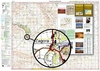
Zagreb on a large, indexed street plan from Freytag & Berndt covering the city with its outer suburbs and surrounding villages at 1:20, 000, with on the reverse the town centre in greater detail at 1:10, 000. Both plans shows tram routes with line numbers and stops, plus an additional a diagram presents the whole network.On one side the map at 1:20, 000 extends south and west to the A3 and A2 motorways, north to include Jablanovec, Medvednica Nature Park and Vgrovec Doji, and east to Sesvete. Important buildings are highlighted and symbols indicate various facilities and places of interest including selected hotels, embassies, petrol stations, etc. Street index is on the reverse. The reverse side also provides an enlargement showing the town centre in greater detail, plus a
diagram of the Tram network. Map legend includes English.
diagram of the Tram network. Map legend includes English.

Product Description
Reviews/Comments
Add New
Vouchers
No voucher codes found.
Do you know a voucher code for this product or supplier? Add it to Insights for others to use.
Do you know a voucher code for this product or supplier? Add it to Insights for others to use.
 Denmark