More From Contributor

£4.95
ADAC, Germany's equivalent of the British Automobile Association publishes an extensive series of street plans which provide detailed high-quality mapping of all the major towns & cities, including their outer suburbs. The plans name all the individual streets & indicate all the main landmarks & public buildings. All public transport facilities are shown: buses, trams, underground & overland rail lines. One way streets & car parks are indicated. Plans of larger cities include an enlargement for the city centre. The plans also show the administrative & postal divisions & have an extensive street index which, where appropriate, shows individual postal codes for each street. On the reverse, each plan has a road map at 1:100, 000, covering a very wide area around the city. Map legend

Includes::
English.

...
Archived Product
£8.99
Zwickau on a topographic map at 1:200, 000 from the Bundesamt für Kartographie und Geodäsie, Germany’s federal mapping agency. The map covers an area of Approx. 100 x 90km. This map is belongs to a series of 58 topographic maps from Bundesamt für Kartographie und Geodäsie, the federal cartographic agency of Germany responsible for topographic mapping at 1:200, 000 & maps at smaller scales (the more detailed topographic & leisure maps are prepared & published by the survey organizations of the individual states). Cartography is from the 200K topographic survey & the maps have very elegant, modern look whilst retaining the traditional German presentation of names of smaller towns & villages in italics. Contours are at 12, 5m intervals, enhanced by relief shading, with colouring for woodlands, moors, marches, vineyards & hop plantations. Waterways & rivers are also described in detail, with currents, waterfalls, dams, & jetties clearly marked. Road network, graded into five types, highlights in colour national & regional roads; no driving distances are marked Railway network is also shown in detail, with stations, goods only lines, etc. The maps show administrative boundaries of states & counties, & have a UTM grid plus margin ticks for latitude & longitude at 2’ intervals. Map legend is in German only. PLEASE NOTE: maps in this series provide an excellent presentation of the areas covered by them, with plenty of place names & detailed representation of the road network, & will appeal to anyone who likes quality cartography, but they are not necessarily the best option for holiday & business travel. To see other titles in this series please click on the series link. ...
Archived Product
£7.99
Falk, one of Germany`s leading publishers of street plans, produce their town plans in two different formats. Falk Extra plans are folded in a standard way, where the whole map can be opened to view the entire area it covers. For larger cities, the same mapping is also published with a special folding system designed to show only a small section of the map at one time. The whole map can be opened but it will be cut in several places. Many find these street plans very user-friendly & easier to handle than conventional maps. The plans, which cover towns with their outer suburbs, indicate main landmarks & public buildings & show all the public transport facilities, one way streets & car parks. Plans of lager cities include a separate map of the town centre at a more detailed scale & a diagram of the underground & the suburban rail network. The plans also show the postal divisions & have an extensive street index which, where appropriate, shows individual postal codes for each street. Map legend

Includes::
English. Falk Extra plans also include on the reverse a road map of the surrounding area.

...
Archived Product
£11.50
Zwiesel in a series of GPS compatible recreational editions of the Bavarian topographic survey at 1:25, 000, with waymarked hiking trails & cycling routes, campsites & youth hostels, etc. Coverage

Includes::
Bayerisch Eisenstein, Lohberg, Bodenmais, Langdorf, Lindberg. Contours used in this map vary between 5 to 20m according to the terrain, with 20m interval predominantly used for hilly areas. Varied colouring show different types of landscape: woods, vineyards, fields etc. Maps in this series feature extensive overprint highlighting local & long-distance footpaths & cycle routes, including King Ludwig Way or different variants of the Way of St James, indicating their waymarking. Symbols highlight different types of accommodation (campsites, youth hostels, refuges, etc), sport & recreational facilities, various places of interest, etc. The maps have a 1-km UTM grid. Map legend & all the text are in German only. To see other titles in this series please click on the series link.

...
Archived Product
£17.99
Kadaster, Holland`s national survey organization, produces one of the most attractive topographic surveys in Europe. The maps are very colourful, with their characteristic patchwork of polders & an unusually large amount of land use information: meadows, arable l&, different types of forest, marshes, sand dunes, etc. Contours are shown at 5-metre intervals with numerous spot heights &, with such a large part of the country below the sea level, ”spot depths”. Each map covers an area of Approx. 25 x 20 km / 15 x 12 miles, with some sheets slightly larger. The maps have a 1-km Dutch national grid, plus latitude & longitude at intervals of 1`. Map legend

Includes::
English.IMPORTANT
- PLEASE NOTE BEFORE ORDERING: both the west (W) & the east (O) sheet of each number has the same name, although the town after which the two maps are named appears only on one of the sheets. For example: maps 41W & 41O are both called Arnhem, although the city of Arnhem appears only on sheet 40W, etc. To see the list of titles available in this series please click on the series link.


...
Archived Product
£7.95
Map No. 21 W, Zwolle West, in the topographic survey of the Netherlands at 1:50, 000 from Kadaster. Holland's national survey organization produces one of the most attractive topographic surveys in Europe. The maps are very colourful, with their characteristic patchwork of polders & an unusually large amount of land use information: meadows, arable l&, different types of forest, marshes, sand dunes, etc. Contours are shown at 5-metre intervals with numerous spot heights &, with such a large part of the country below the sea level, spot depths. Each map covers an area of Approx. 25 x 20 km / 15 x 12 miles, with some sheets slightly larger. The maps have a 1-km Dutch national grid, plus latitude & longitude at intervals of 1'. Map legend

Includes::
English. IMPORTANT

...
Archived Product
£6.50
Zygos Footpaths map at 1:8, 000 covering are area between Zygos & Palia Kavala, north of the coastal town of Kavala in north-eastern Greece. The main map has contours at 20m intervals with shading & altitude colouring & shows local roads & tracks, waterfalls, spring taps, rest areas, etc. All place names are in both Greek & Latin alphabet. The map has a UTM grid. Map legend

Includes::
English. On the reverse the area east of Zygos is presented on two panels on contoured mapping but with no colourng, on highlighting a hiking tral, the other a cycle route.

...
Archived Product
£3.50
Zillebeke (28 NW 4 & NE 3
- ed. 3E) in a series of British Army trench maps from the WWI, reproduced by G.H. Smith & Son at Approx.
...
Archived Product
£3.50
Zonnebeke (28 NE 1
- ed. 7A) in a series of British Army trench maps from the WWI, reproduced by G.H. Smith & Son at Approx. 7/10th
...
Archived Product

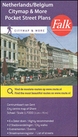
Zwolle Citymap & More

Zwolle in a series of handy size, detailed and indexed city centre street plans of main towns in the Netherlands and Flanders including Brussels from Falk, highlighting recommended walks and places of interest, with six best sights prominently marked and cross-referenced to brief descriptions. The plans also indicate publishers’ recommendations for shopping and/or bars and restaurants.The network of streets and small connecting passages is very clearly presented. Metro stations are marked and tram routes are shown with line numbers and stops. The plans show cycle paths and for drivers indicate main traffic arteries and car parks. Symbols show various facilities such as tourist information centres, markets, canal cruise offices, etc.On the reverse, the street index is accompanied
by a calendar of main events, a list of museums, plus contact details for publishers’ recommendations. Map legend and all the text about recommended sights, etc, include English.To see the list of other titles in this series please click on the series link.
RIP - This product is no longer available on our network. It was last seen on 25.09.2019

This page now acts as a permanent archive for this product. Add more information using the comments box below to ensure it can still be found by future generations.

Use our search facility to see if it is available from an alternative contributor.
  • Availability: Out Of Stock
  • Supplier: Stanfords
  • SKU: 9789028727793
Availability: In Stock
£5.50

Product Description

Zwolle in a series of handy size, detailed & indexed city centre street plans of main towns in the Netherlands & Flanders including Brussels from Falk, highlighting recommended walks & places of interest, with six best sights prominently marked & cross-referenced to brief descriptions. The plans also indicate publishers’ recommendations for shopping and/or bars & restaurants. The network of streets & small connecting passages is very clearly presented. Metro stations are marked & tram routes are shown with line numbers & stops. The plans show cycle paths & for drivers indicate main traffic arteries & car parks. Symbols show various facilities such as tourist information centres, markets, canal cruise offices, etc. On the reverse, the street index is accompanied by a calendar of main events, a list of museums, plus contact details for publishers’ recommendations. Map legend & all the text about recommended sights, etc, include English. To see the list of other titles in this series please click on the series link.

Reviews/Comments

Add New

Intelligent Comparison

Oooops!
We couldn't find anything!
Perhaps this product's unique.... Or perhaps we are still looking for comparisons!
Click to bump this page and we'll hurry up.

Price History

Vouchers

No voucher codes found.
Do you know a voucher code for this product or supplier? Add it to Insights for others to use.

Facebook

Jargon Buster

Calendar - A system for organising dates
Car - A machine used for transport which runs on roads
Size - is the measurement of how big an object is in space.
Network - A link and communication between things. Often computers or people.
Small - something that takes up less space than normal.
Tram - A large vehicle common in cities for public transport, also known as a cable car.

Supplier Information

Stanfords
Stanfords was established in 1853 and opened their iconic Covent Garden flagship store in 1901. They have become the top retailer of maps, travel books and accessories in the UK and arguably offer the largest selection of maps and travel books worldwide. Famous names such as Captain Robert Falcon Scott, Ranulph Fiennes and Michael Palin have purchased from Stanfords. They now have a shop in Bristol and both stores together with other venues operate a calendar of events including talks, book signings and exhibitions. As a specialist map retailer, the map selection is comprehensive and includes road maps, street maps and walking maps from worldwide destinations, as well as a selection of world atlases and wall maps. Books include travel guides and travel literature. Stanfords also stock globes, from miniatures made of blue marble to magnificent floor-standing globes. The website features a selection of interesting articles on travel topics.
Page Updated: 2023-11-12 20:15:36

Community Generated Product Tags

Oh No! The productWIKI community hasn't generated any tags for this product yet!
Menu