More From Contributor

£10.80
This soft protective carry case keeps your e Trex safe & sound when you are out & about. The clear window & joystick hole allow full functionality of your device & there is a handy belt clip. Velcro closure Belt clip Lanyard connection Clear vinyl window Compatible with e Trex 10, 20 & 30 ...
Archived Product
£350.99
The new Garmin Fenix 2 Performance Bundle gives you everything you need to supply you with accurate & reliable navigation & training information when you are out & about doing whatever you do. This really is the ultimate combination of outdoor navigation & fitness training devices that is suitable for just about any activity you can think of. The heart of the Fenix 2 is Garmins superb high sensitivity GPS receiver with Fast Fix technology that finds satellites quickly & then hangs onto their signal even in dense woodland or steep sided valleys. In navigation mode this brilliant device can track where youve been; guide you on your pre-programmed route & then guide you back to safety by recording a track log, a GPS bread crumb trail as you travel. You can also record waypoints, such as your start point, camp site, trig points & other POIs (points of interest). Using Garmin’s free Base Camp desktop route planning software you can create your trip at home, download the data to Fenix 2 & follow the navigation arrow to waypoints or the clearly visible route line to your destination. If the clag comes down & visibility is reduced, or you just want to re-trace your steps you can use the Trac Back facility to follow your automatically created tracklog trail back to safety. Other features to aid with navigation include a highly sensitive barometric altimeter & compass which are automatically calibrated using the GPS receiver to keep the data bang up to date & highly accurate. The built-in barometric altimeter provides elevation data to accurately monitor ascent & descent, & the barometer can be used to predict weather changes by showing short-term trends in air pressure so you can keep an eye on changing weather patterns & make the necessary changes to your plans. The 3-axis electronic compass does not require you to be moving to indicate an accurate bearing & if you require precise ambient temperature readings you can pair up the Fenix with an optional wireless Tempe temperature sensor. In running mode the Fenix 2 provides all the information any casual or serious runner requires to stay on top of their fitness or to improve performance. Pace, time, distance, interval training options, autolap & many more features are available to address the specific needs of trail runners, & the Fenix 2 also provides a dedicated profile showing shows data such as ascent, performance & vertical speed. You can even fully customise all of the available profiles to exactly match your specific training requirements. The Fenix 2 is an ideal training partner for all multi-sport activities such as Triathlon. During open water & indoor swimming the Fenix 2 tracks stroke count, intervals, distance, pace & more. During cycling the Fenix 2 provides detailed information by tracking cadence & power from optional sensors to complete your performance metrics. With the included heart rate monitor belt you can turn the Fenix 2 into a highly technical & sophisticated training data centre that can supply data & stats about your form & fitness. Perhaps the most important indication of your training progress is your VO2 Max measurement; this gives you an estimation of your actual fitness based on your performance & various values of your heart rate. Fenix 2 records your VO2 max so that you can see real fitness gains to inspire & motivate you to keep up your training. The Fenix 2 is even able to make a prediction on your race time based on your VO2 Max value. After your training the recovery advisor tells you how much time you need to recover from your last activity. The HRM belt & Fenix combination incorporates sophisticated sensor feedback on your running form to provide multiple advanced running metrics. Running dynamic data on your cadence, vertical oscillation & ground contact time are recorded to analyse your running ...
Archived Product
£90.00
Forerunner 10 is so easy to use, press of one button & you are off. Clear & easy to read screen that is fully customisable to show the data that is important to you on the same screen. This is Garmins lightest, most comfortable watch yet & can be worn as a regular watch, so you are always ready to go for a little run. The Forerunner 10 has a couple of cool training features such as Virtual Pacer, which compares your current running pace to your target. It also has a run/walk feature thats helpful if youre just starting out or your running plan

Includes::
walk breaks. You can upload your runs to  Garmin Connect to see your run on a map, get more detail on each mile & share it with friends for free. It is as simple as connecting your Forerunner 10 to you PC or Mac via the cable provided. With Garmin Connect & can go back & see your improvement week to week, month to month or even last year. Just to give you that very well deserved ego boost. The Forerunner 10 gives you a friendly beep at the completion of each mile; the flashing screen will notify you of your time for that mile so you can track your current performance. When you complete your run & save it, youll see a summary of how you did, including your total time, distance, average pace & calories. The watch even lets you know when you achieve a personal record, like your fastest mile or longest run to date. Its like having a little running coach on your wrist! Tracks distance, pace & calories Start running with the press a button Identifies personal records Virtual Pacer compares current pace to target Plan, review & share runs at Garmin Connect

...
Archived Product
£157.50
This is an easy to use, functional & lightweight GPS navigation device that due to its wrist mounting makes it perfect for when you need your hands free for more important duties.  Foretrex 401 automatically keeps track of your path & displays it as a dotted trail on the screen. This is called a Tracklog & is basically an electronic bread crumb trail of exactly where you have been. To follow the tracklog back to your start point, simply turn on Foretrexs Trac Back feature, & you can retrace your path back to where you started. The electronic compass & barometric altimeter will keep track of your bearing & altitude & the compass will show a bearing even when you are stationary. Specific locations can be stored in the internal memory as waypoints giving you the ability to instantly navigate to your favourite places & important references. You can then link up the stored Waypoints to create routes for the Foretrex to guide you. The Foretrex runs off replaceable & easily sourced AAA batteries, providing up to 17 hours of use. To further increase the capability of this superb device you can connect the Foretrex 401 to a wireless accessory, such as a heart rate monitor, cadence sensor, or clip it on your bike with the accessory bike mount. To keep track of your trip, connect your Foretrex to your PC or Mac with USB (Universal Serial Bus) to store your waypoints, routes & tracks on your computer. You also can share waypoints, routes & tracks wirelessly with certain Foretrex, Oregon & Montana devices, & it also is compatible with Garmin heart-rate monitors & cadence sensors. With a simple connection to your computer & the Internet, you can get detailed analysis of your activities & send tracks to your outdoor device using Garmin Connect. You can even view your activities on a map using Google Earth. In the box: Foretrex 401 Wrist expansion strap USB (Universal Serial Bus) cable Owners manual on disk Quick start manual ...
Archived Product
£9.00
Slip this case over your Garmin GSPMAP 62/64 & itll help to protect it from abrasion & scratches. The GPSMAP is a tough & rugged unit that is well suited to more adventurous activities, but it wouldnt hurt to offer it a bit more protection to keep it in tip top condition. ...
Archived Product
£40.50
Strap this Garmin Heart Rate Monitor around your chest to wirelessly transmit your actual heart rate to your compatible Garmin device. Use the HRM to maximise accurate training & weight loss data. This heart rate monitor is compatible with any ANT+ Garmin device & once paired up with your device the first time, will automatically recognise it each time after that. The heart rate module is housed in the plastic front part & this sits against your skin across your chest & is held in place with an elasticated adjustable strap. The fabric strap can be removed for washing. Check out the Trekitt range of compatible devices below. ...
Archived Product
£349.00
The Garmin GPSMAP 64s is a rugged & waterproof handheld navigation device that will withstand regular hard use & shrug off the elements. This incredibly powerful device packs a host of features to make your adventures more enjoyable & easier to navigate. This bundle

Includes::
the GPSMAP 64s and the GB Discoverer full UK Ordnance Survey 1:50k  Landranger digital mapping (worth £200.00). The heart of this brilliant device is Garmins High Sensitivity GPS receiver that is WAAS/EGNOS and GLONASS-enabled with  Hot Fix satellite prediction,  GPSMAP 64s locates your position quicker & more precisely thanks to the external high sensitivity quad helix antenna & hangs onto the signal even in heavy cover & steep sided valleys. The GPSMAP 64s can track both GPS and GLONASS satellites simultaneously. GLONASS is a system developed by the Russian Federation, & when linked to these satellites, the time it takes for the receiver to “lock on” to a position is (on average) Approx. 20 percent faster than using GPS alone. When using both GPS and GLONASS, the receiver has the ability to lock on to 24 more satellites than using standard GPS. The GPSMAP 64s features the usual Garmin full route navigation, with space to store up to 5000  Waypoints, 200 routes & automatically recorded  Tracklogs. This rugged device features a built-in 3-axis electronic compass with accelerometer tilt compensation that will show your bearing when you are stationary & not holding the device level. A barometric altimeter gives precise altitude readings & you can use it track weather patterns to help you plan your day & route accordingly. The display screen can be customised to show the data & all menus & data entry is accessed by the buttons, rather than touchscreen, making the GPSMAP easier to use with gloves on. Make use of Garmins free route planning software,   Base Camp, to create your routes comfortably & easily on your desktop & then down load them to the Oregon.  Base Camp will even use the 1:50k mapping from your device to make route planning even easier. With its sunlight readable display you can read the most detailed mapping in bright sunlight making navigation clear & easy.   As well as the included GB Discoverer mapping the Oregon also features a worldwide base map with relief shading for when you venture further afield. The Garmin GPSMAP 64s fully supports geocaching GPX files for downloading geocaches and details straight to your unit. Visit Open Caching.com to start your geocaching adventure. By going paperless, youre not only helping the environment but also improving efficiency. The GPSMAP stores & displays key information, including location, terrain, difficulty, hints & descriptions, which means no more manually entering coordinates & paper print outs. This versatile unit also has the ability to share your waypoints, tracks, routes and geocaches wirelessly with other compatible Garmin GPS devices. So now your friends also can enjoy your favourite hike or cache – simply press “send” to transfer your information to similar units. This rugged & waterproof GPS device will provide you with everything you need to navigate outdoors in a user friendly & intuitive design & is packed with additional features to make your adventures more enjoyable. In the box: GPSMAP 64s 16 hour Battery life 3.5GB internal memory Accepts Micro SD cards 250, 000 Preloaded geocaching.com chaches Carabiner clip USB (Universal Serial Bus) cabl

...
Archived Product
£339.00
The multi-award winning Oregon 600 is pretty much all the GPS you will ever need, this incredibly powerful device packs a host of features to make your adventures more enjoyable & easier to navigate. This bundle

Includes::
the Oregon 600 & the GB Discoverer full UK Ordnance Survey 1:50k Landranger digital mapping (worth £200.00). The heart of this brilliant device is Garmins High Sensitivity GPS receiver that is WAAS/EGNOS & GLONASS-enabled with Hot Fix satellite prediction, Oregon 600 locates your position quicker & more precisely & maintains its GPS location even in heavy cover & steep sided valleys. The Oregon 600 can track both GPS & GLONASS satellites simultaneously. GLONASS is a system developed by the Russian Federation, & when linked to these satellites, the time it takes for the receiver to “lock on” to a position is (on average) Approx. 20 percent faster than using GPS alone. When using both GPS & GLONASS, the receiver has the ability to lock on to 24 more satellites than using standard GPS. With its sunlight readable, touchscreen display you can read the most detailed mapping in bright sunlight & the reflective display adapts so that even in dull conditions information appears bright & clear. You can even use the multi-touch screen with most gloves on & in portrait & landscape modes. As well as the included GB Discoverer mapping the Oregon also features a worldwide base map with relief shading for when you venture further afield. The Oregon features the usual Garmin full route navigation, Waypoint management & Tracklogs & features a built-in 3-axis electronic compass with accelerometer tilt compensation that will show your bearing when you are stationary & not holding the device level. A barometric altimeter gives precise altitude readings & you can use it track weather patterns to help you plan your day & route accordingly. Make use of Garmins free route planning software, Base Camp, to create your routes comfortably & easily on your desktop & then down load them to the Oregon. Base Camp will even use the 1:50k mapping from your device to make route planning even easier. Garmin Oregon 600 supports geocaching GPX files for downloading geocaches & details straight to your unit. Visit Open Caching.com to start your geocaching adventure. By going paperless, youre not only helping the environment but also improving efficiency. The Oregon stores & displays key information, including location, terrain, difficulty, hints & descriptions, which means no more manually entering coordinates & paper print outs. In fact the Oregons massive internal memory means that you could download 4 million caches, so get every cache from Open Caching.com & start hunting. This versatile unit also has the ability to share your waypoints, tracks, routes & geocaches wirelessly with other compatible Garmin GPS devices. So now your friends also can enjoy your favourite hike or cache – simply press “send” to transfer your information to similar units. This rugged & waterproof GPS device will provide you with everything you need to navigate outdoors in a user friendly & intuitive design & is packed with additional features to make your adventures more enjoyable. Display Brightness. Reflective display technology uses external light, such as sunlight, in combination with the device’s LED backlight to increase brightness & viewing. Plus, you conserve power by not having to turn the backlight up. Dual Orientation. View maps & data in portrait or landscape mode. Landscape mode is great for typing & road navigation. Advanced Elevation Plot. Full Track view lets you see the entire elevation plot & quickly move your zoomed view to any place on the plot. Future Plot uses your mapping data to show what to expect ahead.

...
Archived Product
£211.50
Gregory packs carry heavy loads superbly, we have yet to find a pack that is more comfortable. The key to their success is how the suspension harness transfers the weight onto the hips maintaining a stable load bearing platform. The hip belt floats & rotates, automatically adjusting to the movements of your hips as you move. This keeps your centre of gravity aligned with your direction of movement & maximises the load transfer to the hips, not the shoulders. The shoulder straps & hip belt are made from non-compressing 3D Life Span EVA providing maximum comfort for the life of the pack. Faced with an ultra-soft fabric they will not wrinkle up or cause hot spots even when wearing lightweight clothing.   The Thermo Moulded EVA back panel features Gription technology on the lumbar pad which keeps the pack in place & optimises load transfer. Access to the main compartment is through the top lid or through the long U zip on the front of the pack which makes getting to your kit as easy as getting into a duffel.   The top lid can be completely removed & transformed into a waist pack, a brilliant feature when travelling.   Festooned with pockets so you won’t be short of places to stash your kit.   The large front pocket is the perfect place to stash soggy waterproofs or tent fabric & it can be fully compressed.   The brilliant hideaway water bottle pockets do just that, they hideaway when not required, & then pop out to swallow a large water bottle. Twin massive zipped side pockets, mesh hip belt pockets & zipped top lid pockets finish off the plethora of pockets. Single 7075-T6 aluminum stay 3D pre-curved harness & waistbelt components with Life Span EVA foam Auto-cant harness technology & Auto-fit waistbelt system Thermo-molded backpanel with elastomeric Gription technology on the lumbar pad Quick draw, easty-to-open drawstring system on main access Stash pocket on underside of the top lid Top lid can be removed & transformed into a bum bag Front pocket, twin side pockets & dual waistbelt pockets Hideaway water bottle pocket with bungee to secure bottles Hydration sleeve & side easy-to-feed ports for your hose DWR coated, water-resistant zippers & dual layer, wear-resistant bottom panel 210D DDR & 210D x 420D HD flat weave fabrics Response AFS Suspension ...
Archived Product
£58.50
The Miwok has been completely revamped for this season & is a truly versatile multi-activity pack with a very comfortable carry. No matter how hard or fast you go the Miwok will cling on to your back like its namesake on a star trooper! The thing that makes this pack so comfortable to carry is the Bio Sync harness; basically the shoulder straps & hip belt are attached with stretchy tendons that stretch & flex to allow a completely natural carrying experience. The supportive back panel features a mesh over perforated foam to maximise airflow whilst keeping the pack close fitting & stable. The main compartment is accessed via the long main zip that gives easy & quick access to all your stuff. Inside there are two mesh organiser pockets for all those essential bits & bobs. Externally there is a a top accessory pocket with an internal zipped security pocket, two deceptively large expanding side pockets, & two zipped hip belt pockets. On the front of the pack is a large expanding stretch pocket with an internal bungee closure making it perfect for bike helmets or soggy waterproofs. The Maya is fully hydration compatible & you can easily access your bladder via the external sleeve. Bio Sync Suspension technology to keep the pack moving with you for unrestricted motion Zippered main compartment with two internal mesh organizer pockets Zippered accessory pocket with internal security zip pocket Expandable stretch front pocket with tuck-away bungee closure fits helmets Dual external side pockets Dual quick-access waist belt pockets Hydration sleeve with external access Side compression straps Shoulder strap hydration tube clip Shoulder strap sunglass loop Low-profile safety light lash point   ...
Archived Product

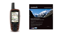
Garmin GPSMAP 62s GPS - GB Discoverer 1:50k Bundle

The Garmin GPSMAP 62s is a rugged and waterproof handheld navigation device that will withstand regular hard use and shrug off the elements. This incredibly powerful device packs a host of features to make your adventures more enjoyable and easier to navigate. This bundle includes the GPSMAP 62s and the GB Discoverer full UK Ordnance Survey 1:50k Landranger digital mapping (worth £200.00). The heart of this brilliant device is Garmins High Sensitivity GPS receiver that is WAAS/EGNOS and GLONASS-enabled with HotFix satellite prediction, GPSMAP 62s locates your position quicker and more precisely thanks to the external high sensitivity quad helix antenna and hangs onto the signal even in heavy cover and steep sided valleys. The GPSMAP 62s can track both GPS and GLONASS satellites
simultaneously. GLONASS is a system developed by the Russian Federation, and when linked to these satellites, the time it takes for the receiver to “lock on” to a position is (on average) approximately 20 percent faster than using GPS alone. When using both GPS and GLONASS, the receiver has the ability to lock on to 24 more satellites than using standard GPS. The GPSMAP 62s features the usual Garmin full route navigation, with space to store up to 2000 Waypoints, 200 routes and automatically recorded Tracklogs. This rugged device features a built-in 3-axis electronic compass with accelerometer tilt compensation that will show your bearing when you are stationary and not holding the device level. A barometric altimeter gives precise altitude readings and you can use it track
weather patterns to help you plan your day and route accordingly. The display screen can be customised to show the data and all menus and data entry is accessed by the buttons, rather than touchscreen, making the GPSMAP easier to use with gloves on. Make use of Garmins free route planning software, BaseCamp, to create your routes comfortably and easily on your desktop and then down load them to the Oregon. BaseCamp will even use the 1:50k mapping from your device to make route planning even easier. With its sunlight readable display you can read the most detailed mapping in bright sunlight making navigation clear and easy.  As well as the included GB Discoverer mapping the Oregon also features a worldwide base map with relief shading for when you venture further afield. The Garmin
GPSMAP 62s fully supports geocaching GPX files for downloading geocaches and details straight to your unit. Visit OpenCaching.com to start your geocaching adventure. By going paperless, youre not only helping the environment but also improving efficiency. The GPSMAP stores and displays key information, including location, terrain, difficulty, hints and descriptions, which means no more manually entering coordinates and paper print outs. This versatile unit also has the ability to share your waypoints, tracks, routes and geocaches wirelessly with other compatible Garmin GPS devices. So now your friends also can enjoy your favourite hike or cache – simply press “send” to transfer your information to similar units. This rugged and waterproof GPS device will provide you with
everything you need to navigate outdoors in a user friendly and intuitive design and is packed with additional features to make your adventures more enjoyable. In the box: GPSMAP 62s Carabiner clip USB cable Quickstart Guide GB Discoverer 1:50k full GB coverage on microSD card
RIP - This product is no longer available on our network. It was last seen on 31.03.2015

This page now acts as a permanent archive for this product. Add more information using the comments box below to ensure it can still be found by future generations.

Use our search facility to see if it is available from an alternative contributor.
  • Availability: Out Of Stock
  • Supplier: Trekitt
  • SKU: 2392
Availability: In Stock
£270.00

Product Description

The Garmin GPSMAP 62s is a rugged & waterproof handheld navigation device that will withstand regular hard use & shrug off the elements. This incredibly powerful device packs a host of features to make your adventures more enjoyable & easier to navigate. This bundle

Includes::
the GPSMAP 62s & the GB Discoverer full UK Ordnance Survey 1:50k Landranger digital mapping (worth £200.00). The heart of this brilliant device is Garmins High Sensitivity GPS receiver that is WAAS/EGNOS & GLONASS-enabled with Hot Fix satellite prediction, GPSMAP 62s locates your position quicker & more precisely thanks to the external high sensitivity quad helix antenna & hangs onto the signal even in heavy cover & steep sided valleys. The GPSMAP 62s can track both GPS & GLONASS satellites simultaneously. GLONASS is a system developed by the Russian Federation, & when linked to these satellites, the time it takes for the receiver to “lock on” to a position is (on average) Approx. 20 percent faster than using GPS alone. When using both GPS & GLONASS, the receiver has the ability to lock on to 24 more satellites than using standard GPS. The GPSMAP 62s features the usual Garmin full route navigation, with space to store up to 2000 Waypoints, 200 routes & automatically recorded Tracklogs. This rugged device features a built-in 3-axis electronic compass with accelerometer tilt compensation that will show your bearing when you are stationary & not holding the device level. A barometric altimeter gives precise altitude readings & you can use it track weather patterns to help you plan your day & route accordingly. The display screen can be customised to show the data & all menus & data entry is accessed by the buttons, rather than touchscreen, making the GPSMAP easier to use with gloves on. Make use of Garmins free route planning software, Base Camp, to create your routes comfortably & easily on your desktop & then down load them to the Oregon. Base Camp will even use the 1:50k mapping from your device to make route planning even easier. With its sunlight readable display you can read the most detailed mapping in bright sunlight making navigation clear & easy.   As well as the included GB Discoverer mapping the Oregon also features a worldwide base map with relief shading for when you venture further afield. The Garmin GPSMAP 62s fully supports geocaching GPX files for downloading geocaches & details straight to your unit. Visit Open Caching.com to start your geocaching adventure. By going paperless, youre not only helping the environment but also improving efficiency. The GPSMAP stores & displays key information, including location, terrain, difficulty, hints & descriptions, which means no more manually entering coordinates & paper print outs. This versatile unit also has the ability to share your waypoints, tracks, routes & geocaches wirelessly with other compatible Garmin GPS devices. So now your friends also can enjoy your favourite hike or cache – simply press “send” to transfer your information to similar units. This rugged & waterproof GPS device will provide you with everything you need to navigate outdoors in a user friendly & intuitive design & is packed with additional features to make your adventures more enjoyable. In the box: GPSMAP 62s Carabiner clip USB (Universal Serial Bus) cable Quickstart Guide GB Discoverer 1:50k full GB coverage on micro SD card

Reviews/Comments

Add New

Intelligent Comparison

Oooops!
We couldn't find anything!
Perhaps this product's unique.... Or perhaps we are still looking for comparisons!
Click to bump this page and we'll hurry up.

Price History

Oooops!
We couldn't find any historical pricing!

Vouchers

No voucher codes found.
Do you know a voucher code for this product or supplier? Add it to Insights for others to use.

Facebook

Jargon Buster

USB - Universal Serial Bus
GPS - Global Positioning System - Global position using satellites
Paper - A thin sheet mainly used for writing. Available in a variety of colours. Made mainly from wood pulp.
UK - United Kingdom - An island nation in Europe
Digital - A system that uses only 0s and 1s to transmit data
Key - A physical or virtual device or code used for opening something
Cable - A series of wires bonded to form a single thread
Waterproof - Resistant to water, usualy specified by depth in metres
Friends - A close associate or a popular US based sitcom about a group of friends
heavy - A concept of weight indicating an item may require some effort to lift or move
Day - The time it takes a planet or other space objects to complete one rotation.
Weather - is the change of an atmospheres conditions.
Heart - An organ that pumps blood around the body. Usually related to love.
USB - Universal Serial Bus. A method of connecting a device to a computer
Adventure - an undertaking of an exciting challenge or experience.
Quad - Multiple items, meaning four
Versatile - Something that can be adapted to various different tasks.
Precise - A measurement on the accuracy of something
Versatile - Something that is able to adapt to its surroundings or its requirements.
Altitude - Something that can be quite high in relation to sea or ground level.
Design - A drawing or styles that shows the look and functionality of something before its made.
Print - A mechanical process of putting text onto paper. It can also relate to a pattern on an item.
Environment - The conditions and surrounding area.

Supplier Information

Trekitt
Page Updated: 2015-04-29 04:02:53

Community Generated Product Tags

Oh No! The productWIKI community hasn't generated any tags for this product yet!
Menu