
 United Kingdom
 France
 Germany
 Netherlands
 Sweden
 USA
USA
 Italy
Italy
 Spain
Spain
More From Contributor


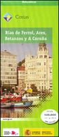
A Coruña - Ferrol Coast Of Galicia 50K CNIG Map
The coast of Galicia between the towns of A Coruña and Ferrol on a detailed, GPS compatible topographic map at 1:50, 000 from the country’s civilian survey organization, with additional nautical information in the bays of Ferrol, Ares, Betanzos and Coruña. The map has the cartography of Spain’s civilian topographic survey at 1:50, 000 with contours at 20m intervals enhanced by relief shading, plus coloring and graphics to provide an excellent presentation of the terrain and land use. Road and rail information and other detail expected of topographic mapping at this scale are marked. The map also shows nautical information such as sea depth, navigational channels, lighthouses and buoys, etc, but PLEASE NOTE: this title is sold by Stanfords as a topographic map and not as a
navigational chart of the area. The map has a 1-km UTM grid plus latitude and longitude margin ticks at 1’ intervals. Map legend is in Spanish only. To see other titles in this series please click on the series link.
navigational chart of the area. The map has a 1-km UTM grid plus latitude and longitude margin ticks at 1’ intervals. Map legend is in Spanish only. To see other titles in this series please click on the series link.

Product Description
Reviews/Comments
Add New
Vouchers
No voucher codes found.
Do you know a voucher code for this product or supplier? Add it to Insights for others to use.
Do you know a voucher code for this product or supplier? Add it to Insights for others to use.
 Denmark