More From Contributor

£5.99
Black Sea resorts of Ahtopol & Sinemorets on a double-sided street plan from Domino, each with a brief description of the town & its sights, plus a list of hotels & other tourist accommodation. The two towns are shown with names of main streets in both Cyrillic & Latin alphabet. Symbols indicate locations of hotels, shopping centre, petrol stations, etc. Accompanying lists of hotels include contact details. Also provided is a road map at 1:85, 000 of the coast north & south of these two resorts showing hiking trails. Map legend & the text include English. ...
Archived Product
£11.50
Aichach in a series of GPS compatible recreational editions of the Bavarian topographic survey at 1:25, 000, with waymarked hiking trails & cycling routes, campsites & youth hostels, etc. Contours used in this map vary between 5 to 20m according to the terrain, with 20m interval predominantly used for hilly areas. Varied colouring show different types of landscape: woods, vineyards, fields etc. Maps in this series feature extensive overprint highlighting local & long-distance footpaths & cycle routes, including King Ludwig Way or different variants of the Way of St James, indicating their waymarking. Symbols highlight different types of accommodation (campsites, youth hostels, refuges, etc), sport & recreational facilities, various places of interest, etc. The maps have a 1-km UTM grid. Map legend & all the text are in German only. To see other titles in this series please click on the series link. ...
Archived Product
£8.99
Do you know why Africa is so poor? What really happens to your charity money? Why do trade rules fail African countries & yet cost you too? We`ve heard it all before: the corrupt leaders, heartless global corporations, the wicked World Bank. But the answers are much closer to home...and so are the solutions. When Giles Bolton began working in the world of aid & development, he travelled to Africa convinced that he could solve problems, save villages & sing songs with the locals under a shimmering sunset. The reality proved rather less romantic, & far more shocking... Aid & Other Dirty Business is a radical, brilliantly readable & totally original approach to the seemingly unending problem of poverty in Africa. It may change your life, but, more importantly, it will help you change the lives of others. ...
Archived Product
£14.99
Aigüestortes i Estany de Sant Maurici National Park on a 2-map set from Editorial Alpina containing two of the publishers’ 1:25, 000 maps: Val de Boi & Sant Maurici. Both maps have contours at 10m intervals, enhanced by relief shading with plenty of spot heights, plus colouring for different types of vegetation and/or land use. An overprint highlights walking paths, indicating where appropriate their PR or GR numbers. Symbols show various types of accommodation (hotels, farms, refuges, campsites, etc), picturesque locations & other places of interest. The maps have a 1km UTM grid plus latitude & longitude margin ticks at 1’ intervals. Map legend

Includes::
English.PLEASE NOTE: each of the two maps is also available separately, accompanied by a booklet with English language descriptions of several recommended hiking trails, other recreational information, contact details for mountain refuges, etc. To see the list of currently available titles in this extensive Editorial Alpina hiking series please click on the series link.

...
Archived Product
£9.99
Aigüestortes i Estany de Sant Maurici National Park at 1:25, 000 on a contoured & GPS compatible map from IGN/CNIG with cartography from their topographic survey of Spain. The map is accompanied by a 96-page Spanish language guide with descriptions of walks, contact details for recommended accommodation, etc. The map has contours at 10m intervals enhanced by relief shading, plus colouring & graphics to show different types of vegetation. Hiking trails are highlighted, indicating routes which are described in the guide. A wide range of symbols indicate various facilities & places of interest, including different types of accommodation (campsites, refuges, etc), restaurants, sites for other recreational pursuits (climbing, caving, paragliding, etc), petrol stations, bus connections, etc. The map has a 1km UTM grid & margin ticks for latitude & longitude. Map legend is in Spanish only. The accompanying guide is in Spanish & describes 25 routes within the national park. The guide provides phone numbers for various accommodation options, general notes about the area, etc. To see other titles in this series please click on the series link. ...
Archived Product
£12.99
Topographic survey of France at 1:25, 000 in IGN`s excellent TOP25 / Série Bleue series. All the maps are GPS compatible, with a 1km UTM grid plus latitude & longitude lines at 5’ intervals. Contours are at 5m intervals except for mountainous areas where the maps have contours at 10m intervals, vividly enhanced by hill shading & graphics for rocky terrain. Colouring with graphics indicates different types of vegetation or land use (deciduous or coniferous forests, moors, orchards, vineyards, etc). PLEASE NOTE: coverage of France at this scale is currently being revised – the format & the presentation of each title are indicated by the letters at the end of its Sheet Reference number (e.g. 0416ET, 3531ETR, 1923SB, etc.)MAPS WITH FULL TOURIST OVERPRINT & AN ENGLISH MAP LEGEND: all TOP25 maps & the SB editions of Série Bleue have an overprint highlighting waymarked walking trails including long-distance GR routes &, where appropriate, ski routes. Symbols indicate campsites, gîtes d’etape, refuges, equestrian centres & other recreational facilities or sites, tourist information centres, cultural heritage, etc. Towns & locations of particular interest are highlighted.- ET or OT = single-sided TOP25 map covering approx. 29x 21 km / 18x 13 miles.- ETR or OTR = waterproof & tear resistant TOP25 map covering the same area as the corresponding ET or OT number, but double-sided, printed on a smaller size sheet with a good overlap between the sides.- SB = Série Bleue map with full tourist overprint; these maps, first introduced in summer 2014, each cover approx. 29x 24km / 18x 15 miles.SÉRIE BLEUE maps with numbers ending in E (Est) or O (Ouest): most editions now indicate the GR routes, but do not show any other tourist information. Map legend is in French only. Each map covers approx. 14x 20km / 9x 12 miles. ...
Archived Product
£18.99
Topographic survey of France at 1:25, 000 in IGN`s excellent TOP25 / Série Bleue series. All the maps are GPS compatible, with a 1km UTM grid plus latitude & longitude lines at 5’ intervals. Contours are at 5m intervals except for mountainous areas where the maps have contours at 10m intervals, vividly enhanced by hill shading & graphics for rocky terrain. Colouring with graphics indicates different types of vegetation or land use (deciduous or coniferous forests, moors, orchards, vineyards, etc). PLEASE NOTE: coverage of France at this scale is currently being revised – the format & the presentation of each title are indicated by the letters at the end of its Sheet Reference number (e.g. 0416ET, 3531ETR, 1923SB, etc.)MAPS WITH FULL TOURIST OVERPRINT & AN ENGLISH MAP LEGEND: all TOP25 maps & the SB editions of Série Bleue have an overprint highlighting waymarked walking trails including long-distance GR routes &, where appropriate, ski routes. Symbols indicate campsites, gîtes d’etape, refuges, equestrian centres & other recreational facilities or sites, tourist information centres, cultural heritage, etc. Towns & locations of particular interest are highlighted.- ET or OT = single-sided TOP25 map covering approx. 29x 21 km / 18x 13 miles.- ETR or OTR = waterproof & tear resistant TOP25 map covering the same area as the corresponding ET or OT number, but double-sided, printed on a smaller size sheet with a good overlap between the sides.- SB = Série Bleue map with full tourist overprint; these maps, first introduced in summer 2014, each cover approx. 29x 24km / 18x 15 miles.SÉRIE BLEUE maps with numbers ending in E (Est) or O (Ouest): most editions now indicate the GR routes, but do not show any other tourist information. Map legend is in French only. Each map covers approx. 14x 20km / 9x 12 miles. ...
Archived Product

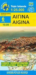
Aigina / Aegina Anavasi 10.00

Aegina at 1:25, 000 on light, waterproof and tear-resistant, GPS compatible and contoured map from Anavasi, with on the reverse a simplified map of the island for sightseeing and recommended hiking trails.On one side is a contoured map of the island (interval 20m), with additional altitude colouring and shading. All place names are in both Greek and Latin alphabets. The marking for footpaths distinguishes between wide, narrow and faint paths. Road network indicates unsurfaced roads and dirt roads in poor condition. Distances are marked on main roads. Symbols indicate beaches, marinas, churches, etc. The map has a 1km UTM grid and margin tick for latitude and longitude at 1’. Map legend includes English.On the reverse is a simplified map of the island, without contours but with
relief shading to make roads and recommended trail stand out better from the background. Eight locations are illustrated by colour photos with notes, and brief descriptions are provided for two hiking trails. All the text is bilingual Greek / English.To see which other Greek islands are covered by maps from Anavasi, please click on the series link.
RIP - This product is no longer available on our network. It was last seen on 25.09.2019

This page now acts as a permanent archive for this product. Add more information using the comments box below to ensure it can still be found by future generations.

Use our search facility to see if it is available from an alternative contributor.
  • External links may include paid for promotion
  • Availability: Out Of Stock
  • Supplier: Stanfords
  • SKU: 9789609412858
Availability: In Stock
£5.99

Product Description

Aegina at 1:25, 000 on light, waterproof & tear-resistant, GPS compatible & contoured map from Anavasi, with on the reverse a simplified map of the island for sightseeing & recommended hiking trails. On one side is a contoured map of the island (interval 20m), with additional altitude colouring & shading. All place names are in both Greek & Latin alphabets. The marking for footpaths distinguishes between wide, narrow & faint paths. Road network indicates unsurfaced roads & dirt roads in poor condition. Distances are marked on main roads. Symbols indicate beaches, marinas, churches, etc. The map has a 1km UTM grid & margin tick for latitude & longitude at 1’. Map legend

Includes::
English. On the reverse is a simplified map of the isl&, without contours but with relief shading to make roads & recommended trail stand out better from the background. Eight locations are illustrated by colour photos with notes, & brief descriptions are provided for two hiking trails. All the text is bilingual Greek / English. To see which other Greek islands are covered by maps from Anavasi, please click on the series link.

Reviews/Comments

Add New

Intelligent Comparison

Oooops!
We couldn't find anything!
Perhaps this product's unique.... Or perhaps we are still looking for comparisons!
Click to bump this page and we'll hurry up.

Price History

Vouchers

No voucher codes found.
Do you know a voucher code for this product or supplier? Add it to Insights for others to use.

Facebook

Jargon Buster

GPS - Global Positioning System - Global position using satellites
Hiking - An outdoor activity envolving walking in nature
Waterproof - Resistant to water, usualy specified by depth in metres
Colour - The categorised spectrum of light visable to humans
Network - A link and communication between things. Often computers or people.
Road - a manmade lane or a path that is used to speed up travel.
Condition - The quality of a product or service.
Resistant - Something that can repel against something.
Altitude - Something that can be quite high in relation to sea or ground level.
Wide - Something with a large width.

Supplier Information

Stanfords
Stanfords was established in 1853 and opened their iconic Covent Garden flagship store in 1901. They have become the top retailer of maps, travel books and accessories in the UK and arguably offer the largest selection of maps and travel books worldwide. Famous names such as Captain Robert Falcon Scott, Ranulph Fiennes and Michael Palin have purchased from Stanfords. They now have a shop in Bristol and both stores together with other venues operate a calendar of events including talks, book signings and exhibitions. As a specialist map retailer, the map selection is comprehensive and includes road maps, street maps and walking maps from worldwide destinations, as well as a selection of world atlases and wall maps. Books include travel guides and travel literature. Stanfords also stock globes, from miniatures made of blue marble to magnificent floor-standing globes. The website features a selection of interesting articles on travel topics.
Page Updated: 2023-11-12 20:15:36

Community Generated Product Tags

Oh No! The productWIKI community hasn't generated any tags for this product yet!
Menu