More From Contributor
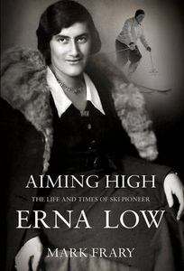
£18.99
Topographic survey of France at 1:25, 000 in IGN`s excellent TOP25 / Série Bleue series. All the maps are GPS compatible, with a 1km UTM grid plus latitude & longitude lines at 5’ intervals. Contours are at 5m intervals except for mountainous areas where the maps have contours at 10m intervals, vividly enhanced by hill shading & graphics for rocky terrain. Colouring with graphics indicates different types of vegetation or land use (deciduous or coniferous forests, moors, orchards, vineyards, etc). PLEASE NOTE: coverage of France at this scale is currently being revised – the format & the presentation of each title are indicated by the letters at the end of its Sheet Reference number (e.g. 0416ET, 3531ETR, 1923SB, etc.)MAPS WITH FULL TOURIST OVERPRINT & AN ENGLISH MAP LEGEND: all TOP25 maps & the SB editions of Série Bleue have an overprint highlighting waymarked walking trails including long-distance GR routes &, where appropriate, ski routes. Symbols indicate campsites, gîtes d’etape, refuges, equestrian centres & other recreational facilities or sites, tourist information centres, cultural heritage, etc. Towns & locations of particular interest are highlighted.- ET or OT = single-sided TOP25 map covering approx. 29x 21 km / 18x 13 miles.- ETR or OTR = waterproof & tear resistant TOP25 map covering the same area as the corresponding ET or OT number, but double-sided, printed on a smaller size sheet with a good overlap between the sides.- SB = Série Bleue map with full tourist overprint; these maps, first introduced in summer 2014, each cover approx. 29x 24km / 18x 15 miles.SÉRIE BLEUE maps with numbers ending in E (Est) or O (Ouest): most editions now indicate the GR routes, but do not show any other tourist information. Map legend is in French only. Each map covers approx. 14x 20km / 9x 12 miles. ...
Archived Product
£12.99
Topographic survey of France at 1:25, 000 in IGN`s excellent TOP25 / Série Bleue series. All the maps are GPS compatible, with a 1km UTM grid plus latitude & longitude lines at 5’ intervals. Contours are at 5m intervals except for mountainous areas where the maps have contours at 10m intervals, vividly enhanced by hill shading & graphics for rocky terrain. Colouring with graphics indicates different types of vegetation or land use (deciduous or coniferous forests, moors, orchards, vineyards, etc). PLEASE NOTE: coverage of France at this scale is currently being revised – the format & the presentation of each title are indicated by the letters at the end of its Sheet Reference number (e.g. 0416ET, 3531ETR, 1923SB, etc.)MAPS WITH FULL TOURIST OVERPRINT & AN ENGLISH MAP LEGEND: all TOP25 maps & the SB editions of Série Bleue have an overprint highlighting waymarked walking trails including long-distance GR routes &, where appropriate, ski routes. Symbols indicate campsites, gîtes d’etape, refuges, equestrian centres & other recreational facilities or sites, tourist information centres, cultural heritage, etc. Towns & locations of particular interest are highlighted.- ET or OT = single-sided TOP25 map covering approx. 29x 21 km / 18x 13 miles.- ETR or OTR = waterproof & tear resistant TOP25 map covering the same area as the corresponding ET or OT number, but double-sided, printed on a smaller size sheet with a good overlap between the sides.- SB = Série Bleue map with full tourist overprint; these maps, first introduced in summer 2014, each cover approx. 29x 24km / 18x 15 miles.SÉRIE BLEUE maps with numbers ending in E (Est) or O (Ouest): most editions now indicate the GR routes, but do not show any other tourist information. Map legend is in French only. Each map covers approx. 14x 20km / 9x 12 miles. ...
Archived Product
£18.99
Topographic survey of France at 1:25, 000 in IGN`s excellent TOP25 / Série Bleue series. All the maps are GPS compatible, with a 1km UTM grid plus latitude & longitude lines at 5’ intervals. Contours are at 5m intervals except for mountainous areas where the maps have contours at 10m intervals, vividly enhanced by hill shading & graphics for rocky terrain. Colouring with graphics indicates different types of vegetation or land use (deciduous or coniferous forests, moors, orchards, vineyards, etc). PLEASE NOTE: coverage of France at this scale is currently being revised – the format & the presentation of each title are indicated by the letters at the end of its Sheet Reference number (e.g. 0416ET, 3531ETR, 1923SB, etc.)MAPS WITH FULL TOURIST OVERPRINT & AN ENGLISH MAP LEGEND: all TOP25 maps & the SB editions of Série Bleue have an overprint highlighting waymarked walking trails including long-distance GR routes &, where appropriate, ski routes. Symbols indicate campsites, gîtes d’etape, refuges, equestrian centres & other recreational facilities or sites, tourist information centres, cultural heritage, etc. Towns & locations of particular interest are highlighted.- ET or OT = single-sided TOP25 map covering approx. 29x 21 km / 18x 13 miles.- ETR or OTR = waterproof & tear resistant TOP25 map covering the same area as the corresponding ET or OT number, but double-sided, printed on a smaller size sheet with a good overlap between the sides.- SB = Série Bleue map with full tourist overprint; these maps, first introduced in summer 2014, each cover approx. 29x 24km / 18x 15 miles.SÉRIE BLEUE maps with numbers ending in E (Est) or O (Ouest): most editions now indicate the GR routes, but do not show any other tourist information. Map legend is in French only. Each map covers approx. 14x 20km / 9x 12 miles. ...
Archived Product
£11.50
Topographic survey of France at 1:25, 000 in IGN`s excellent TOP25 / Série Bleue series. All the maps are GPS compatible, with a 1km UTM grid plus latitude & longitude lines at 5’ intervals. Contours are at 5m intervals except for mountainous areas where the maps have contours at 10m intervals, vividly enhanced by hill shading & graphics for rocky terrain. Colouring with graphics indicates different types of vegetation or land use (deciduous or coniferous forests, moors, orchards, vineyards, etc). PLEASE NOTE: coverage of France at this scale is currently being revised – the format & the presentation of each title are indicated by the letters at the end of its Sheet Reference number (e.g. 0416ET, 3531ETR, 1923SB, etc.)MAPS WITH FULL TOURIST OVERPRINT & AN ENGLISH MAP LEGEND: all TOP25 maps & the SB editions of Série Bleue have an overprint highlighting waymarked walking trails including long-distance GR routes &, where appropriate, ski routes. Symbols indicate campsites, gîtes d’etape, refuges, equestrian centres & other recreational facilities or sites, tourist information centres, cultural heritage, etc. Towns & locations of particular interest are highlighted.- ET or OT = single-sided TOP25 map covering approx. 29x 21 km / 18x 13 miles.- ETR or OTR = waterproof & tear resistant TOP25 map covering the same area as the corresponding ET or OT number, but double-sided, printed on a smaller size sheet with a good overlap between the sides.- SB = Série Bleue map with full tourist overprint; these maps, first introduced in summer 2014, each cover approx. 29x 24km / 18x 15 miles.SÉRIE BLEUE maps with numbers ending in E (Est) or O (Ouest): most editions now indicate the GR routes, but do not show any other tourist information. Map legend is in French only. Each map covers approx. 14x 20km / 9x 12 miles. ...
Archived Product
£9.99
Part of a series of exciting & luxurious Flame Tree Notebooks. Combining high-quality production with magnificent fine art, ...
Archived Product
£5.99
The départments of Ain & Haute-Savoie in the French Alps at 1:150, 000 in Michelin’s Local Series, with highlighting for scenic routes, an index, a special panel with best sights & recommended driving tours, & street plans of Annecy & Bourg-en-Bresse. Coverage extends from the Saône & the Rhône to the border, including the whole of Lake Geneva & Courmayeur on the Italian side of Mont Blanc. Numerous popular holiday destinations are covered, including Chamonix, St-Gervais-les-Bains, Megève, La Cluzas, Annecy, Albertville, Aix-les-Bains, Samoëns, Morzine, Evian-les-Bains, etc, as well as the highest part of the French Jura. PLEASE NOTE: our coverage image, provided by the publishers, does not take into account which areas along the edge of the map are blocked by the index & the additional features – the south-eastern corner with the Vanoise National Park is not included. Maps in Michelin’s Local Series of France have the same cartography (road network & place names shown on the maps) as the publishers’ Regional Series at 1;200, 000 but enlarged here to 1:150, 000 to provide greater clarity & larger, easier to read print size. Road network is presented in great detail, indicating width, motorway services & rest areas, dangerous or restricted entry roads, steep gradients, height & weight restrictions, etc. Scenic sections are highlighted. The maps also show selected cycle paths & nature trails. Railway lines are shown with stations & local airports are marked. Symbols indicate various places of interest, with additional star rating for best sights, based on the publishers’ Green Guides for French regions. Satellite-derived base with colouring for the forested areas & boundaries of national or regional parks shows the topography. In the mountainous regions the maps have bold, very effective relief shading, with a large number of names of peaks, passes, & other topographic features. The maps have latitude & longitude lines at 10’ intervals & are indexed. Map legend

Includes::
English. Each title in addition

Includes::
a panel showing the area’s principal roads & places of interest, plus recommendations for sightseeing tours. Also provided are town centre maps of main cities, indicating principal traffic arteries, one way streets & places of interest. Only selected streets are named & listed in the accompanying index. Please click on the series link to see all the titles in this series.


...
Archived Product
£2.95
Ainsworth in 1908 in a fascinating series of reproductions of old Ordnance Survey plans in the Alan Godfrey Editions, ideal for anyone interested in the history of their neighbourhood or family. Selected towns in Great Britain & Ireland are covered by maps showing the extent of urban development in the last decades of the 19th & early 20th century. In this title: the map covers the village of Ainsworth, midway between Bolton & Bury. Features include Christ Church, Hey Club Row, chapels, Moorside Mill, quarry, Ainsworth Hall, Anthony Fields, Ainsworth Hospital, & various outlying houses. Coverage extends eastward to Cockey Moor & westward to Breightmet Fold (in the south-westrn corner of map) on the outskirts of Bolton; features there include Breightmet Bleach Works, Red Bridge Mill. Harwood Lodge is in north-west corner of map. On the reverse is a directory of Ainsworth, plus portraits & information on John Miles, Mayor of Bolton, & John Battersby, Mayor of Bury, & their wives. About the Alan Godfrey Editions of the 25 ...
Archived Product
£3.50
Ainsworth in 1908 in a fascinating series of reproductions of old Ordnance Survey plans in the Alan Godfrey Editions, ideal for anyone interested in the history of their neighbourhood or family. The map covers the village of Ainsworth, midway between Bolton & Bury. Features include Christ Church, Hey Club Row, chapels, Moorside Mill, quarry, Ainsworth Hall, Anthony Fields, Ainsworth Hospital & various outlying houses. Coverage extends eastward to Cockey Moor & westward to Breightmet Fold (in the south-westrn corner of map) on the outskirts of Bolton; features there include Breightmet Bleach Works, Red Bridge Mill. Harwood Lodge is in north-west corner of map. On the reverse is a directory of Ainsworth, plus portraits & information on John Miles, Mayor of Bolton, & John Battersby, Mayor of Bury, & their wives. About the Alan Godfrey Editions of the 25” OS Series: Selected towns in Great Britain & Ireland are covered by maps showing the extent of urban development in the last decades of the 19th & early 20th century. The plans have been taken from the Ordnance Survey mapping & reprinted at about 15 inches to one mile (1:4, 340). On the reverse most maps have historical notes & many also include extracts from contemporary directories. Most maps cover about one mile (1.6kms) north/south, one & a half miles (2.4kms) across; adjoining sheets can be combined to provide wider coverage.FOR MORE INFORMATION & A COMPLETE LIST OF ALL AVAILABLE TITLES PLEASE CLICK ON THE SERIES LINK. ...
Archived Product
£3.50
Aintree in 1906 in a fascinating series of reproductions of old Ordnance Survey plans in the Alan Godfrey Editions, ideal for anyone interested in the history of their neighbourhood or family. The map covers much of Aintree, north of Liverpool, & is dominated by the famous racecourse. Coverage stretches from Warbreck Moor eastward to Moss Pits Lane, & northward to Aintree House. Features include Aintree Racecourse with Grandst&, Greenwich Park Athletic Ground, much of City Hospital, Kirkdale Cemetery, stretch of Cheshire Lines Railway with Aintree station; stretch of LYR Liverpool-Accrington line with Aintree station, Aintree North Curve, engine shed, Fazakerley & North Mersey Branch, Race Course station, carriage & wagon works, signal works, Liverpool & Bolton line, Fazakerley station; St Peter`s church, tramways, short stretch of Leeds & Liverpool Canal, Moss Pits, Greenwich House, Stag Farm, Sefton Arms Hotel, Melling Road, etc. On the reverse is a selection of street directory entries, including Aintree Village, Eastbourne Road, Fifth Avenue, Greenwich Road, Helsby Road, Hooton Road, Kingswood Avenue, Longmoor Lane, Melling Avenue, Melling Road, Warbreck Moor & Wyresdale Road. About the Alan Godfrey Editions of the 25” OS Series: Selected towns in Great Britain & Ireland are covered by maps showing the extent of urban development in the last decades of the 19th & early 20th century. The plans have been taken from the Ordnance Survey mapping & reprinted at about 15 inches to one mile (1:4, 340). On the reverse most maps have historical notes & many also include extracts from contemporary directories. Most maps cover about one mile (1.6kms) north/south, one & a half miles (2.4kms) across; adjoining sheets can be combined to provide wider coverage.FOR MORE INFORMATION & A COMPLETE LIST OF ALL AVAILABLE TITLES PLEASE CLICK ON THE SERIES LINK. ...
Archived Product
£13.00
Fold realistic paper models of some of the most astonishing aircraft & spacecraft ever designed! The Smithsonian`s National Air & Space Museum hosts seven million visitors annually; a testament to our enduring fascination with flight. Noted origami artist John Szinger has created this unique collection of 14 paper models inspired by real-life flying vehicles; from commercial jetliners to single- & multi-stage rockets, a re-entry space pod & even a UFO! Each model comes complete with a set of interesting facts about the vehicle as well as detailed step-by-step instructions showing you how to fold it. This box contains everything you need: a full-colour instruction book, 48 sheets of high-quality folding paper plus over 100 stickers to add the finishing details. Let your imagination soar with 14 original designs, including: A Supersonic Transport recalling the golden age of commercial hypersonic travel! The Space Pod, designed to safely return astronauts to earth through the intense heat of re-entry! A graceful Hot Air Balloon;make several to create your own miniature ballooning festival! An elusive Flying Saucer;try as they might, the government can`t conceal this one! A sci-fi inspired Art Deco Rocket with exaggerated fins & sleek lines! & many other thrilling origami air & space models! This kit
Includes:: A colourful 64-page step-by-step origami instructions book 14 exciting air & space origami projects 48 sheets of double-sided, custom designed folding paper 100+ colourful Stickers
...
Archived Product

Aiming High

Erna Low, born in Vienna in 1909, was instrumental in starting what has become a multimillion pound industry: the ski holiday business. In 1932, she placed an advert in the Morning Post saying ”Austria, fortnight, GBP15 only, including rail and hotel, arranged by young Viennese Graduette for young people leaving Christmas”. For her, it was a way to get back home to see her family over Christmas, but the popularity of the trip soon saw it develop into a lucrative business. Erna, an Austrian javelin champion and handball player, soon branched out into parties for the young elite at country houses around Britain, becoming something of a matchmaker for the 20- and 30-somethings who flocked to her events year after year. When war came to Europe, she joined the BBC, listening
in on German broadcasts to help the Allied effort. After normality had been restored, she grasped the opportunity offered by rising standards of living and grew her eponymous company into a leading travel company in the market by the 1960s, introducing many holiday destinations and concepts to the British market.A consummate networker, Erna Low introduced herself to the great and the good and became their friend and confidante. She taught royalty, actors and politicians to ski. This illustrated hardback biography examines Erna`s life, including interviews with her friends and colleagues and shows how her strength of character and business nous enabled her to succeed in a male-dominated world. It will appeal to anyone interested in the history of skiing and travel in Britain, the
hundreds of thousands of past and present customers of Erna Low as well as anyone interested in how an independent young Austrian woman from a challenging background became a household name and business success in Britain. A foreword has been written by Roger Lloyd Pack. ”2012 is the 80th anniversary of the first Erna Low-organised ski trip. The current chief executive of her company has an amazing archive of material collected by Erna during her life and it was going through this that inspired me to write it, ” says author Mark about Aiming High.
RIP - This product is no longer available on our network. It was last seen on 25.09.2019

This page now acts as a permanent archive for this product. Add more information using the comments box below to ensure it can still be found by future generations.

Use our search facility to see if it is available from an alternative contributor.
  • External links may include paid for promotion
  • Availability: Out Of Stock
  • Supplier: Stanfords
  • SKU: 9781780883540
Availability: In Stock
£19.95

Product Description

Erna Low, born in Vienna in 1909, was instrumental in starting what has become a multimillion pound industry: the ski holiday business. In 1932, she placed an advert in the Morning Post saying ” Austria, fortnight, GBP15 only, including rail & hotel, arranged by young Viennese Graduette for young people leaving Christmas”. For her, it was a way to get back home to see her family over Christmas, but the popularity of the trip soon saw it develop into a lucrative business. Erna, an Austrian javelin champion & handball player, soon branched out into parties for the young elite at country houses around Britain, becoming something of a matchmaker for the 20- & 30-somethings who flocked to her events year after year. When war came to Europe, she joined the BBC, listening in on German broadcasts to help the Allied effort. After normality had been restored, she grasped the opportunity offered by rising standards of living & grew her eponymous company into a leading travel company in the market by the 1960s, introducing many holiday destinations & concepts to the British market.A consummate networker, Erna Low introduced herself to the great & the good & became their friend & confidante. She taught royalty, actors & politicians to ski. This illustrated hardback biography examines Erna`s life, including interviews with her friends & colleagues & shows how her strength of character & business nous enabled her to succeed in a male-dominated world. It will appeal to anyone interested in the history of skiing & travel in Britain, the hundreds of thousands of past & present customers of Erna Low as well as anyone interested in how an independent young Austrian woman from a challenging background became a household name & business success in Britain. A foreword has been written by Roger Lloyd Pack. ”2012 is the 80th anniversary of the first Erna Low-organised ski trip. The current chief executive of her company has an amazing archive of material collected by Erna during her life & it was going through this that inspired me to write it, ” says author Mark about Aiming High.

Reviews/Comments

Add New

Intelligent Comparison

Oooops!
We couldn't find anything!
Perhaps this product's unique.... Or perhaps we are still looking for comparisons!
Click to bump this page and we'll hurry up.

Price History

Vouchers

No voucher codes found.
Do you know a voucher code for this product or supplier? Add it to Insights for others to use.

Facebook

Jargon Buster

Hotel - An establishment which provides lodging for a fee
Friends - A close associate or a popular US based sitcom about a group of friends
History - Anything that happens in the past. An acedemic subject.
Parties - A gathering of people to celebrate and event or occasion
World - A physical grouping, commonly used to describe earth and everything associated with ti
Year - The time it takes the planet earth to orbit the sun. This takes around 365.25 days.
Hardback - Referring to books something that is made from thick stiff card
Home - A place of permanent residence for families.
Year - 365 days (366 days in a leap year), the time taken for planet earth to make one full revolution around the sun.
Family - A group of people that live together made up from parents and children.

Supplier Information

Stanfords
Stanfords was established in 1853 and opened their iconic Covent Garden flagship store in 1901. They have become the top retailer of maps, travel books and accessories in the UK and arguably offer the largest selection of maps and travel books worldwide. Famous names such as Captain Robert Falcon Scott, Ranulph Fiennes and Michael Palin have purchased from Stanfords. They now have a shop in Bristol and both stores together with other venues operate a calendar of events including talks, book signings and exhibitions. As a specialist map retailer, the map selection is comprehensive and includes road maps, street maps and walking maps from worldwide destinations, as well as a selection of world atlases and wall maps. Books include travel guides and travel literature. Stanfords also stock globes, from miniatures made of blue marble to magnificent floor-standing globes. The website features a selection of interesting articles on travel topics.
Page Updated: 2023-11-12 20:15:36

Community Generated Product Tags

Oh No! The productWIKI community hasn't generated any tags for this product yet!
Menu