More From Contributor
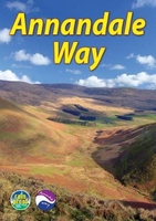
£10.99
TRANSLATED BY LOUISE & AYLMER MAUDE. Anna is a beautiful, intelligent woman whose passionate affair with the dashing Count Vronsky leads her to ruin. But her story is also about a search for meaning, & by twinning it with that of Levin, an awkward idealist whose happy marriage & domestic trials form the backdrop for a similar quest, Tolstoy creates a rich & complex masterpiece that has captured the imagination of readers for decades. The Vintage Classic Russians Series: Published for the 100th anniversary of the 1917 Russian Revolution, these are must-have, beautifully designed editions of six epic masterpieces that have survived controversy, censorship & suppression to influence decades of thought & artistic expression. ...
Archived Product
£6.99
Anna Liza likes to help cheer up her mother`s psychiatric patients with her 17 top knock-knock jokes & cheerful songs, but when she meets Edward, she hits a brick wall. Edward`s dad is so sad since his mum left; he says his life isn`t going anywhere any more. Anna Liza has a plan to get him on the move again, if only she can manage to evade her mother`s attention long enough. High quality cream paper & a special easy to read font ensure a smooth read for all. ...
Archived Product
£12.99
Features over 50 recipes from London`s legendary Mac N Cheese truck. This book is full of pimped up mac `n` cheese recipes, things to do with leftovers (mac `n` cheese fries anyone?) plus tips on how to make the best bechamel sauce, the perfect cheeses to use, as well as recipes for sides, sauces, drinks & desserts to serve alongside. Featuring recipes for some of their well-known classics such as the Don Macaroni with bacon & pesto to the chipotle-laced Spicy Juan; to experimental ideas for the serious Macologist, including Machos, alpine-inspired Maclette, Mac-Packed Peppers, Mac `n` Cheese Fries, the ultimate grilled cheese sandwich & more. Not forgetting the perfect wingmen to accompany your mac
- they`ve got pickles, guac`, kwik kimchi, salads & sauces as well as festival cocktails & hangover cures covering all the bases. ” Best Mac `n` Cheese this side of the Atlantic.” (Elle). ” Worth getting messy for.” (Metro).
...
Archived Product
£2.50
Annan street map from Nicolson Maps; coverage

Includes::
Eastriggs, Gretna & Longtown. Nicolson Maps, Scotland’s

...
Archived Product
£3.50
Annan in 1898 in a fascinating series of reproductions of old Ordnance Survey plans in the Alan Godfrey Editions, ideal for anyone interested in the history of their neighbourhood or family. Coverage stretches from Howes eastward to Watchhill, & from Annan station northward to Gala Bank. Features include the town centre, High Street area, banks, hotels, churches, stretch of GSWR railway with station & goods yard, stretch of CR railway with station, infectious diseases hospital, Milnfield, River Annan, Ever Holm, Silverwalk, Solway Place, Provost Mills, violetbank, Fish Cross, Newington Lodge, auction mart, etc. On the reverse are extracts from a trade directory. About the Alan Godfrey Editions of the 25” OS Series: Selected towns in Great Britain & Ireland are covered by maps showing the extent of urban development in the last decades of the 19th & early 20th century. The plans have been taken from the Ordnance Survey mapping & reprinted at about 15 inches to one mile (1:4, 340). On the reverse most maps have historical notes & many also include extracts from contemporary directories. Most maps cover about one mile (1.6kms) north/south, one & a half miles (2.4kms) across; adjoining sheets can be combined to provide wider coverage.FOR MORE INFORMATION & A COMPLETE LIST OF ALL AVAILABLE TITLES PLEASE CLICK ON THE SERIES LINK. ...
Archived Product
£6.39
A detailed topographic map of Annandale from the Ordnance Survey Explorer series, covering Annan, Lockerbie & Beattock. Edition A1; Publication date August 2006 About this series: These highly detailed maps show all the administrative boundaries, settlements as small as isolated farms, the road network down to unfenced roads & country tracks, & field boundaries (hedges & drystone walls) which make navigation across the countryside much easier. Steep gradients on roads are indicated. Various landmarks, e.g. powerlines, archaeological sites, windmills, churches & lighthouses are shown & additional graphics indicate natural terrain features such as cliffs, scree, mud & vegetation variations. The contour interval is 5 metres in the lower parts of the country & 10 metres in the uplands, & spot heights are marked. Each map covers an area of 30 x 20km (i.e. approx. 19 x 12 miles), with some double-sided maps covering more, as indicated in the individual descriptions. The maps are fully GPS compatible, with the National Grid shown at 1km intervals & latitude & longitude indicated by margin ticks at 1'. The Explorer series has replaced the earlier, green-cover Pathfinder maps. The Explorer series is now complete & covers all of Engl&, Wales & Scotl&. Some sheets for popular areas like the National Parks are still branded as Outdoor Leisure (OL) maps, but are now included in this series as the cartography is the same as that in the Explorer Maps. The Explorer maps offer a substantial improvement on the Pathfinder series, with greater use of colour, larger area per map, & stronger emphasis on information for ramblers & tourists. This series is ideal for walking & other outdoor pursuits & each map shows a large amount of information for ramblers & tourists. Public rights of way are shown (except in Scotland), together with other routes with public access: National Trails & Recreational Paths, permitted paths & bridleways, & selected cycle routes. Open access land created under the Countryside & Rights of Way Act 2000 is marked. Tourist information

Includes::
caravan & camp sites, Park & Ride locations, recreation/leisure/sport centres, museums, historic buildings, English Heritage & National Trust sites, rural pubs, etc. The map legend is in English only, except for the tourist information content which is also in French & German.

...
Archived Product
£11.19
Laminated waterproof edition of a detailed topographic map of Annandale from the Ordnance Survey Explorer series, covering Annan, Lockerbie & Beattock. Edition A1; Publication date November 2006 About this series: These highly detailed maps show all the administrative boundaries, settlements as small as isolated farms, the road network down to unfenced roads & country tracks, & field boundaries (hedges & drystone walls) which make navigation across the countryside much easier. Steep gradients on roads are indicated. Various landmarks, e.g. powerlines, archaeological sites, windmills, churches & lighthouses are shown & additional graphics indicate natural terrain features such as cliffs, scree, mud & vegetation variations. The contour interval is 5 metres in the lower parts of the country & 10 metres in the uplands, & spot heights are marked. Each map covers an area of 30 x 20km (i.e. approx. 19 x 12 miles), with some double-sided maps covering more, as indicated in the individual descriptions. The maps are fully GPS compatible, with the National Grid shown at 1km intervals & latitude & longitude indicated by margin ticks at 1'. The Explorer series has replaced the earlier, green-cover Pathfinder maps. The Explorer series is now complete & covers all of Engl&, Wales & Scotl&. Some sheets for popular areas like the National Parks are still branded as Outdoor Leisure (OL) maps, but are now included in this series as the cartography is the same as that in the Explorer Maps. The Explorer maps offer a substantial improvement on the Pathfinder series, with greater use of colour, larger area per map, & stronger emphasis on information for ramblers & tourists. This series is ideal for walking & other outdoor pursuits & each map shows a large amount of information for ramblers & tourists. Public rights of way are shown (except in Scotland), together with other routes with public access: National Trails & Recreational Paths, permitted paths & bridleways, & selected cycle routes. Open access land created under the Countryside & Rights of Way Act 2000 is marked. Tourist information

Includes::
caravan & camp sites, Park & Ride locations, recreation/leisure/sport centres, museums, historic buildings, English Heritage & National Trust sites, rural pubs, etc. The map legend is in English only, except for the tourist information content which is also in French & German.

...
Archived Product
£14.99
Annandale, Annan, Lockerbie & Beattock area on a detailed topographic & GPS compatible map No. 322, waterproof version, from the Ordnance Survey’s 1:25, 000 Explorer series. MOBILE DOWNLOADS: this title & all the other OS Explorer maps include a code for downloading after purchase the digital version onto your smartphone or tablet for viewing on the OS smartphone app.OS EXPLORER SERIES: to see the list of all the titles in the OS Explorer series, both paper & waterproof versions, please click on the series link. The Explorer series, Ordnance Survey’s most detailed maps recommended for anyone enjoying outdoor activities, provides topographic coverage of Great Britain at 1:25, 000 on GPS compatible maps with hiking trails, cycling routes & extensive tourist information. Each printed map is available either on paper or as a waterproof & tear-resistant OS Active Map, as indicated in its title. Britain’s National Parks & other areas of particular tourist interest are presented on often double-sided OL (Outdoor Leisure) maps, whilst most standard format Explorers cover an area of 30 x 20km (approx. 19 x 12 miles). All three versions (paper, waterproof & digital) are the same & provide plenty of recreational & tourist information, indicating the traditional public right of way paths (except in Scotland where different laws apply), including bridleways & byways. National Trails & other long-distance paths are marked, as well as permissive footpaths or bridleways & on-road or traffic-free cycle routes with, where appropriate, their National/ Regional Cycle Network numbers. Boundaries of access land are clearly marked. A wide range of symbols provides additional tourist information, highlighting camping & caravanning sites, information offices & visitors’ centres, parking & picnicking places, country pubs, sport & recreational facilities including cycle hire locations & mountain biking trails, historic buildings & museums, etc. Exceptionally clear presentation of the landscape is provided by contours at 5m or in the uplands at 10m intervals, with additional spot heights plus colouring and/or graphics for different types of woodlands, orchards, heath, marshl&, scree or boulders, & other topographic features. For GPS users the maps have British National Grid lines at 1km intervals, with latitude & longitude given by margin ticks at 1`. Clearly laid out map legend

Includes::
French & German translations for the tourist information symbols.

...
Archived Product
£8.99
Annandale, Annan, Lockerbie & Beattock area on a detailed topographic & GPS compatible map No. 322, paper version, from the Ordnance Survey’s 1:25, 000 Explorer series.MOBILE DOWNLOADS: this title & all the other OS Explorer maps include a code for downloading after purchase the digital version onto your smartphone or tablet for viewing on the OS smartphone app.OS EXPLORER SERIES: to see the list of all the titles in the OS Explorer series, both paper & waterproof versions, please click on the series link. The Explorer series, Ordnance Survey’s most detailed maps recommended for anyone enjoying outdoor activities, provides topographic coverage of Great Britain at 1:25, 000 on GPS compatible maps with hiking trails, cycling routes & extensive tourist information. Each printed map is available either on paper or as a waterproof & tear-resistant OS Active Map, as indicated in its title. Britain’s National Parks & other areas of particular tourist interest are presented on often double-sided OL (Outdoor Leisure) maps, whilst most standard format Explorers cover an area of 30 x 20km (approx. 19 x 12 miles). All three versions (paper, waterproof & digital) are the same & provide plenty of recreational & tourist information, indicating the traditional public right of way paths (except in Scotland where different laws apply), including bridleways & byways. National Trails & other long-distance paths are marked, as well as permissive footpaths or bridleways & on-road or traffic-free cycle routes with, where appropriate, their National/ Regional Cycle Network numbers. Boundaries of access land are clearly marked. A wide range of symbols provides additional tourist information, highlighting camping & caravanning sites, information offices & visitors’ centres, parking & picnicking places, country pubs, sport & recreational facilities including cycle hire locations & mountain biking trails, historic buildings & museums, etc. Exceptionally clear presentation of the landscape is provided by contours at 5m or in the uplands at 10m intervals, with additional spot heights plus colouring and/or graphics for different types of woodlands, orchards, heath, marshl&, scree or boulders, & other topographic features. For GPS users the maps have British National Grid lines at 1km intervals, with latitude & longitude given by margin ticks at 1`. Clearly laid out map legend

Includes::
French & German translations for the tourist information symbols.

...
Archived Product
£12.99
Annapurna region at 1:100, 000 in a series of detailed topographic maps of selected trekking areas of Nepal originally prepared by E. Schneider & now edited by the German Scientific Association of Comparative High-Mountain Research (Arbeitsgemeinschaft für vergleichende Hochgebirgsforschung). The map covers the whole of the Annapurna Circuit, extending from Pokhara to Muktinath & Jomosom. Contours are at 100m intervals. An overprint highlights the route of the Annapurna Circuit, but no other tourist information is provided. The map has 10-km UTM crosshairs, plus margin ticks for latitude & longitude at 15’. Map legend is in English. Current edition of this map was published in 2005. Traditionally referred to as “the Schneider maps”, titles in this series cover Nepal’s most popular trekking regions at 1:50, 000 or 1:100, 000. The maps were originally prepared by the Austrian climber & cartographer Erwin Schneider & for nearly five decades provided the best & often the only coverage of these areas. Now sponsored by the German Scientific Association of Comparative High-Mountain Research (Arbeitsgemeinschaft für vergleichende Hochgebirgsforschung), the maps are still"ed in most trekking guides to Nepal. Most maps have contours at 40-m intervals &, with bold relief shading & colouring for the glaciers, provide a vivid representation of the terrain. As the series is currently being revised to include more trekking information, please see the individual descriptions for more details. Please click on the series link to see the full list of currently available titles. ...
Archived Product

Annandale Way

The Annandale Way is a charming long walk in a little-known, but very accessible, part of southern Scotland. Walked southward from source to the sea, it starts in the sheep town of Moffat, and runs for 56 miles (90 km) via Lochmaben, with superb views from the top of Almagill Hill. A slightly shorter branch of the route goes via Lockerbie and Eskrigg Nature Reserve. The two branches rejoin north of Annan to reach the Solway Firth at Newbiebarns. This guidebook contains everything you need to plan and enjoy your trip: detailed route description for walking from north to south foreword by broadcaster Stephen Jardine background on the history and economy of Annandale seven pages of habitats and wildlife with superb images planning information for transport and accommodation seven pages
of detailed mapping of the route at 1:44, 000 summary of each section showing distance, terrain and food/drink stops concise directions for those who prefer to walk south to north lavishly illustrated, with over 100 colour photographs rucksack-friendly format, printed on rainproof paper.
RIP - This product is no longer available on our network. It was last seen on 25.09.2019

This page now acts as a permanent archive for this product. Add more information using the comments box below to ensure it can still be found by future generations.

Use our search facility to see if it is available from an alternative contributor.
  • External links may include paid for promotion
  • Availability: Out Of Stock
  • Supplier: Stanfords
  • SKU: 9781898481751
Availability: In Stock
£12.99

Product Description

The Annandale Way is a charming long walk in a little-known, but very accessible, part of southern Scotl&. Walked southward from source to the sea, it starts in the sheep town of Moffat, & runs for 56 miles (90 km) via Lochmaben, with superb views from the top of Almagill Hill. A slightly shorter branch of the route goes via Lockerbie & Eskrigg Nature Reserve. The two branches rejoin north of Annan to reach the Solway Firth at Newbiebarns. This guidebook contains everything you need to plan & enjoy your trip: detailed route description for walking from north to south foreword by broadcaster Stephen Jardine background on the history & economy of Annandale seven pages of habitats & wildlife with superb images planning information for transport & accommodation seven pages of detailed mapping of the route at 1:44, 000 summary of each section showing distance, terrain & food/drink stops concise directions for those who prefer to walk south to north lavishly illustrated, with over 100 colour photographs rucksack-friendly format, printed on rainproof paper.

Reviews/Comments

Add New

Intelligent Comparison

Oooops!
We couldn't find anything!
Perhaps this product's unique.... Or perhaps we are still looking for comparisons!
Click to bump this page and we'll hurry up.

Price History

Vouchers

No voucher codes found.
Do you know a voucher code for this product or supplier? Add it to Insights for others to use.

Facebook

Jargon Buster

Paper - A thin sheet mainly used for writing. Available in a variety of colours. Made mainly from wood pulp.
History - Anything that happens in the past. An acedemic subject.
Colour - The categorised spectrum of light visable to humans
Km - Kilometre. A unit of measurement equal to 1000 metres.
Rucksack - A bag which is carried on the back.
Accommodation - A room in which someone can live in, for example in a hotel
Transport - Something that carries people or goods.

Supplier Information

Stanfords
Stanfords was established in 1853 and opened their iconic Covent Garden flagship store in 1901. They have become the top retailer of maps, travel books and accessories in the UK and arguably offer the largest selection of maps and travel books worldwide. Famous names such as Captain Robert Falcon Scott, Ranulph Fiennes and Michael Palin have purchased from Stanfords. They now have a shop in Bristol and both stores together with other venues operate a calendar of events including talks, book signings and exhibitions. As a specialist map retailer, the map selection is comprehensive and includes road maps, street maps and walking maps from worldwide destinations, as well as a selection of world atlases and wall maps. Books include travel guides and travel literature. Stanfords also stock globes, from miniatures made of blue marble to magnificent floor-standing globes. The website features a selection of interesting articles on travel topics.
Page Updated: 2023-11-12 20:15:36

Community Generated Product Tags

Oh No! The productWIKI community hasn't generated any tags for this product yet!
Menu