More From Contributor

£8.99
Half-brothers Michel & Bruno have a mother in common but little else. Michel is a molecular biologist, a thinker & idealist, a man with no erotic life to speak of & little in the way of human society. Bruno, by contrast, is a libertine, though more in theory than in practice, his endless lust is all too rarely reciprocated. Both are symptomatic members of our atomised society, where religion has given way to shallow `new age` philosophies & love to meaningless sexual connections. Atomised (Les Particules elementaires) tells the stories of the two brothers, but the real subject of the novel is the dismantling of contemporary society & its assumptions, its political incorrectness, & its caustic & penetrating asides on everything from anthropology to the problem pages of girls` magazines. A dissection of modern lives & loves. By turns funny, acid, infuriating, didactic, touching & visceral. ...
Archived Product
£9.99
Ian Mc Ewan`s haunting tale unfolds on the hottest day of the English summer of 1934. Thirteen-year-old Briony Tallis sees her sister Cecilia strip off her clothes & plunge into the fountain in the garden of their country house. Watching her is Robbie Turner, her childhood friend who, like Cecilia, has recently come down from Cambridge. By the end of that day, the lives of all three will have been changed for ever. Robbie & Cecilia will have crossed a boundary they had not even imagined at its start, & will have become victims of the younger girl`s imagination. Briony will have witnessed mysteries, & committed a crime for which she will spend the rest of her life trying to atone. Shortlisted for the 2001 Booker Prize, Mc Ewan has produced a landmark work in his oeuvre that also shows, quite literally as the crux of the books story, the power of just one word & the dangers of miscommunication. ...
Archived Product
£9.99
In Attention All Shipping, Charlie Connelly looks at the Shipping Forecast, which, regularly broadcast on BBC radio, is for many a familiar & reassuring element of the British cultural landscape. Its content could spell the difference between life & death for seafarers, but arguably less so for audiences in the garden shed or suburban living room. Here the author wittily sheds some light on the places behind the names, & their historical & odd cultural associations. The weather gets a mention here & there too. ...
Archived Product
£14.99
Rising star Joshua Cohen`s first collection of essays, a fully realized work created from a selection of previously published & new nonfiction
- essays, memoir, criticism, letters, diaries
- covering an extraordinary array of topics: politics, literature, art, music, travel, the media, & psychology, on subjects ranging from Donald Trump, Bernie Sanders, animals in literature, Gustav Mahler, Aretha Franklin, Edward Snowden, Gordon Lish, the closing of the Ringling Bros. circus, Google, Thomas Pynchon, & Azerbaijan. In thirty essays & forty short `interludes`, Cohen directs his sharp gaze out upon the world, exhibiting his deep erudition & ability to draw connections between seemingly unlike things, showing us how to look at a world overflowing with information without becoming daunted. In each piece, Cohen projects a quality of thought that is uniquely his, & a voice as witty, powerful, funny, & distinct as any in American letters.

...
Archived Product
£3.50
Attercliffe in 1903 in a fascinating series of reproductions of old Ordnance Survey plans in the Alan Godfrey Editions, ideal for anyone interested in the history of their neighbourhood or family. The map covers the Attercliffe area on the north-eastern side of Sheffield, including parts of Brightside, Carbrook & Greenl&. Coverage stretches from Stevenson Road eastward to Tinsley Park Cemetery & from Attercliffe GCR station northward to Upwell Street & Brightside Weir. The Sheffield & South Yorkshire Navigation & Sheffield & Tinsley Canal run through the map, as does the River Don. The GCR railway runs through, with Attercliffe & Broughton Lane stations, plus sidings. A short stretch of the Midland Railway cuts across the north-western corner with Brightside Sidings. Other features include Brown Bayleys Steel Works, Hecla Works, Greenland Branch Steel Works, part of Tinsley Park Collieries, St Bartholomew`s church, Carbrook Saw Mills, Carbrook Park, South Yorkshire Iron Works, Carbrook Forge, Attercliffe Cemetery, Attercliffe Hill, Cyclops Works, Attercliffe Steel Works, Christ Church, Pagoda Works, St Thomas church, plus many streets of terraces close to the industrial premises. On the reverse is a selection of street directory entries, including Attercklioffe Common, Attrercliffe Road & Brightside Lane. About the Alan Godfrey Editions of the 25” OS Series: Selected towns in Great Britain & Ireland are covered by maps showing the extent of urban development in the last decades of the 19th & early 20th century. The plans have been taken from the Ordnance Survey mapping & reprinted at about 15 inches to one mile (1:4, 340). On the reverse most maps have historical notes & many also include extracts from contemporary directories. Most maps cover about one mile (1.6kms) north/south, one & a half miles (2.4kms) across; adjoining sheets can be combined to provide wider coverage.FOR MORE INFORMATION & A COMPLETE LIST OF ALL AVAILABLE TITLES PLEASE CLICK ON THE SERIES LINK. ...
Archived Product
£9.99
Attersee
- Traunsee
- Höllengebirge
- Mondsee
- Wolfgangsee area of the Austrian Alps presented at 1:50, 000 in a series


...
Archived Product
£11.99
Topographical survey of Belgium at 1:20, 000 from Nationaal Geografisch Instituut / Institut Géographique National, the country’s national survey organization. Each 20K map covers one quarter of the corresponding 1:50, 000 map (with adjustments in the border & coastal areas). The maps provide all the information expected of topographic mapping at this scale & in addition have an unusually large amount of vegetation and/or land use information (different types of woodlands, gardens, orchards, heath, etc). The maps have a 1-km UTM grid, with margin ticks for latitude & longitude at intervals of 1`. Map legend & a glossary of terms used on the maps include English. Stanfords keeps as regular stock 20K maps for the World War I battlefields around the Ypres, Messines & Passchendaele, & for the area of the Battle of Waterloo. The 1:20, 000 survey covers the whole of Belgium & maps for other regions can be supplied as special orders. To see the list of titles in this series please click on the series link.PLEASE NOTE: the Long-Distance Footpaths Map of Belgium at 1:300, 000 which shows the division of Belgium into the 50K survey sheets can also be used to see in more detail coverage by the 20K maps. ...
Archived Product
£8.99
Attica & Boeotia at 1:100, 000 in a series from Anavasi covering selected popular areas of central mainland Greece & the Peloponnese on GPS compatible, detailed topographic road maps printed on light, waterproof & tear-resistant synthetic paper. Coverage extends north well beyond Thebes/ Thiva & Livadia to Atlanadi &

Includes::
Salamina & Aegina, but not parts of the Attica administrative province on the Peloponnese. Contours at 100m intervals, enhanced by relief shading & altitude colouring, plus spot heights & plenty of names of peaks, mountain ranges, etc, provide & excellent picture of the region’s topography. Names of most towns & villages are in both Greek & Latin alphabet; names of geographical features & of places of interest highlighted on the map vary, with some shown only in Greek. Road network differentiates between asphalted & unsurfaced roads & indicates difficult roads. Driving distances are shows on main & selected local roads & locations of petrol stations are marked. Railway lines & ferry connections to the islands are included. The map also shows the course of No. 22 hiking & cycling long-distance route. Symbols highlight various places of interest including campsites & mountain refuges, archaeological sites, monasteries, beaches, harbours & marinas, etc. For GPS users UTM grid is drawn at 5-km intervals, with additional crosshairs for latitude & longitude at 1’ intervals. The map has two separate indexes for Greek & Latin alphabets. A special feature of this 2012 edition are bilingual descriptions of 15 best natural sites highlighted on the map. Map legend & the text include English. To see other titles in this series please click on the series link.

...
Archived Product
£12.99
Topographic survey of France at 1:25, 000 in IGN`s excellent TOP25 / Série Bleue series. All the maps are GPS compatible, with a 1km UTM grid plus latitude & longitude lines at 5’ intervals. Contours are at 5m intervals except for mountainous areas where the maps have contours at 10m intervals, vividly enhanced by hill shading & graphics for rocky terrain. Colouring with graphics indicates different types of vegetation or land use (deciduous or coniferous forests, moors, orchards, vineyards, etc). PLEASE NOTE: coverage of France at this scale is currently being revised – the format & the presentation of each title are indicated by the letters at the end of its Sheet Reference number (e.g. 0416ET, 3531ETR, 1923SB, etc.)MAPS WITH FULL TOURIST OVERPRINT & AN ENGLISH MAP LEGEND: all TOP25 maps & the SB editions of Série Bleue have an overprint highlighting waymarked walking trails including long-distance GR routes &, where appropriate, ski routes. Symbols indicate campsites, gîtes d’etape, refuges, equestrian centres & other recreational facilities or sites, tourist information centres, cultural heritage, etc. Towns & locations of particular interest are highlighted.- ET or OT = single-sided TOP25 map covering approx. 29x 21 km / 18x 13 miles.- ETR or OTR = waterproof & tear resistant TOP25 map covering the same area as the corresponding ET or OT number, but double-sided, printed on a smaller size sheet with a good overlap between the sides.- SB = Série Bleue map with full tourist overprint; these maps, first introduced in summer 2014, each cover approx. 29x 24km / 18x 15 miles.SÉRIE BLEUE maps with numbers ending in E (Est) or O (Ouest): most editions now indicate the GR routes, but do not show any other tourist information. Map legend is in French only. Each map covers approx. 14x 20km / 9x 12 miles. ...
Archived Product
£9.99
Attila the Hun
- godless barbarian & near-mythical warrior king
- has become a byword for mindless ferocity. His brutal attacks

...
Archived Product

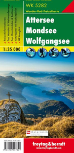
Attersee - Mondsee - Wolfgangsee Freytag & Berndt Map

Attersee - Mondsee - Wolfgangsee area of the Salzkammergut presented at 1:35, 000 in a series of contoured and GPS compatible outdoor leisure map from Freytag & Berndt with hiking and cycling routes, mountain huts, campsites and youth hostels, local bus stops, plus other tourist information. Cartography is an enlargement of the publisher’s coverage of this area at 1:50, 000, with larger print and greater legibility but with the same detail.To see the list of currently available titles in this series please click on the series link.Freytag & Berndt’s outdoor leisure maps cover the whole of Austria at 1:50, 000, with selected popular areas also presented with 50K cartography enlarged to 1:35, 000 for larger print and clearer legibility. The maps have contours at 100m intervals in
the mountainous areas and 50m elsewhere, enhanced by shading, graphic relief and colouring for woodlands. The overprint highlighting waymarked hiking trails is graded into three types: easy walks, mountain paths, and more difficult alpine sections. Waymarked trails including long-distance routes are annotated with their numbers and/or signs. The maps also highlight cycling and mountain biking routes, cross-country ski tracks, and Nordic walking tracks. Symbols indicate mountain huts, youth hostels, campsites and countryside hotels/inns, bus stops on local roads, car parks plus various facilities and places of interest. The maps have a 2-km UTM grid, plus latitude and longitude margin ticks at 5’ intervals. Selected titles also have in the accompanying booklet (see below) an
additional list of GPS waypoints indicated on the map. Map legend includes English.IMPORTANT, PLEASE READ BEFORE ORDERING: most titles come with booklets in GERMAN containing extensive additional information including an index of main locations, suggestions for walks (often accompanied by route profiles) and other recreational activities, lists of mountain huts and other recommended accommodation, etc. Unless specified in the title’s individual description, all the information is in German only and no English language version of the booklet is available. Some titles carry similar information on the reverse.
RIP - This product is no longer available on our network. It was last seen on 25.09.2019

This page now acts as a permanent archive for this product. Add more information using the comments box below to ensure it can still be found by future generations.

Use our search facility to see if it is available from an alternative contributor.
  • Availability: Out Of Stock
  • Supplier: Stanfords
  • SKU: 9783707907841
Availability: In Stock
£9.99

Product Description

Attersee
- Mondsee
- Wolfgangsee area of the Salzkammergut presented at 1:35, 000 in a series of contoured & GPS compatible outdoor leisure map from Freytag & Berndt with hiking & cycling routes, mountain huts, campsites & youth hostels, local bus stops, plus other tourist information. Cartography is an enlargement of the publisher’s coverage of this area at 1:50, 000, with larger print & greater legibility but with the same detail. To see the list of currently available titles in this series please click on the series link. Freytag & Berndt’s outdoor leisure maps cover the whole of Austria at 1:50, 000, with selected popular areas also presented with 50K cartography enlarged to 1:35, 000 for larger print & clearer legibility. The maps have contours at 100m intervals in the mountainous areas & 50m elsewhere, enhanced by shading, graphic relief & colouring for woodlands. The overprint highlighting waymarked hiking trails is graded into three types: easy walks, mountain paths, & more difficult alpine sections. Waymarked trails including long-distance routes are annotated with their numbers and/or signs. The maps also highlight cycling & mountain biking routes, cross-country ski tracks, & Nordic walking tracks. Symbols indicate mountain huts, youth hostels, campsites & countryside hotels/inns, bus stops on local roads, car parks plus various facilities & places of interest. The maps have a 2-km UTM grid, plus latitude & longitude margin ticks at 5’ intervals. Selected titles also have in the accompanying booklet (see below) an additional list of GPS waypoints indicated on the map. Map legend

Includes::
English.IMPORTANT, PLEASE READ BEFORE ORDERING: most titles come with booklets in GERMAN containing extensive additional information including an index of main locations, suggestions for walks (often accompanied by route profiles) & other recreational activities, lists of mountain huts & other recommended accommodation, etc. Unless specified in the title’s individual description, all the information is in German only & no English language version of the booklet is available. Some titles carry similar information on the reverse.

Reviews/Comments

Add New

Intelligent Comparison

Oooops!
We couldn't find anything!
Perhaps this product's unique.... Or perhaps we are still looking for comparisons!
Click to bump this page and we'll hurry up.

Price History

Vouchers

No voucher codes found.
Do you know a voucher code for this product or supplier? Add it to Insights for others to use.

Facebook

Jargon Buster

GPS - Global Positioning System - Global position using satellites
Hiking - An outdoor activity envolving walking in nature
Car - A machine used for transport which runs on roads
Language - the method of communication used in different areas. Humans and computers have many different languages.
Km - Kilometre. A unit of measurement equal to 1000 metres.
Accommodation - A room in which someone can live in, for example in a hotel
Popular - Something that is admired and liked by many people.
Individual - A single separate item or person.
Print - A mechanical process of putting text onto paper. It can also relate to a pattern on an item.
Language - The way humans communicate either written and spoken.

Supplier Information

Stanfords
Stanfords was established in 1853 and opened their iconic Covent Garden flagship store in 1901. They have become the top retailer of maps, travel books and accessories in the UK and arguably offer the largest selection of maps and travel books worldwide. Famous names such as Captain Robert Falcon Scott, Ranulph Fiennes and Michael Palin have purchased from Stanfords. They now have a shop in Bristol and both stores together with other venues operate a calendar of events including talks, book signings and exhibitions. As a specialist map retailer, the map selection is comprehensive and includes road maps, street maps and walking maps from worldwide destinations, as well as a selection of world atlases and wall maps. Books include travel guides and travel literature. Stanfords also stock globes, from miniatures made of blue marble to magnificent floor-standing globes. The website features a selection of interesting articles on travel topics.
Page Updated: 2023-11-12 20:15:36

Community Generated Product Tags

Oh No! The productWIKI community hasn't generated any tags for this product yet!
Menu