
 United Kingdom
 France
 Germany
 Netherlands
 Sweden
 USA
USA
 Italy
Italy
 Spain
Spain
More From Contributor


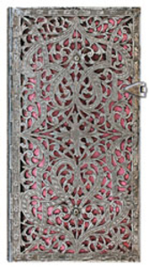
Blush Pink Slim Lined Notebook
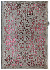
An intricate yet delicate pattern of silver scrolling overlaying a vivid pink background creates an almost three dimension effect on the cover of this silvered meditation on the nature of beauty. The filigree pattern adorning the cover was originally designed and handcrafted in Germany circa 1800. To achieve the gilded and polished motif, a base layer of silver sheets was die cut, and elaborate grooves were then meticulously etched into its surface. You’ll be scratching your head to think of something worthy to write in this beautiful lined notebook! These books have an ornate and subtly weighted magnetic clasp for secure closing, satin ribbon page markers and a memento pouch. Smythe sewn, 208 lined pages, acid-free sustainable forest paper, 90 x 180mm.

Product Description
Reviews/Comments
Add New
Intelligent Comparison
Archived Product
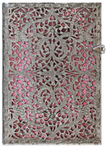
Blush Pink Midi Lined Notebook Stanfords
£19.99
Vouchers
No voucher codes found.
Do you know a voucher code for this product or supplier? Add it to Insights for others to use.
Do you know a voucher code for this product or supplier? Add it to Insights for others to use.
 Denmark