
 United Kingdom
 France
 Germany
 Netherlands
 Sweden
 USA
USA
 Italy
Italy
 Spain
Spain
More From Contributor

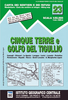


Cinque Terre - Riviera Spezzina Edizioni Multigraphic 506
Cinque Terre National Park along the Ligurian coast at 1:25, 000 on a contoured and GPS compatible map from Edizioni Multigraphic presenting local hiking trails with their new official waymarking numbers. Coverage extends from Deiva Marina in the west to Seno di Fosola bay, so does not include the south-easternmost tip of the Park around Portovenere or La Spezia.Contours are at 20m intervals, with relief shading and spot heights. Hiking trails are annotated with their official waymarking – please see the note below – at the map also indicate picturesque locations, visitors’ centres, museums, etc. The map has a 1km UTM grid, plus latitude and longitude margin ticks at 5’ intervals. Map legend and notes about the area include English.PLEASE NOTE: the map, published in summer
2016, has a list of hiking trails with a note “Hiking trails here are represented by the new numbering plan according to the standard of Regione Liguria. The full list of trails with the walking times in ascent and descent is reported below. Old trail numbers, if available, are reported in brackets. The update of signage to the new numbering plan is in progress. Signals with the old trail numbers might still be present in the field.”To see the list of titles in this Ed. Multigraphic series please click on the series link.
2016, has a list of hiking trails with a note “Hiking trails here are represented by the new numbering plan according to the standard of Regione Liguria. The full list of trails with the walking times in ascent and descent is reported below. Old trail numbers, if available, are reported in brackets. The update of signage to the new numbering plan is in progress. Signals with the old trail numbers might still be present in the field.”To see the list of titles in this Ed. Multigraphic series please click on the series link.

Product Description
Reviews/Comments
Add New
Vouchers
No voucher codes found.
Do you know a voucher code for this product or supplier? Add it to Insights for others to use.
Do you know a voucher code for this product or supplier? Add it to Insights for others to use.
 Denmark