
 United Kingdom
 France
 Germany
 Netherlands
 Sweden
 USA
USA
 Italy
Italy
 Spain
Spain
More From Contributor


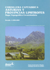
Cordillera Blanca North
Cordillera Blanca North on one of two GPS compatible topographic maps at 1:75, 000 from Aoneker, publishers of an extensive series of similar maps of the Andes in Chile and Argentina. This title covers the area from Milluachocha to Huascaran and Chequiaraju, including Cedros, Sant Cruz, Paron, Alpamayo and Chopicalqui.Contours at 25m intervals are superimposed on a base map derived from satellite imagery, with additional colouring for glaciers and forests. The maps show local paved or dirt roads and 4WD tracks, and highlight trekking trails, distinguishing between main routes and secondary ones. Symbols show locations of mountain huts and refuges, ranger stations, established campsites and climbers camping sites. The maps have latitude and longitude lines at intervals of 1
Product Description
Reviews/Comments
Add New
Intelligent Comparison
Archived Product
Cordillera Blanca South Stanfords
£14.95
Archived Product

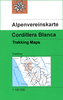
Cordillera Blanca North Alpenverein 0/3A Stanfords
£14.50
Vouchers
No voucher codes found.
Do you know a voucher code for this product or supplier? Add it to Insights for others to use.
Do you know a voucher code for this product or supplier? Add it to Insights for others to use.
 Denmark