
 United Kingdom
 France
 Germany
 Netherlands
 Sweden
 USA
USA
 Italy
Italy
 Spain
Spain
More From Contributor


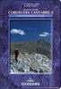

Cordillera Cantabrica
The mountains of Cordillera Cantábrica on detailed road map from the Spanish civilian survey organization, with the same cartography as their Provincial series at 1:200, 000, but combining on one sheet a wider area centred on the Picos de Europa. The map has contours at 100m intervals enhanced by relief shading and shows plenty of names of local sierras, peaks, valleys and other topographic features, plus names of national parks and other protected areas. The network of minor local roads and tracks is shown in great detail and railway lines are included. Latitude and longitude are given as margin ticks at 15’ intervals. Map legend is in Spanish only.IMPORTANT - PLEASE READ BEFORE ORDERING: this map was published in 1995 and with the subsequent rapid expansion of road infrastructure
in Spain, particularly of the motorway network, it does not provide up to date road information. It is sold mainly for its excellent presentation of the area’s varied topography, its sierras, national and natural parks, etc.
in Spain, particularly of the motorway network, it does not provide up to date road information. It is sold mainly for its excellent presentation of the area’s varied topography, its sierras, national and natural parks, etc.
Product Description
Reviews/Comments
Add New
Vouchers
No voucher codes found.
Do you know a voucher code for this product or supplier? Add it to Insights for others to use.
Do you know a voucher code for this product or supplier? Add it to Insights for others to use.
 Denmark