More From Contributor

£14.95
Cordillera Blanca South on one of two GPS compatible topographic maps at 1:75, 000 from Aoneker, publishers of an extensive series of similar maps of the Andes in Chile & Argentina. This title covers the area from Vicos to Yanamarey, extending west to Huaraz & including Ishinca, Tocllaraju, Llaca, Churup, Cojup, Quilquihuanca & Shaqsha. Contours at 25m intervals are superimposed on a base map derived from satellite imagery, with additional colouring for glaciers & forests. The maps show local paved or dirt roads & 4WD tracks, & highlight trekking trails, distinguishing between main routes & secondary ones. Symbols show locations of mountain huts & refuges, ranger stations, established campsites & climbers camping sites. The maps have latitude & longitude lines at intervals of 1 ...
Archived Product
£14.50
Cordillera Blanca South, one of three excellent maps of the Cordillera Blanca & Huayhuash, highlighting local hiking trails. The maps, produced by the Austrian Alpine Club & updated in mid-2000s, provide a very clear picture of the topography with contours at 50m intervals (25m in Cordillera Huayhuash), spot heights, relief shading, graphics to indicate rocks, scree & moraine & colouring for cultivated areas. Road network

Includes::
dirt tracks & footpaths. Trekking routes & camp sites are highlighted. The maps have a UTM grid & latitude/longitude margin ticks at 5’ intervals. Map legend

Includes::
English.


...
Archived Product
£6.99
The mountains of Cordillera Cantábrica on detailed road map from the Spanish civilian survey organization, with the same cartography as their Provincial series at 1:200, 000, but combining on one sheet a wider area centred on the Picos de Europa. The map has contours at 100m intervals enhanced by relief shading & shows plenty of names of local sierras, peaks, valleys & other topographic features, plus names of national parks & other protected areas. The network of minor local roads & tracks is shown in great detail & railway lines are included. Latitude & longitude are given as margin ticks at 15’ intervals. Map legend is in Spanish only.IMPORTANT
- PLEASE READ BEFORE ORDERING: this map was published in 1995 & with the subsequent rapid expansion of road infrastructure in Spain, particularly of the motorway network, it does not provide up to date road information. It is sold mainly for its excellent presentation of the area’s varied topography, its sierras, national & natural parks, etc.
...
Archived Product
£12.99
Cordillera Cantabrica on a detailed road map at 1:200, 000 from the Oviedo based Adrados Ediciones, presenting this mountainous region with contours at 100m intervals, altitude coluring, relief shading & UTM coordinates, plus on the reverse a panorama of the region. Since the publishers specialize in detailed hiking maps, including the best coverage of the Picos de Europa, the map

Includes::
an exceptionally large number of names of peaks, passes, etc. Symbols highlight best rock & ice climbing areas, huts & refuges, campsites, mountain rescue posts & information centres. Along the coast numerous beaches are named. Road network

Includes::
small country roads & tracks. Local railway lines are shown, although not very easy to see on the base map filled with so much information. The map has a 10km UTM grid. Map legend is in Spanish only. On the reverse is a panorama drawing of the area, looking south from the coast with León & Pontevedra in the background. Numerous towns & villages, as well as peaks of the Cordillera Cantabrica are named. An administrative map of the area shows its division into communes & highlights its many protected areas, accompanied by an index listing, where appropriate, each commune with its highest peak. Also included is a very extensive list of all the peaks in the Cordillera Cantabrica over 1200m. Accompanying notes are in Spanish only. PLEASE NOTE: all place names are in the local dialect, so Xixon for Gijón, Uvieu for Oviedo, etc. The map is printed on glossy paper & may not withstand repeated folding & unfolding whilst traveling by car, but it is ideal for finding out more about this fascinating region outside its main attraction, the Picos de Europa..


...
Archived Product
£15.00
Robin Walker’s Cicerone guide to Walking in the Cordillera Cantabrica explores one of Spain’s premier mountain ranges. It


...
Archived Product
£14.50
Cordillera Huayhuash, one of three excellent maps of the Cordillera Blanca & Huayhuash, highlighting local hiking trails. The maps, produced by the Austrian Alpine Club & updated in mid-2000s, provide a very clear picture of the topography with contours at 50m intervals (25m in Cordillera Huayhuash), spot heights, relief shading, graphics to indicate rocks, scree & moraine & colouring for cultivated areas. Road network

Includes::
dirt tracks & footpaths. Trekking routes & camp sites are highlighted. The maps have a UTM grid & latitude/longitude margin ticks at 5’ intervals. Map legend

Includes::
English.


...
Archived Product
£14.50
Cordillera Real North: Illampu, one of two hiking maps of the Cordillera Real produced by the German & Austrian Alpine Clubs. Physical relief is shown by contours at 40m intervals, spot heights & hill-shading. Further graphics show natural terrain features e.g. rock faces, glaciers, swamps & forests. Varying grades of road are shown, including dirt tracks & footpaths. UTM coordinates are given in the margins, plus latitude & longitude ticks at 1` intervals. Map legend is in Spanish & German only. This northern sheet is Approx. centred on Illampu &

Includes::
Calzada peak & the lakes Jistaña & Cacha in the south, & the town Sorata in the north.

...
Archived Product
£14.50
Cordillera Real South: Illimani, one of two hiking maps of the Cordillera Real produced by the German & Austrian Alpine Clubs. Physical relief is shown by contours at 40m intervals, spot heights & hill-shading. Further graphics show natural terrain features e.g. rock faces, glaciers, swamps & forests. Varying grades of road are shown, including dirt tracks & footpaths. UTM coordinates are given in the margins, plus latitude & longitude ticks at 1` intervals. Map legend is in Spanish & German only. This southern sheet covers the area of Nevado Mururata & Nevado Illimani & their approaches. ...
Archived Product
£11.95
Indexed street plan of Cordoba (Argentina) with an enlargement for the city centre. The main plan covers the whole of the city including its outer suburbs, clearly showing road access to the city centre form the ring road. Separate indexes are provided for streets & names of barrios. Also included is a list of ferry stops along the Rio Suqu ...
Archived Product
£6.95
Topographic coverage of mainland Spain at 1:50, 000 in the MTN50 (Mapa Topográfico Nacional) series from the Centro Nacional de Información Geografica, the country’s civilian survey organization. The maps have contours at 20m intervals, enhanced by relief shading, plus colouring and/or graphics to show different types of terrain, vegetation or land use. Boundaries of national parks & other protected areas are marked. In addition to all the usual information featured on topographic mapping at this scale, detailed presentation of the road & rail networks, rural tracks & paths, etc, the maps also show campsites & mountain refuges. On more recent editions some GRs, the official long-distance hiking routes, are also marked (although not as clearly as on hiking maps from other publishers). Each map covers 29.5x 18.5 km (with adjustments in the border or coastal areas). The maps have a 1-km UTM grid, plus margin ticks for latitude & longitude at 1` intervals. Map legend is in Spanish only.HOW TO CHOOSE THE RIGHT 50K MAP: all the titles in CNIG’s 200K Provincial Road Maps series at 1:200, 000 are overprinted with the grid for the 1:50, 000 maps & can be used to see the area covered by each 50K title. TO SEE THE LIST OF TITLES IN THIS SERIES PLEASE CLICK ON THE SERIES LINK.PLEASE NOTE
- MAP TITLES: the grids shown on our website serve both the civilian & the military 1:50, 000 topographic series. Although the areas covered by maps in both series are identical (apart from some border or coastal sheets), occasionally map titles differ – only one title is shown on the grid, usually the military one. In Galicia, the Basque country & in the Catalan speaking areas the tendency now is to use local place names rather than the often better known Castilian ones. Where possible, both versions are included in our titles. Map titles listed on our website are based on information received by us at the time of publication, but sometimes maps arrive showing a completely different title! As long as the map number is as ordered, the correct map has been supplied.
...
Archived Product

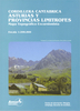
Cordillera Cantabrica: Asturias And The Surrounding Provinces

Cordillera Cantabrica on a detailed road map from the Oviedo based Adrados Ediciones, presenting this mountainous region with contours at 100m intervals, altitude coluring, relief shading and UTM coordinates.Since the publishers specialize in detailed hiking maps, including the best coverage of the Picos de Europa, the map includes an exceptionally large number of names of peaks, passes, etc. Symbols highlight best rock and ice climbing areas, huts and refuges, campsites, mountain rescue posts and information centres. Along the coast numerous beaches are named.Road network includes small country roads and tracks. Local railway lines are shown, although not very easy to see on the base map filled with so much information. The map has a 10km UTM grid. Map legend is in Spanish
only.On the reverse is a panorama drawing of the area, looking south from the coast with Le
RIP - This product is no longer available on our network. It was last seen on 25.09.2019

This page now acts as a permanent archive for this product. Add more information using the comments box below to ensure it can still be found by future generations.

Use our search facility to see if it is available from an alternative contributor.
  • External links may include paid for promotion
  • Availability: Out Of Stock
  • Supplier: Stanfords
  • SKU: XL00000107907
Availability: In Stock
£7.50

Product Description

Cordillera Cantabrica on a detailed road map from the Oviedo based Adrados Ediciones, presenting this mountainous region with contours at 100m intervals, altitude coluring, relief shading & UTM coordinates. Since the publishers specialize in detailed hiking maps, including the best coverage of the Picos de Europa, the map

Includes::
an exceptionally large number of names of peaks, passes, etc. Symbols highlight best rock & ice climbing areas, huts & refuges, campsites, mountain rescue posts & information centres. Along the coast numerous beaches are named. Road network

Includes::
small country roads & tracks. Local railway lines are shown, although not very easy to see on the base map filled with so much information. The map has a 10km UTM grid. Map legend is in Spanish only. On the reverse is a panorama drawing of the area, looking south from the coast with Le

Reviews/Comments

Add New

Price History

Vouchers

No voucher codes found.
Do you know a voucher code for this product or supplier? Add it to Insights for others to use.

Facebook

Jargon Buster

Hiking - An outdoor activity envolving walking in nature
Ice - Frozen water, the solid state of water.
Spanish - The main language spoken in Spain and Latin America.
Network - A link and communication between things. Often computers or people.
Large - something that takes up more space than normal.
Small - something that takes up less space than normal.
Road - a manmade lane or a path that is used to speed up travel.
Ice - Frozen water, Ice is cold to the touch and forms when water reaches 0 degrees centigrade.
Altitude - Something that can be quite high in relation to sea or ground level.

Supplier Information

Stanfords
Stanfords was established in 1853 and opened their iconic Covent Garden flagship store in 1901. They have become the top retailer of maps, travel books and accessories in the UK and arguably offer the largest selection of maps and travel books worldwide. Famous names such as Captain Robert Falcon Scott, Ranulph Fiennes and Michael Palin have purchased from Stanfords. They now have a shop in Bristol and both stores together with other venues operate a calendar of events including talks, book signings and exhibitions. As a specialist map retailer, the map selection is comprehensive and includes road maps, street maps and walking maps from worldwide destinations, as well as a selection of world atlases and wall maps. Books include travel guides and travel literature. Stanfords also stock globes, from miniatures made of blue marble to magnificent floor-standing globes. The website features a selection of interesting articles on travel topics.
Page Updated: 2023-11-12 20:15:36

Community Generated Product Tags

Oh No! The productWIKI community hasn't generated any tags for this product yet!
Menu