
 United Kingdom
 France
 Germany
 Netherlands
 Sweden
 USA
USA
 Italy
Italy
 Spain
Spain
More From Contributor

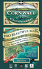


Cornwall West: Lands End To Bodmin/St Austell Cycle Map
The western half of Cornwall at 1:100, 000 on a handy size, 50x35cm, double-sided contoured map from Croydecycle, printed on waterproof and tear-resistant synthetic paper and showing National Cycle routes and numerous local facilities, including campsites, pubs, etc. Coverage extends east to St Austell, Wadebridge and Port Isaac, overlapping with the publishers’ map of east Cornwall, and includes the Eden Project. Contours are at 30m intervals, with colouring for woodlands (indicating those with public access), sandy or pebble beaches, plus moors and common or other access land. Interesting landscape and man- made features are highlighted with grading. Road network indicates A and B road numbers and has gradient markings. On roads which are part of the National Cycle Network
route numbers are marked. Symbols indicate numerous facilities: campsites and caravan sites, pubs and cafes, car parks and picnic sites, local shops, cycle hire, tourist information, etc. National Grid coordinates are marked in the margins. Small panels provide street plans of central St Austell, Truro, Newquay, Wadebridge, St Ives, Penzance, Hayle, Helston, Redruth and Falmouth.To see other titles in this series please click on the series link.
route numbers are marked. Symbols indicate numerous facilities: campsites and caravan sites, pubs and cafes, car parks and picnic sites, local shops, cycle hire, tourist information, etc. National Grid coordinates are marked in the margins. Small panels provide street plans of central St Austell, Truro, Newquay, Wadebridge, St Ives, Penzance, Hayle, Helston, Redruth and Falmouth.To see other titles in this series please click on the series link.

Product Description
Reviews/Comments
Add New
Vouchers
No voucher codes found.
Do you know a voucher code for this product or supplier? Add it to Insights for others to use.
Do you know a voucher code for this product or supplier? Add it to Insights for others to use.
 Denmark