More From Contributor

£6.99
Cornwall on a lovely pictorial map presenting on one side the county’s “ Heritage & Culture” & on the reverse its “ Environment & Nature”, both accompanied with numerous panels providing more information by drawings & descriptions. Smaller roads are included where leading to the various highlighted locations, rather than the map presenting the whole of the road network. Interesting locations are presented by small drawings & many are also accompanied by brief notes. On each side, the road map is surrounded by numerous panels with drawings and/or text providing further information: from a recipe for a Cornish pasty to Cornish language, myth & legends, smuggling & ship wrecks, etc. The Environment & Nature side has lovely drawings of local birds & flowers. ...
Archived Product
£12.95
This guidebook offers walkers 40 half to full day rambles on the coasts & inland hills of Cornwall. With routes ranging from short, 2 mile strolls to longer walks of over 8 miles, as well as plenty of opportunities to combine routes together, this guide provides plenty of variety for walkers of all abilities. The guidebook is divided into sections, including walks on Bodmin Moor (for which good navigational skills are required), the North coast, Penwith & West Cornwall, the Inland Mining Districts, Land`s End & the Lizard & Roseland Peninsulas. Cornwall has a lot to offer walkers; stunning coastal scenery & long stretches of wild moorl&, with quiet estuaries cutting through high & rocky headlands. Birdlife & wildlife, from choughs to falcons to seals are found throughout the county, as are historical sites from the neolithic, to Iron Age hill forts & a long history of mining. The towns & villages of Cornwall, from the popular spots such as St Ives, Newquay & Padstow, to quiet inland hamlets & tucked away fishing villages are also included & provide perfect bases for going out to explore the country. Alongside the 40 walking routes, this guidebook also

Includes::
plenty of practical information on getting to & around Cornwall, as well as details on each walk`s distance, timing, terrain, ascent & nearest town. Throughout the walk descriptions, there are details of places of interest along the way, as well as annotated OS maps & stunning photography. The result is an ideal companion to stepping out & exploring the best of Cornwall.

...
Archived Product
£11.99
Cornwall Walks in the Pathfinder Guides series, produced in association with Ordnance Survey & published by Crimson; comprising a range of walking guides to popular British destinations. Each Pathfinder guide

Includes::
28 varied walks ranging from easy strolls to exhilarating hikes & is accompanied by 1:25, 000 Ordnance Survey mapping with marked, colour-coded routes. Introductory sections profile the county or region covered, with recommendations on the best time to visit & a brief explanation of GPS. An

...
Archived Product
£2.99
The western half of Cornwall at 1:100, 000 on a handy size, 50x 35cm, double-sided contoured map from Croydecycle, printed on waterproof & tear-resistant synthetic paper & showing National Cycle routes & numerous local facilities, including campsites, pubs, etc. Coverage extends east to St Austell, Wadebridge & Port Isaac, overlapping with the publishers’ map of east Cornwall, &

Includes::
the Eden Project. Contours are at 30m intervals, with colouring for woodlands (indicating those with public access), sandy or pebble beaches, plus moors & common or other access l&. Interesting landscape & man- made features are highlighted with grading. Road network indicates A & B road numbers & has gradient markings. On roads which are part of the National Cycle Network route numbers are marked. Symbols indicate numerous facilities: campsites & caravan sites, pubs & cafes, car parks & picnic sites, local shops, cycle hire, tourist information, etc. National Grid coordinates are marked in the margins. Small panels provide street plans of central St Austell, Truro, Newquay, Wadebridge, St Ives, Penzance, Hayle, Helston, Redruth & Falmouth. To see other titles in this series please click on the series link.

...
Archived Product
£10.99
Cornwall, Devon & Somerset in the Cadogan guide series; covering a range of destinations – primarily in Europe
- & combining solid
...
Archived Product
£11.99
Cornwall, Devon & Sudwestengland in a German language version in the Countries & Regions series from Lonely Planet, market-leading comprehensive guides aimed at independent travellers & serving a large range of international destinations. Frank & informal in style, the guides explore an extensive range of sights, activities, accommodation, restaurants & nightlife & are designed for practical use while travelling on the road. Written & researched by a team of experts, each book is independent in its recommendations & suggestions, often offering individual takes on individual destinations. Widely recognised for their reliability, each Lonely Planet country & region guide has the same layout. Introductory sections profile the destination with individual chapters on particular highlights, getting started, (including when to go) itineraries, history, culture, arts, food & drink & the environment. Each guide is organised geographically by region, with individual sections detailing an extensive range of sights, places of interest, attractions, restaurants, nightlife, accommodation & any local activities. The guides have detailed explanations of historical context where relevant. There is also practical guidance on ...
Archived Product
£9.99
Cornwall in the AA 50 Walks series; comprising an extensive range of walking guides helping you to explore the best walking routes in Great Britain. Each guide covers a total of 50 walks, many of which are circular, between 2-10 miles & also that are suitable for a range of different walking standards. Every walk in the guides has an information box showing clear details of distance, minimum time, level of difficulty, any ascents, the nature of the terrain & landscape, suggested Ordnance Survey map, grid references for starting & finishing points, dog friendliness, parking & any public toilets en route. There are also suggestions of what to look out for & recommended places to eat & drink. Detailed walk descriptions are accompanied by clear mapping of the route ahead, in addition to colour photographs illustrating the highlights of selected routes. ...
Archived Product
£11.99
Walking is one of Britain`s favourite leisure activities, & this fantastic walking guide to Cornwall features a variety of mapped walks to suit all abilities. The book features all the practical detail you need, accompanied by fascinating background reading on the history & wildlife of the area, as well as other local points of interest. All walks are annotated with local points of interest & places to stop for refreshments & every walk is given a summary of distance, time, gradient, level of difficulty, type of surface & access, landscape, dog friendliness, parking & public toilets. ...
Archived Product
£2.95
Double-sided, waterproof, leisure & cycle map of Cornwall at 1:100, 000 from Croyde Cycle, with enlargements of town & city centres at 1:7, 500. Regional & national cycle paths, bridleways, footpaths, & permissive paths are prominently indicated. Road networks are shown, with busy, main, & minor roads differentiated, as well as private roads allowing access on foot/bike. Topography is indicated through spot heights, contour lines (at 30m intervals), & steep hill symbols, with colour used for different terrain types. Points of interest & local facilities such as information points, pubs, camp sites, accommodation & toilets are highlighted. Limited access, geological, & historical information is marked on some parts of the map. Enlargements at 1:7, 500 are included of: Plymouth city centre; Newquay; Truro; St Austell; Falmouth; Penzance; St Ives; Falmouth; Helston; Bude; Bodmin; Tavistock; Lostwithiel; Fowey; Liskeard; & Looe. These show one-way streets & local facilities, including parking & cycle hire. The National Grid is indicated by margin ticks, making the map GPS compatible. ...
Archived Product

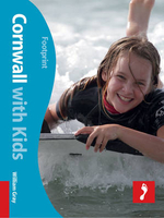
Cornwall With Kids: Includes Isles Of Scilly

Britain`s most popular holiday destination has been left with no stone unturned in updating the second edition of Footprint`s full-colour guide, Cornwall with Kids. This popular guide provides you with the complete low-down on where to go, what to see and how to get the most from your family holiday. Cornwall is everything a family holiday should be - braving surf, building sandcastles and sampling fish and chips.Perfect for any family budget, Cornwall with Kids offers insight into exactly where to pitch the tent, buy local food and plan days out for free, plus reviews of the top hotels along with the must-see attractions like the Eden Project and St Michael`s Mount. Whether it`s a day trip to the Isles of Scilly or finding the best beaches for rockpooling that takes your fancy, you
won`t want to leave home without this full-colour guide. - Teach the kids how to surf at one of the many acclaimed North Atlantic surf schools. - Sample the culinary delights, full listings on where to find the best Cornish food, including that perfect pasty. - Great days out, from the Eden Project to the Lost Gardens of Heligan.Whether the sun is blazing or the rain is pouring, there are tips here for all weather.
RIP - This product is no longer available on our network. It was last seen on 25.09.2019

This page now acts as a permanent archive for this product. Add more information using the comments box below to ensure it can still be found by future generations.

Use our search facility to see if it is available from an alternative contributor.
  • Availability: Out Of Stock
  • Supplier: Stanfords
  • SKU: 9781907263866
Availability: In Stock
£13.99

Product Description

Britain`s most popular holiday destination has been left with no stone unturned in updating the second edition of Footprint`s full-colour guide, Cornwall with Kids. This popular guide provides you with the complete low-down on where to go, what to see & how to get the most from your family holiday. Cornwall is everything a family holiday should be
- braving surf, building sandcastles & sampling fish & chips. Perfect for any family budget, Cornwall with Kids offers insight into exactly where to pitch the tent, buy local food & plan days out for free, plus reviews of the top hotels along with the must-see attractions like the Eden Project & St Michael`s Mount. Whether it`s a day trip to the Isles of Scilly or finding the best beaches for rockpooling that takes your fancy, you won`t want to leave home without this full-colour guide.
- Teach the kids how to surf at one of the many acclaimed North Atlantic surf schools.
- Sample the culinary delights, full listings on where to find the best Cornish food, including that perfect pasty.
- Great days out, from the Eden Project to the Lost Gardens of Heligan. Whether the sun is blazing or the rain is pouring, there are tips here for all weather.

Reviews/Comments

Add New

Intelligent Comparison

Oooops!
We couldn't find anything!
Perhaps this product's unique.... Or perhaps we are still looking for comparisons!
Click to bump this page and we'll hurry up.

Price History

Vouchers

No voucher codes found.
Do you know a voucher code for this product or supplier? Add it to Insights for others to use.

Facebook

Jargon Buster

sun - A star at the centre of the solar system.
Stone - Or Rock is a naturally occuring mineral categorised into three types, Igneous, Sedimentary and Metamorphic
Colour - The categorised spectrum of light visable to humans
Day - The time it takes a planet or other space objects to complete one rotation.
Weather - is the change of an atmospheres conditions.
Fish - A creature that lives in water. A fish uses gills to breath unlike mammals
Home - A place of permanent residence for families.
Popular - Something that is admired and liked by many people.
Kids - A young child.
Family - A group of people that live together made up from parents and children.

Supplier Information

Stanfords
Stanfords was established in 1853 and opened their iconic Covent Garden flagship store in 1901. They have become the top retailer of maps, travel books and accessories in the UK and arguably offer the largest selection of maps and travel books worldwide. Famous names such as Captain Robert Falcon Scott, Ranulph Fiennes and Michael Palin have purchased from Stanfords. They now have a shop in Bristol and both stores together with other venues operate a calendar of events including talks, book signings and exhibitions. As a specialist map retailer, the map selection is comprehensive and includes road maps, street maps and walking maps from worldwide destinations, as well as a selection of world atlases and wall maps. Books include travel guides and travel literature. Stanfords also stock globes, from miniatures made of blue marble to magnificent floor-standing globes. The website features a selection of interesting articles on travel topics.
Page Updated: 2023-11-12 20:15:36

Community Generated Product Tags

Oh No! The productWIKI community hasn't generated any tags for this product yet!
Menu