
 United Kingdom
 France
 Germany
 Netherlands
 Sweden
 USA
USA
 Italy
Italy
 Spain
Spain
More From Contributor


Cuba - Antilles
Indexed road map of Cuba with inset maps of the western Antilles, the Bahamas, Turks and Caicos, and 3 street plans. Unobtrusive hill-shading shows the major relief features, some spot heights are included and marshes, reefs and mangrove areas are shown. Road classification includes dirt-roads, and intermediate road distances on main routes are indicated. Airports, railways, bus terminals, ports and ferries are also included. Administrative region boundaries and names are shown. Symbols show national parks, campsites, beaches, spas, hunting and angling spots, caves and lighhouses and other sites of interest. Longitude and latitude lines are drawn at 1
Product Description
Reviews/Comments
Add New
Intelligent Comparison
Archived Product
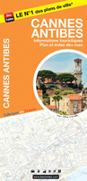
Cannes - Antibes Stanfords
£8.50
Vouchers
No voucher codes found.
Do you know a voucher code for this product or supplier? Add it to Insights for others to use.
Do you know a voucher code for this product or supplier? Add it to Insights for others to use.
 Denmark