
 United Kingdom
 France
 Germany
 Netherlands
 Sweden
 USA
USA
 Italy
Italy
 Spain
Spain
More From Contributor


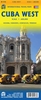
Cuba TerraQuest Adventure Map
Cuba on a waterproof and tear-resistant, double-sided map at 1:650, 000 from terraQuest, with street plans of central Havana and the Varadero peninsula. The map is presented in a special format handy for conveniently viewing just small sections of it at one time.The map divides Cuba east/west, with a small overlap between the sides. Road network includes local roads and selected tracks, with driving distances marked on main and most secondary routes. Railway lines are included and local airports are marked. Symbols highlight various facilities and places of interest including campsites, UNESCO World Heritage sites, beaches and diving sites, etc. Topography is indicated by contours with names of mountain ranges, etc, and colouring for woodlands. Latitude and longitude lines are
drawn at 10’ intervals and the map has no index. A large panel presents central Havana, from the Old Town to the Palacio de la Revolución, at 1:17, 000 highlighting hotels, important buildings, etc. Another panel shows the Varadero peninsula at 1:15, 000 with names of numerous hotels. The map is laminated in a format similar to the old cloth-dissected maps so that sections of it can be easily folded back without damage, and can be annotated with write-on/wipe-off marker pens.
drawn at 10’ intervals and the map has no index. A large panel presents central Havana, from the Old Town to the Palacio de la Revolución, at 1:17, 000 highlighting hotels, important buildings, etc. Another panel shows the Varadero peninsula at 1:15, 000 with names of numerous hotels. The map is laminated in a format similar to the old cloth-dissected maps so that sections of it can be easily folded back without damage, and can be annotated with write-on/wipe-off marker pens.
Product Description
Reviews/Comments
Add New
Vouchers
No voucher codes found.
Do you know a voucher code for this product or supplier? Add it to Insights for others to use.
Do you know a voucher code for this product or supplier? Add it to Insights for others to use.
 Denmark