
 United Kingdom
 France
 Germany
 Netherlands
 Sweden
 USA
USA
 Italy
Italy
 Spain
Spain
More From Contributor


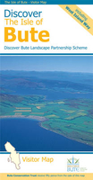
Discover The Isle Of Bute
The Isle of Bute on a contoured and GPS compatible map at 1:30, 000 from Footprint Walks, with a street plan of Rothesay, plus on the reverse extensive tourist information including description of sights, useful contact details, etc. Produced in cooperation with the Discover Bute Landscape Partnership Scheme, the map highlights additional hiking routes recommended by DBLPS and indicates sections of the West Island Way where waymarking on the ground is difficult to follow.Topography is very effectively presented by contours at 10m intervals enhanced by relief shading plus colouring for woodlands. Symbols indicate various facilities including pubs and cafes, shops, public toilets, etc. Ferry connections are marked. The map has 1km lines of the British National Grid. A street plan of
Rothesay shows main facilities in the town. The whole of the reverse side is covered by tourist information: getting to and around the island, places of interest, hiking and cycling, beaches, etc. Where useful, contact details and related web addresses are provided.
Rothesay shows main facilities in the town. The whole of the reverse side is covered by tourist information: getting to and around the island, places of interest, hiking and cycling, beaches, etc. Where useful, contact details and related web addresses are provided.

Product Description
Reviews/Comments
Add New
Vouchers
No voucher codes found.
Do you know a voucher code for this product or supplier? Add it to Insights for others to use.
Do you know a voucher code for this product or supplier? Add it to Insights for others to use.
 Denmark