
 United Kingdom
 France
 Germany
 Netherlands
 Sweden
 USA
USA
 Italy
Italy
 Spain
Spain
More From Contributor


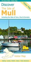
Discover The Isle Of Mull
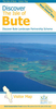
Mull with the nearby islands of Iona, Ulva and Gometra on a contoured and GPS compatible map at 1:65, 000 from Footprint Walks, plus on the reverse extensive tourist information including description of sights, useful contact details, etc. Coverage extends west to include Staffa with its famous Fingal’s Cave, the Treshnish Isles and Bac Mór (Dutchman’s Cap).Topography is very effectively presented by contours at 10m intervals enhanced by relief shading, with plenty of names of peaks, etc, plus colouring for forested areas. Recommended hiking and cycling routes are highlighted. Symbols indicate various facilities including campsites, caravan sites, pubs and cafes, shops and cycle hire, picnic places, etc. Road network shows locations of petrol stations and ferry
connections are marked. The map has 1km lines of the British National Grid. A street plan of Tobermory shows main facilities in the town. The whole of the reverse side is covered by tourist information: ferry connections and getting around the islands, sport and recreational pursuits, best sights including castles and historical buildings, wildlife, etc. Where useful, contact details and related web addresses are provided.
connections are marked. The map has 1km lines of the British National Grid. A street plan of Tobermory shows main facilities in the town. The whole of the reverse side is covered by tourist information: ferry connections and getting around the islands, sport and recreational pursuits, best sights including castles and historical buildings, wildlife, etc. Where useful, contact details and related web addresses are provided.

Product Description
Reviews/Comments
Add New
Vouchers
No voucher codes found.
Do you know a voucher code for this product or supplier? Add it to Insights for others to use.
Do you know a voucher code for this product or supplier? Add it to Insights for others to use.
 Denmark