More From Contributor

£3.50
Hackney in 1870 in a fascinating series of reproductions of old Ordnance Survey plans in the Alan Godfrey Editions, ideal for anyone interested in the history of their neighbourhood or family. Three versions of this map have been published to show how the area developed across the years, stretching from Mare Street eastward to White Post Lane, & from Tresham Avenue & Ashenden Road southward to Victoria Park Road. Features include much of Victoria Park, Hackney Cut Navigation, Hertford Union Canal, Hackney Common, Well Street, Wick Road, Hackney Wick, South Hackney, Homerton; Victoria Park, Homerton & Hackney stations; City of London Union Workhouse (later Institution), Hackney Workhouse, Eastern Fever Hospital, chemical works & factories at the east edge of map, St Thomas`s Square, St John of Jerusalem church, St John`s church, French Hospital, site of Rowe Chapel, Town Hall, Old Town Hall. The 1870 map is especially attractive, notably portraying South Hackney with its leafy gardens. About the Alan Godfrey Editions of the 25” OS Series: Selected towns in Great Britain & Ireland are covered by maps showing the extent of urban development in the last decades of the 19th & early 20th century. The plans have been taken from the Ordnance Survey mapping & reprinted at about 15 inches to one mile (1:4, 340). On the reverse most maps have historical notes & many also include extracts from contemporary directories. Most maps cover about one mile (1.6kms) north/south, one & a half miles (2.4kms) across; adjoining sheets can be combined to provide wider coverage.FOR MORE INFORMATION & A COMPLETE LIST OF ALL AVAILABLE TITLES PLEASE CLICK ON THE SERIES LINK. ...
Archived Product
£3.50
Ealing in 1934 in a fascinating series of reproductions of old Ordnance Survey plans in the Alan Godfrey Editions, ideal for anyone interested in the history of their neighbourhood or family. Two versions of this map show the area stretching from Eccleston Road eastward to Ealing Broadway & Windsor Road, & from Cleveland Road & Castle Bar southward to Grange Road & Churchfield Road. The map covers central & west Ealing. Features include Ealing Broadway station, Castle Hill & Ealing Dean station, Haven Green, Drayton Green, cemetery, Central London District School. Churches include St Stephen`s, St John`s Mattock Lane, Christ Church. Streets include The Avenue, Uxbridge Road, High Street, Eaton Rise, Argyle Road etc. The 1934 map has a 1933 list of private inhabitanmts in Ealing (the list continues on sheets 70 & 71). About the Alan Godfrey Editions of the 25” OS Series: Selected towns in Great Britain & Ireland are covered by maps showing the extent of urban development in the last decades of the 19th & early 20th century. The plans have been taken from the Ordnance Survey mapping & reprinted at about 15 inches to one mile (1:4, 340). On the reverse most maps have historical notes & many also include extracts from contemporary directories. Most maps cover about one mile (1.6kms) north/south, one & a half miles (2.4kms) across; adjoining sheets can be combined to provide wider coverage.FOR MORE INFORMATION & A COMPLETE LIST OF ALL AVAILABLE TITLES PLEASE CLICK ON THE SERIES LINK. ...
Archived Product
£12.99
Ealing, once known as the ` Queen of the Suburbs`, has had a long & varied history. Once a country town in Middlesex, the area became part of the City of London in 1965 & celebrates its fiftieth anniversary as a London borough in 2015. This is the first book to chart the history of Ealing from earliest times to the dawn of the twenty-first century. It draws on many sources, including contemporary diaries, newspapers, parish & borough archives. The reader will learn about the many changes in Ealing as it moved from being part of a manor belonging to the bishop of London to being an independent entity, going on to absorb neighbouring parishes & boroughs in the twentieth century. In Ealing: A Concise History, author Jonathan Oats discusses both the built environment of open spaces, churches, shops & pubs as well as the district`s residents, from little-known diarists, criminals & politicians to key local personalities who played their part in shaping its history. The impact of outside events, such as civil war, plague & the world wars are also explored in this fascinating insight into the history of the West London borough. ...
Archived Product
£3.50
Ealing Common & West Acton in 1894 in a fascinating series of reproductions of old Ordnance Survey plans in the Alan Godfrey Editions, ideal for anyone interested in the history of their neighbourhood or family. Three versions of this map show how the area developed across the years. Coverage stretches from Haven Lane in Ealing eastward to Myrtle Road in Acton. The eastern part of Ealing is shown, including St Matthew`s church, Ealing Common, Ealing Common & West Acton station, Hanger Hill Farm, Hanger Vale. The western part of Acton is also covered & features here include Springfield Park, Steyne Mills, The Elms, The Steyne, The Lodge, Churchfield Road West, Horn Lane. This 1894 version

Includes::
a selection of street directory entries on the reverse, including Chaucer Road, Grange Park/ Road, Hamilton Road, Horn Lane, Inglis Road, Madeley Road, North Common Road, Spencer Road, Steyne Road. About the Alan Godfrey Editions of the 25” OS Series: Selected towns in Great Britain & Ireland are covered by maps showing the extent of urban development in the last decades of the 19th & early 20th century. The plans have been taken from the Ordnance Survey mapping & reprinted at about 15 inches to one mile (1:4, 340). On the reverse most maps have historical notes & many also include extracts from contemporary directories. Most maps cover about one mile (1.6kms) north/south, one & a half miles (2.4kms) across; adjoining sheets can be combined to provide wider coverage.FOR MORE INFORMATION & A COMPLETE LIST OF ALL AVAILABLE TITLES PLEASE CLICK ON THE SERIES LINK.

...
Archived Product
£3.50
Ealing Common & West Acton in 1934 in a fascinating series of reproductions of old Ordnance Survey plans in the Alan Godfrey Editions, ideal for anyone interested in the history of their neighbourhood or family. Three versions of this map show how the area developed across the years. Coverage stretches from Haven Lane in Ealing eastward to Myrtle Road in Acton. The eastern part of Ealing is shown, including St Matthew`s church, Ealing Common, Ealing Common & West Acton station, Hanger Hill Farm, Hanger Vale. The western part of Acton is also covered & features here include Springfield Park, Steyne Mills, The Elms, The Steyne, The Lodge, Churchfield Road West, Horn Lane. On the reverse of the 1934 map is a selection of street directory entries. About the Alan Godfrey Editions of the 25” OS Series: Selected towns in Great Britain & Ireland are covered by maps showing the extent of urban development in the last decades of the 19th & early 20th century. The plans have been taken from the Ordnance Survey mapping & reprinted at about 15 inches to one mile (1:4, 340). On the reverse most maps have historical notes & many also include extracts from contemporary directories. Most maps cover about one mile (1.6kms) north/south, one & a half miles (2.4kms) across; adjoining sheets can be combined to provide wider coverage.FOR MORE INFORMATION & A COMPLETE LIST OF ALL AVAILABLE TITLES PLEASE CLICK ON THE SERIES LINK. ...
Archived Product
£4.99
A quiet night`s sleep is never far away with these super soft ear plugs. Made from flexible memory foam they can be quickly & easily rolled to fit the ear canal, yet they return to their original shape when not in use. Fully reusable & comfy to wear, these foam ear plugs are supplied with a convenient travel carry case ensuring they stay 100% hygienic at all times.3 pairs per pack. ...
Archived Product
£6.99
Wherever you are
- at home, at work or on the move
- feel completely free to lose yourself in a world of blissful hush. Engineered

...
Archived Product
£3.50
Earlestown North in 1910 in a fascinating series of reproductions of old Ordnance Survey plans in the Alan Godfrey Editions, ideal for anyone interested in the history of their neighbourhood or family. The map covers the northern part of Earlestown & southern part of Haydock. Coverage stretches from Haydock Green southward to St John Street & Hotel Street, Earlestown. Features include Earlestown Town Hall, St John the Baptist church, Crow Lane Farm, Haydock Colliery Railway, Newton Race Course (disused), Lyme Pits (disused), Wood Pit Colliery, Haydock Colliery Engine & Wagon Shops, Haydock Green, pumping station, etc. On the reverse is a 1918 directory of Earlestown. About the Alan Godfrey Editions of the 25” OS Series: Selected towns in Great Britain & Ireland are covered by maps showing the extent of urban development in the last decades of the 19th & early 20th century. The plans have been taken from the Ordnance Survey mapping & reprinted at about 15 inches to one mile (1:4, 340). On the reverse most maps have historical notes & many also include extracts from contemporary directories. Most maps cover about one mile (1.6kms) north/south, one & a half miles (2.4kms) across; adjoining sheets can be combined to provide wider coverage.FOR MORE INFORMATION & A COMPLETE LIST OF ALL AVAILABLE TITLES PLEASE CLICK ON THE SERIES LINK. ...
Archived Product
£2.95
Earlestown South in 1891 in a fascinating series of reproductions of old Ordnance Survey plans in the Alan Godfrey Editions, ideal for anyone interested in the history of their neighbourhood or family. Selected towns in Great Britain & Ireland are covered by maps showing the extent of urban development in the last decades of the 19th & early 20th century. In this title: the map covers the southern part of Earlestown, extending westward to Collins Green. Features include Viaduct wagon works, St Helens Canal, Sankey Sugar Works, Vitrioal Square, Collins Green, Collins Green Colliery, LNWR railway with Collins Green station, Sankey Viaduct, Penkford Bridge, Bradley Hall, Haydock Crossing, Earle Street area, King Street area, Newton Common etc. On the reverse is a small Collins Green directory plus a Liverpool-Earlestown-Manchester railway timetable for 1897. About the Alan Godfrey Editions of the 25 ...
Archived Product
£3.50
Earlestown South in 1891 in a fascinating series of reproductions of old Ordnance Survey plans in the Alan Godfrey Editions, ideal for anyone interested in the history of their neighbourhood or family. Two versions have been published to this area. The maps cover the southern part of Earlestown, extending westward to Collins Green. Features include Viaduct wagon works, St Helens Canal, Sankey Sugar Works, Vitrioal Square, Collins Green, Collins Green Colliery, LNWR railway with Collins Green station, part of Earlestown station, Sankey Viaduct, Penkford Bridge, Bradley Hall, Haydock Crossing, Earle Street area, King Street area, Newton Common, etc. On the reverse are Liverpool-Earlestown-Manchester railway timetables for 1897. About the Alan Godfrey Editions of the 25” OS Series: Selected towns in Great Britain & Ireland are covered by maps showing the extent of urban development in the last decades of the 19th & early 20th century. The plans have been taken from the Ordnance Survey mapping & reprinted at about 15 inches to one mile (1:4, 340). On the reverse most maps have historical notes & many also include extracts from contemporary directories. Most maps cover about one mile (1.6kms) north/south, one & a half miles (2.4kms) across; adjoining sheets can be combined to provide wider coverage.FOR MORE INFORMATION & A COMPLETE LIST OF ALL AVAILABLE TITLES PLEASE CLICK ON THE SERIES LINK. ...
Archived Product

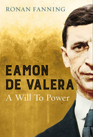
Eamon De Valera: A Will To Power

Eamon de Valera is the most remarkable man in the history of modern Ireland. Much as Churchill personified British resistance to Hitler and de Gaulle personified the freedom of France, de Valera personified Irish independence. From his emergence in the aftermath of the 1916 rebellion as the republican leader, he bestrode Irish politics like a colossus for more than fifty years. On the eve of the centenary of the Irish Revolution, one of Ireland`s most eminent historians explains why Eamon de Valera was such a divisive figure that he has never - until now - received the recognition he deserves. This biography reconciles an acknowledgement of de Valera`s catastrophic failure in 1921-22, when his petulant rejection of the Anglo-Irish Treaty shaped the dimensions of a bloody civil war,
with an appreciation of his subsequent greatness as the statesman who single-handedly severed the ties with Britain and defined nationalist Ireland`s sense of itself.
RIP - This product is no longer available on our network. It was last seen on 25.09.2019

This page now acts as a permanent archive for this product. Add more information using the comments box below to ensure it can still be found by future generations.

Use our search facility to see if it is available from an alternative contributor.
  • Availability: Out Of Stock
  • Supplier: Stanfords
  • SKU: 9780571312054
Availability: In Stock
£20.00

Product Description

Eamon de Valera is the most remarkable man in the history of modern Irel&. Much as Churchill personified British resistance to Hitler & de Gaulle personified the freedom of France, de Valera personified Irish independence. From his emergence in the aftermath of the 1916 rebellion as the republican leader, he bestrode Irish politics like a colossus for more than fifty years. On the eve of the centenary of the Irish Revolution, one of Ireland`s most eminent historians explains why Eamon de Valera was such a divisive figure that he has never
- until now
- received the recognition he deserves. This biography reconciles an acknowledgement of de Valera`s catastrophic failure in 1921-22, when his petulant rejection of the Anglo-Irish Treaty shaped the

Dimensions of a bloody civil war, with an appreciation of his subsequent greatness as the statesman who single-handedly severed the ties with Britain & defined nationalist Ireland`s sense of itself.

Reviews/Comments

Add New

Intelligent Comparison

Oooops!
We couldn't find anything!
Perhaps this product's unique.... Or perhaps we are still looking for comparisons!
Click to bump this page and we'll hurry up.

Price History

Vouchers

No voucher codes found.
Do you know a voucher code for this product or supplier? Add it to Insights for others to use.

Facebook

Jargon Buster

France - A state situated in Western Europe with several overseas territories.
History - Anything that happens in the past. An acedemic subject.
Dimensions - The shapes and angles of something or a situation.

Supplier Information

Stanfords
Stanfords was established in 1853 and opened their iconic Covent Garden flagship store in 1901. They have become the top retailer of maps, travel books and accessories in the UK and arguably offer the largest selection of maps and travel books worldwide. Famous names such as Captain Robert Falcon Scott, Ranulph Fiennes and Michael Palin have purchased from Stanfords. They now have a shop in Bristol and both stores together with other venues operate a calendar of events including talks, book signings and exhibitions. As a specialist map retailer, the map selection is comprehensive and includes road maps, street maps and walking maps from worldwide destinations, as well as a selection of world atlases and wall maps. Books include travel guides and travel literature. Stanfords also stock globes, from miniatures made of blue marble to magnificent floor-standing globes. The website features a selection of interesting articles on travel topics.
Page Updated: 2023-11-12 20:15:36

Community Generated Product Tags

Oh No! The productWIKI community hasn't generated any tags for this product yet!
Menu