
 United Kingdom
 France
 Germany
 Netherlands
 Sweden
 USA
USA
 Italy
Italy
 Spain
Spain
More From Contributor

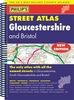

Gloucestershire County Street Atlas SPIRAL-BOUND SUPERCEDED
A brand new edition colour atlas of Gloucestershire, giving the only comprehensive, detailed coverage of the region. No other atlas shows every street in Gloucestershire. The atlas also shows the City of Bristol. The mapping is prepared by Ordance Survey and gives the user complete coverage of all urban and rural areas. The mapping is at a standard scale of 3-1/2 inches to 1 mile (2-1/2 inches to 1 mile in the pocket edition). The more rural areas of the County have a scale of 1 inch to 1 mile (1-1/4 inches to 1 mile in the pocket edition) and is complete with postcode boundaries. The atlas is ideally suited for both business and leisure use. The route-planning map at the front of the atlas has been further improved for this edition. The main maps show every named road, street and lane
clearly with through-routes highlighted. School locations are marked and emergency services, hospitals, police stations, car parks and rail and bus station locations are all featured. Both Cheltenham and Gloucester town centres are shown at the extra large scale of 7 inches to 1 mile.There is a comprehensive index of street names and postcodes including schools, industrial estates, hospitals, sports centres, etc. These are highlighted in red in the spiral atlas.
clearly with through-routes highlighted. School locations are marked and emergency services, hospitals, police stations, car parks and rail and bus station locations are all featured. Both Cheltenham and Gloucester town centres are shown at the extra large scale of 7 inches to 1 mile.There is a comprehensive index of street names and postcodes including schools, industrial estates, hospitals, sports centres, etc. These are highlighted in red in the spiral atlas.
Product Description
Reviews/Comments
Add New
Vouchers
No voucher codes found.
Do you know a voucher code for this product or supplier? Add it to Insights for others to use.
Do you know a voucher code for this product or supplier? Add it to Insights for others to use.
 Denmark