More From Contributor

£5.95
Gloucestershire in a series of colourful reproductions of attractive county maps by John Speede from about 1610-1611, printed on thick art paper & ideal for framing. Each title, 58 x 45cm / approx. 23” x 18”, is decorated with additional notes, drawings, coats of arms, street plans, etc. Little drawings are used to show locations of towns, larger villages, hills & woodlands or parks. Rivers & lakes are also drawn, as are boundaries of the administrative subdivisions with the names of the Hundreds. Surrounding the county are decorative panels filled with additional information which differs from title to title: street plans, coats of arms of notable local families, geographical features, notes about local history, etc. ...
Archived Product
£2.95
Gloucestershire 1610 Replica Map by the Old Map Company is a reproduction of the map created for the famous atlas of the period by the master map maker John Speede Esq. The Old Map Company has recreated the antique maps of British counties, European cities & World countries originally crafted by master map maker John Speede Esq. whose work had accuracy & quality not surpassed for centuries. Each map is treated & presented on specially crafted paper then h&-treated giving it texture & an aged appearance before being beautifully engraved & detailed. ...
Archived Product
£80.00
Gloucestershire, an original antique map by J. Pigot, published in London, c. 1840. A steel plate engraving, original o/l colour. Map size 17 x 10.75 cm with a mount size of 39.5 x 32 cm.A scarce pocket map of Gloucestershire, with the accompanying leaf with the distance table surmounted by a finely engraved view of Gloucester Cathedral. The map was published by James Pigot who started his career as an engraver for Dean's Manchester Directory, but later set up his own business publishing the London & Provincial New Commercial Directory & other works. Antique maps from various original publishers are presented on the Stanford ...
Archived Product
£6.99
Street atlas of Gloucestershire, South Gloucestershire & Bristol from Philip's, with enlarged city centre mapping of Gloucester, Cheltenham & Bristol. The street mapping has been sourced from Ordnance Survey data with bold road classification colouring on a plain white base; main mapping is at 1:23, 810 & 1:47, 620. These scales show motorways, A & B roads, & minor roads, with names clearly displayed; railways lines & stops, bus stops, & tramway lines & stops are marked. Local facilities such as post offices, police & fire stations, schools, car parks & mare are displayed. The enlarged city centre maps of Gloucester, Cheltenham & Bristol, shows streets in greater detail at Approx. 1:11, 900, with one ways streets prominently highlighted. All mapping is indexed by street name, with highlighted schools, industrial estates, hospitals, & sports centres
- towns & villages included.
...
Archived Product
£9.99
A brand new edition colour atlas of Gloucestershire, giving the only comprehensive, detailed coverage of the region. No other atlas shows every street in Gloucestershire. The atlas also shows the City of Bristol. The mapping is prepared by Ordance Survey & gives the user complete coverage of all urban & rural areas. The mapping is at a standard scale of 3-1/2 inches to 1 mile (2-1/2 inches to 1 mile in the pocket edition). The more rural areas of the County have a scale of 1 inch to 1 mile (1-1/4 inches to 1 mile in the pocket edition) & is complete with postcode boundaries. The atlas is ideally suited for both business & leisure use. The route-planning map at the front of the atlas has been further enhanced for this edition. The main maps show every named road, street & lane clearly with through-routes highlighted. School locations are marked & emergency services, hospitals, police stations, car parks & rail & bus station locations are all featured. Both Cheltenham & Gloucester town centres are shown at the extra large scale of 7 inches to 1 mile. There is a comprehensive index of street names & postcodes including schools, industrial estates, hospitals, sports centres, etc. These are highlighted in red in the spiral atlas. ...
Archived Product
£9.99
Gloucestershire in the AA 50 Walks series; comprising an extensive range of walking guides helping you to explore the best walking routes in Great Britain. Each guide covers a total of 50 walks, many of which are circular, between 2-10 miles & also that are suitable for a range of different walking standards. Every walk in the guides has an information box showing clear details of distance, minimum time, level of difficulty, any ascents, the nature of the terrain & landscape, suggested Ordnance Survey map, grid references for starting & finishing points, dog friendliness, parking & any public toilets en route. There are also suggestions of what to look out for & recommended places to eat & drink. Detailed walk descriptions are accompanied by clear mapping of the route ahead, in addition to colour photographs illustrating the highlights of selected routes. ...
Archived Product
£11.99
Gloucestershire in the AA 50 Walks series; comprising an extensive range of walking guides helping you to explore the best walking routes in Great Britain. Each guide covers a total of 50 walks, many of which are circular, between 2-10 miles & also that are suitable for a range of different walking standards. Every walk in the guides has an information box showing clear details of distance, minimum time, level of difficulty, any ascents, the nature of the terrain & landscape, suggested Ordnance Survey map, grid references for starting & finishing points, dog friendliness, parking & any public toilets en route. There are also suggestions of what to look out for & recommended places to eat & drink. Detailed walk descriptions are accompanied by clear mapping of the route ahead, in addition to colour photographs illustrating the highlights of selected routes. ...
Archived Product
£45.00
Geoplan Postcode Sector maps provide high-detail local mapping of the UK overlaid with postcode sectors, country boundaries & larger postcode groupings. They are durable & laminated, so you can draw on them in non-permanent markers & wipe them clean. They are the market-leader postcode maps for marketing, statistical display, route-planning, strategy & many other business uses. The base map uses the latest Ordnance Survey Landranger cartography, which provides detailed geographic data including motorways, A & B roads, streets, & detailed feature types such as airports, railway stations, cities, towns, geographic names, heights (using contour lines), information centres, parking facilities & much more. The base map is light & subtle but clear, readable & now in colour. Postcode/county boundaries & labels are overlaid in a bold red. The Postcode system divides the UK into Areas, Districts & Sectors. Geoplan publish maps covering all of these levels. These Sector maps cover 37 small areas of the UK, showing postcode Sectors (like HG3 1, B10 9, WC2 9 etc), their larger Districts (HG3, B10, WC2 etc) & the even larger Areas (HG, B, WC etc) ...
Archived Product
£35.00
Gloucestershire: the Cotswolds Pevsner Architectural Guide, in a series of publications begun with the express aim of providing up-to-date guides to the most significant buildings in every part of the country, suitable for both general reader & specialist. Each volume provides an introductory overview of the architecture of the area, followed by a descriptive gazetteer arranged alphabetically by place. Whilst cathedrals & their furnishings, great country houses & their parks form the grand set pieces, the books demonstrate the enjoyable diversity of architecture in the British Isles in accounts of rural churches & farmsteads, Victorian public buildings & industrial monuments. A continuing programme of publication keeps the series up-to-date with new information on older buildings & recent architecture while maintaining the tradition of Pevsner`s own succinct accounts. Each book has over 100 photographs, mostly specially commissioned, numerous maps & plans, a glossary & indexes. ...
Archived Product
£35.00
Gloucestershire: the Vale & the Forest of Dean Pevsner Architectural Guide, in a series of publications begun with the express aim of providing up-to-date guides to the most significant buildings in every part of the country, suitable for both general reader & specialist. Each volume provides an introductory overview of the architecture of the area, followed by a descriptive gazetteer arranged alphabetically by place. Whilst cathedrals & their furnishings, great country houses & their parks form the grand set pieces, the books demonstrate the enjoyable diversity of architecture in the British Isles in accounts of rural churches & farmsteads, Victorian public buildings & industrial monuments. A continuing programme of publication keeps the series up-to-date with new information on older buildings & recent architecture while maintaining the tradition of Pevsner`s own succinct accounts. Each book has over 100 photographs, mostly specially commissioned, numerous maps & plans, a glossary & indexes. ...
Archived Product

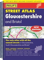
Gloucestershire Philip`s Street Atlas

This fully updated Philip`s street atlas of Gloucestershire and Bristol gives comprehensive and detailed coverage of the region in a convenient spiral-bound format. The route planner shows all the A and B roads, and can be used when driving to get close to the destination before turning to the relevant large-scale street map. The street maps show every named road, street and lane very clearly, with major roads picked out in colour. The maps are at a scale of 3.5 inches to 1 mile, with less populated areas at 1.75 inches to 1 mile. The centres of Bristol, Cheltenham and Gloucester are shown at 7 inches to 1 mile. Other information on the maps includes postcode boundaries, car parks, railway and bus stations, post offices, schools, colleges, hospitals, police and fire stations,
places of worship, leisure centres, footpaths and bridleways, camping and caravan sites, golf courses, and many other places of interest. The comprehensive index lists street names and postcodes, plus schools, hospitals, railway stations, shopping centres and other such features picked out in red, with other places of interest shown in blue.Philip`s Street Atlas Gloucestershire and Bristol is suitable for both business and leisure use.
RIP - This product is no longer available on our network. It was last seen on 25.09.2019

This page now acts as a permanent archive for this product. Add more information using the comments box below to ensure it can still be found by future generations.

Use our search facility to see if it is available from an alternative contributor.
  • Availability: Out Of Stock
  • Supplier: Stanfords
  • SKU: 9781849073660
Availability: In Stock
£12.99

Product Description

This fully updated Philip`s street atlas of Gloucestershire & Bristol gives comprehensive & detailed coverage of the region in a convenient spiral-bound format. The route planner shows all the A & B roads, & can be used when driving to get close to the destination before turning to the relevant large-scale street map. The street maps show every named road, street & lane very clearly, with major roads picked out in colour. The maps are at a scale of 3.5 inches to 1 mile, with less populated areas at 1.75 inches to 1 mile. The centres of Bristol, Cheltenham & Gloucester are shown at 7 inches to 1 mile. Other information on the maps

Includes::
postcode boundaries, car parks, railway & bus stations, post offices, schools, colleges, hospitals, police & fire stations, places of worship, leisure centres, footpaths & bridleways, camping & caravan sites, golf courses, & many other places of interest. The comprehensive index lists street names & postcodes, plus schools, hospitals, railway stations, shopping centres & other such features picked out in red, with other places of interest shown in blue. Philip`s Street Atlas Gloucestershire & Bristol is suitable for both business & leisure use.

Reviews/Comments

Add New

Intelligent Comparison

Oooops!
We couldn't find anything!
Perhaps this product's unique.... Or perhaps we are still looking for comparisons!
Click to bump this page and we'll hurry up.

Price History

Vouchers

No voucher codes found.
Do you know a voucher code for this product or supplier? Add it to Insights for others to use.

Facebook

Jargon Buster

Blue - A primary colour
police - Persons empowered to reduce civil disorder and enforce the law.
Red - One of the three primary colours
Car - A machine used for transport which runs on roads
Colour - The categorised spectrum of light visable to humans
Fire - the release of energy through heat and light.
Large - something that takes up more space than normal.
Road - a manmade lane or a path that is used to speed up travel.
Golf - A sport played on a large outside grass course, the aim to hit a small ball with a club into small holes.
Convenient - Something that suits and fits well to other activities.

Supplier Information

Stanfords
Stanfords was established in 1853 and opened their iconic Covent Garden flagship store in 1901. They have become the top retailer of maps, travel books and accessories in the UK and arguably offer the largest selection of maps and travel books worldwide. Famous names such as Captain Robert Falcon Scott, Ranulph Fiennes and Michael Palin have purchased from Stanfords. They now have a shop in Bristol and both stores together with other venues operate a calendar of events including talks, book signings and exhibitions. As a specialist map retailer, the map selection is comprehensive and includes road maps, street maps and walking maps from worldwide destinations, as well as a selection of world atlases and wall maps. Books include travel guides and travel literature. Stanfords also stock globes, from miniatures made of blue marble to magnificent floor-standing globes. The website features a selection of interesting articles on travel topics.
Page Updated: 2023-11-12 20:15:36

Community Generated Product Tags

Oh No! The productWIKI community hasn't generated any tags for this product yet!
Menu