
 United Kingdom
 France
 Germany
 Netherlands
 Sweden
 USA
USA
 Italy
Italy
 Spain
Spain
More From Contributor


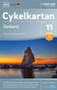

Gotland
Gotland at 1:100, 000 on a double-sided road map from Norstedts with street plans of the island’s four main towns and brief descriptions of 48 places of interest, including fauna and flora and examples of local architecture, all cross-reference to the map.The map show the island’s road network, including small local roads (incorrectly translated in the map legend as “private” roads), indicating waymarked cycle routes. Symbols highlight hotels and boarding houses, holiday camps, campsites and youth hostels, sport and recreational facilities, a wide range of places of interest including historical remains, geological sites of special interest, etc. The map has a 10km UTM grid.Street plans show Visby, Slite, Klintehamn and Hemse. The map includes brief descriptions of 48
main places of interest, ranging from museums and historical remains to best examples of local architecture, nature reserves, etc. Map legend and the descriptions include English.The publishers, Norstedts Kartförlaget, is the now privatized section of Sweden’s national survey organization, Lantmäteriet.
main places of interest, ranging from museums and historical remains to best examples of local architecture, nature reserves, etc. Map legend and the descriptions include English.The publishers, Norstedts Kartförlaget, is the now privatized section of Sweden’s national survey organization, Lantmäteriet.

Product Description
Reviews/Comments
Add New
Vouchers
No voucher codes found.
Do you know a voucher code for this product or supplier? Add it to Insights for others to use.
Do you know a voucher code for this product or supplier? Add it to Insights for others to use.
 Denmark