
 United Kingdom
 France
 Germany
 Netherlands
 Sweden
 USA
USA
 Italy
Italy
 Spain
Spain
More From Contributor


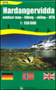


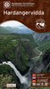
Hardanger Tourist Route
This Hardanger National Tourist Route Map belongs to a series of 18 map and postcards sets describing popular tourist routes all over Norway. The map set includes a map in 1:75, 000 presenting an accurate topography (based on the Norwegian topographic survey) which describes local footpaths, cycle or ski routes, sport and recreational facilities, places of interest, places to stay and eat, viewpoints.The Hardanger National Tourist Route is a 158-kilometre-long stretch of road east of Bergen, in the county of Hordaland in Fjord Norway. Norheimsund, Kinsarvik, Jondal, Granvin and Odda are the five region centres in the area.The route alternates between the dramatic and the gentle: the moorland landscape, the steep mountainsides with thundering waterfalls and the fjord, flat as a
mirror, with peaceful harmony and space for contemplation. The area offers many opportunities for hiking, outdoor adventures and culture experiences. Hardanger is the cradle of national romanticism, and artists of all ages have sought inspiration from its majestic scenery.Hardanger has been a fruit-growing region since the 14th century. The soil along the Hardangerfjord imparts a characteristically fresh and tangy flavour to the fruit, and in the growing season fruit is on sale from small stalls along the road.Several descriptions and illustrations are included in the map to deliver a good visual representation of the trip.The set features:One map: scale 1:55, 000 Text in three languages (Norwegian, English and German)5 Postcards (13.5x25cm)To see the list of other titles in this
series, please click on the series link.
Product Description
Reviews/Comments
Add New
Vouchers
No voucher codes found.
Do you know a voucher code for this product or supplier? Add it to Insights for others to use.
Do you know a voucher code for this product or supplier? Add it to Insights for others to use.
 Denmark